Guidebook, not tourist brochure,
pp. 63-67 · Read in the full issue
was this Hawaii visitor’s friend
Kahoolawe: Though only a few kilometres from Maui, Kahoolawe is one of the least visited islands in the Hawaiian Archipelago, and has been off limits since the military took it over for target practice in World War 11. Before that it was used as ranching land by the McPhee family.
The island has considerable cultural and spiritual significance for the native Hawaiian com munity, and in the late ’7os various Hawaiian activists staged illegal “occupations” of the is land. Eventually an agreement was reached with the navy which provided for monthly access by members of the Kahoolawe Gha na. It was through this Hawaiian nationalist organisation that we were able to visit Kahoolawe in June, 1982.
After camping overnight in Maui, where last-minute details were settled, such as the signing of several “release waivers” for the navy, we proceeded in three boatloads this was one of the largest access groups, including several scientists and reporters the first setting out just before dawn. Baggage was loaded in plastic garbage-bags, and every one brought five gallons of water each, as there is no water on Kahoolawe. The group then joined hands in a circle and of fered a prayer in Hawaiian and English. This Pule, as it is known, is administered by a Kapuna (elder), or Kahuna (priest), and was performed be fore each meal on the island, and again before leaving Kahoolawe.
The boat trip took only one and-a-half hours and passed the tiny horseshoe-shaped islet of Molokini, with its beautiful reef.
Upon arrival, a simple line with plastic bottles attached as floats was stretched to shore (about 100 metres) along which passengers swam. Baggage and the water were then ferried ashore in a Zodiac belonging to the Green peace organisation, and then passed the last few yards by human chain (invariably getting soaked in sea water) to the beach.
A pathway led across the drift wood-strewn brown sands to the settlement itself, which consisted of a communal kitchen, garden, and the framework of a Halau (Hawaiian longhouse) under con struction. Our boat brought bam boo and building materials, and these were floated ashore by swimmers. Some of the Hawaiians had brought symbolic
“gifts to the land,” often plants, breadfruit or coconut wrapped in leaves. (This aspect of things was not advertised, and it was only by chance that we became aware of it.) Around the beach, and in the groves of thorny Kiawe trees, people camped.
Facilities being non-existent, the two adjacent beaches to the main camp served as washing areas, the one on the left for the women and to the right for men. Taboos were placed on sex, alcohol and Pakalolo (marijuana), though en forcement of these was left to the individual.
In the mornings the sun would rise spectacularly over Mt Haleakala across the strait on Maui, and at night the lights of Maui would be clearly visible.
The first night ashore was taken
up largely by speeches on Hawaiian culture, nationalism, and other themes by various members. On the second night a luau (feast) was prepared in a traditional earth oven and served with poi (a thick paste made from pounding the cooked taro root).
People were summoned to the meals and meetings by the sound of a conch shell trumpet.
Much of the daytime was taken up by hikes along the coast and into the hot, dry interior, or by working on the Halau or various camp duties. On the highest point of Kahoolawe (Mt Lua Makika, elevation 450 metres) one could see the islands of Maui, Molokai and Lanai, with Oahu barely visible on the north-western horizon, and the peaks of Mauna Kea and Mauna Loa, on Hawaii, poking up through the clouds in the east.
From this vantage point it was easy to see why the ancient Hawaiians referred to this as the “central” island.
In addition to the Hawaiians, there were geologists, ar chaeologists and botanists in the party, and these all had their respective survey jobs to carry out. All groups leaving the camp had a military escort of bomb disposal men, since the island is covered with shells, rocket bombs, mortars and smaller items of ammunition, some of it live. The continued bombing of Kahoolawe is still a hot political issue, and became more so dur ing the recent RIMAC Exer cises (in which Australian and New Zealand ships participated, but declined to shell Kahoolawe).
During the hikes we saw many archaeological remains, this be-
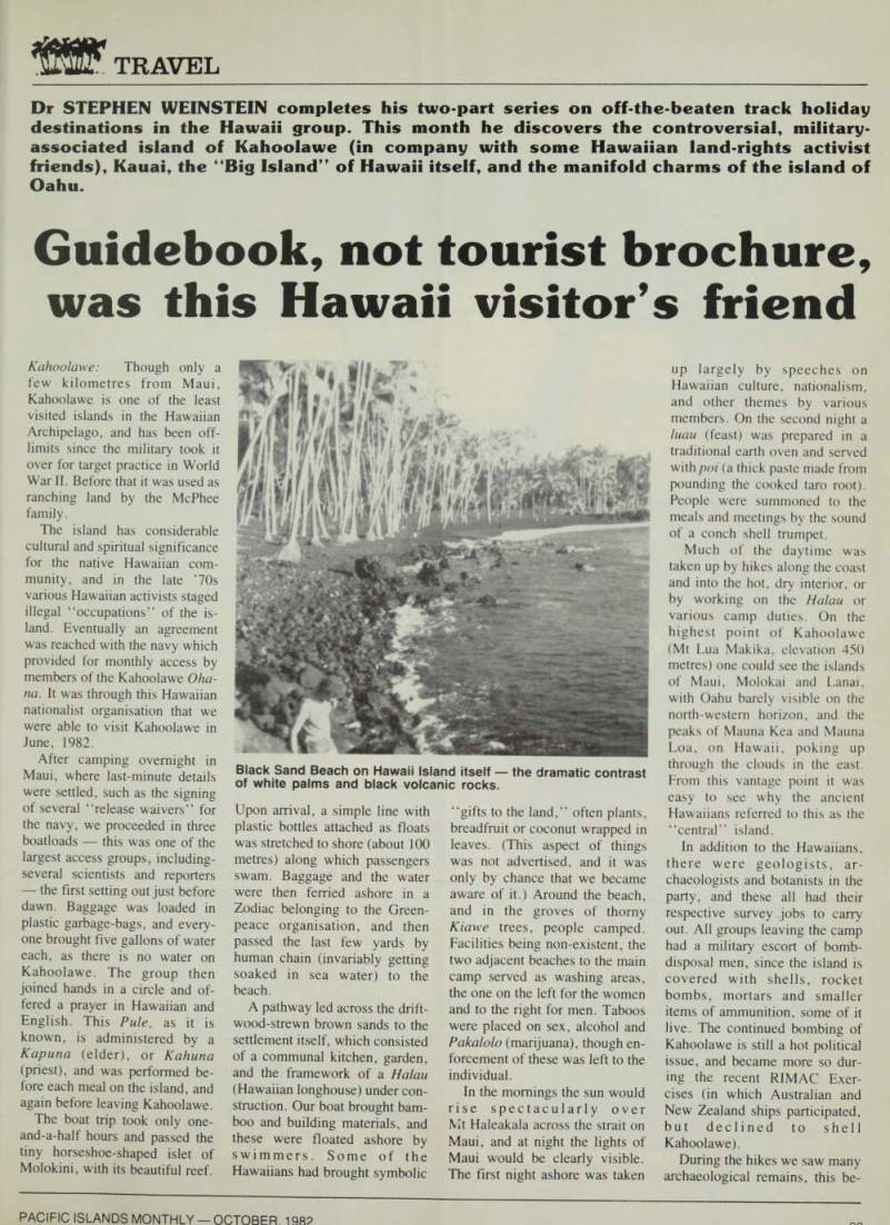
Black Sand Beach on Hawaii Island itself the dramatic contrast of white palms and black volcanic rocks.
ing one of the few places in Hawaii that has not been ex plored with a fine-tooth comb.
House sites and Heiaus (temples) were prominent, with their rec tangular stone bases and walls.
One or two Heiaus have been restored, complete with carved images, by adherents of the an cient Hawaiian religion, which is undergoing a limited revival.
Since Kahoolawe was too dry for agriculture, fishing played a ma jor role in pre-contact times, and there are many Koa (fishing shrines) dedicated to the shark Amakua (spirit), and other deities. In one such Koa a bone fishhook was found, and this was left in a crevice for the benefit of future visitors. It is forbidden to remove any artifacts from Kahoolawe. Cowry shells with bored holes (used as squid lures), and other shells, were also found. The number and distribu tion of these shells are used by archaeologists to calculate popu lation size at a given historical period. Because of its unin habited state, Kahoolawe is sur rounded by beautiful coral reefs well stocked with fish, though many areas are showing signs of destruction. Erosion is wide spread, with very little vegeta tion surviving the combined ef fects of lack of water, bombing, and goats. The silt runoffs reduce the clarity of the water to zero and destroy the corals and marine life at various points on the coast.
On our third day ashore we were joined by “Uncle” Harry Mitchell, a prominent figure in the Ghana. During the recent RIMPAC bombings he “oc
cupied” Kahoolawe by going
over on a surfboard at night. His son was lost with a friend doing the same a few years ago. This grey-haired gentleman is one of the few Hawaiians who retain the skill of navigating by the stars, wind, and swells, as he was taught by his Hawaiian an cestors.
On our last night a huge bon fire was set, and ukulele music and singing carried on through out the night. Two baby goats had been caught from the many that run wild, and one was headed for Guam as a token from Kahoolawe to encourage the
fight for a common cause.
Farewells were emotional as we loaded up the boat again, this time to leave.
Kauai: The single unforgettable part of Kauai is the rugged Na Pali coast, with its beaches and valleys accessible by foot, boat, or helicopter. The best way is probably on foot though, with the distance from the trailhead at the road’s end to Kalalau Beach being 18 kilometres (10 as the crow flies), along some very steep and scenic coastal trail, with numerous switchbacks and “hairy” cliffs. Spur trails lead inland to waterfalls at Hanakapiai and Hanakoa, and there are good views of the sea along the whole trail. We saw
and operate the Robinson’s ranch there. Niihau is the only place where the Hawaiian language has not given way to English. The forerunners of the present owners bought the island from King Kamehameha IV in 1864 for $lO,OOO and it is strictly off limits to all except relatives of the inhabitants, and invited guests of the owners.
Hawaii: The Big Island, as it is called locally, is geologically the youngest in the Hawaiian chain, and the only place where vol canoes are still active. The Vol canoes National Park shows many aspects of vulcanism, with lava flows of various ages, steam vents in the ground, sulphur de
posits, and the highlight
numerous goats, and whales spouting on the horizon. The Kalalau Valley and beach were the site of a few hippie com munities in the ‘6os, and the setting is ideal for “back to nature” living. A waterfall right on the beach serves as a freshwa ter shower, and there are caves nearby for shelter. The valley has ruins of taro terraces from the time when there was a sizable population here, but is now unin habited except for the campers, some of whom never leave.
West from Kauai is the pri vately-owned island of Niihau, where about 200 Hawaiians live
Kilauea caldera itself, the mouth of the crater. The crater floor is black lava, crossed by walking trails with steam vents at regular intervals. The observatory con tains seismographic instruments, and the nearby Volcano House is a hotel located right on the crater rim. The volcano has eruptions occasionally, when fresh lava is pushed out of the crater. Also in the area is the Thurston lava tube, a long tunnel formed by lava cooling around its periphery, while remaining hot and flowing in the centre.
Though this lava tube is lit up inside, a far longer and more
interesting lava tube is found near Hilo, the Kaumana Caves, and for these you need to bring
your own light. They comprise
two lava tubes, the smaller going for about a kilometre and open ing up at the surface at its oppo site end, while the longer goes for many kilometres in the direc tion of Hilo. These tubes are not lit up, and one needs a strong torch to explore them. Needless to say we limited our excursion to the smaller one.
While in Hilo, other sights are the Rainbow Falls, and a few miles outside town the Akaka Falls Park, with paved paths, views of the waterfall, and labelled native plants and trees.
Hilo itself is the second largest city in the State of Hawaii, but does not have much of a tourist industry because of the rainy climate and absence of good beaches. The Kona coast on the other hand has a rapidly expand ing tourist industry, new sub divisions are being carved into the hillsides, and real estate
prices are skyrocketing.
The “City of Refuge” is an interesting complex of recon structed Hawaiian houses, canoes, and a temple with carved wooden images, located on the Kona coast. It is so called be cause in the old days breakers of the taboo could seek refuge from their pursuers (and likely execu
tion) by undergoing certain
purification rituals by the Kahunas (priests) in this temple.
On the northern part of the Kona coast stands the ruins of a heiau built by King Kamehameha I in the last years of the 18th century, before embarking on his con quest of the other islands in the chain that united the Kingdom of Hawaii in 1795. The temple was intended to gain favor war-god Kukailimoku a scheme that was apparently suc cessful. Even today this heiau , as well as others like it, is regarded with a certain respect, and tread
ing on it is strongly discouraged.
The southern tip of Hawaii is called Ka Lae, or the Point, and was the site of the first settlement by the Tahitian voyagers who arrived 1000 years ago in their double-hulled canoes. It is also the southernmost point in the USA. Near Ka Lae is a beach
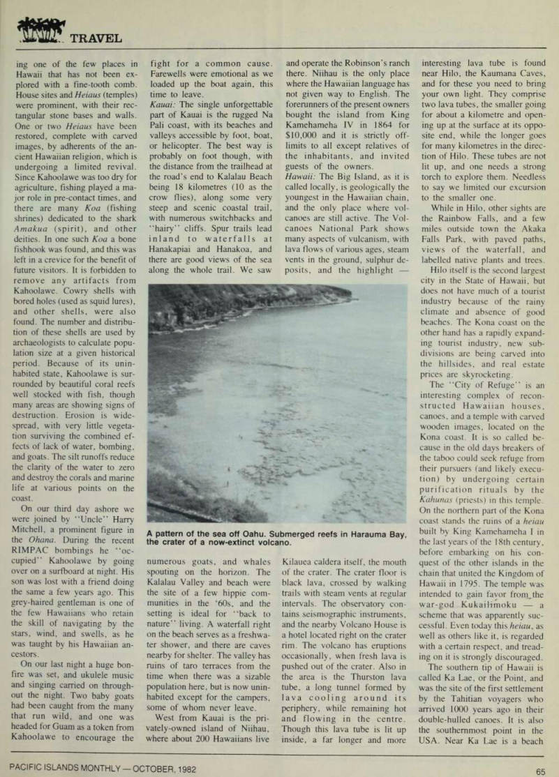
A pattern of the sea off Oahu. Submerged reefs in Harauma Bay, the crater of a now-extinct volcano.
with green sand. The famous Black Sands Beach is also located on the Big Island, the sand being pulverised black lava.
That beach, however, is in the process of being eroded by the sea, and is much narrower today than on photographs of a few years ago. A short drive from Ka Lae brings one to Milolii, said to be the last functioning fishing village in Hawaii.
A last place worth mentioning is the lush Waipio Valley in the northwest, once the site of a flourishing population of 5000. It was the second settlement found ed by the Tahitian voyagers, and it was ruled by the semi legendary King Umi, ancestor of Kamehameha I, who grew up in this valley. Now fewer than 50 people live there, growing taro.
The valley can be reached by four-wheel-drive cars, and an
eight-room, kerosene-lighted
hotel has recently been opened down there. A path following an old Hawaiian foot-trail leads on to the next valley, Waimanu, which is uninhabited, but has an attractive enough setting with beach at one end, waterfall at the other, and a forest full of wild fruits in between.
Oahu: It would be pointless to try to list all the attractions of Oahu in a few sentences, espe cially since this has been done in a myriad of guidebooks already.
However, in summary, what we find most worthwhile, in addi tion to the hiking trails men tioned later, is as follows; For
snorkelling and diving Hana
ma Bay; surfing beaches Sun set, Makaha, Yokohama, and Makapuu (the latter for body surfing); ethnic flavor Chinatown on Maunakea Street; atmosphere of old Hawaii and
the Monarchy period Bishop
Museum, lolani Palace, and the Queen Emma Summer Palace.
The extinct craters of Diamond Head and Punchbowl offer fine panoramas of the city, in addi tion to being famous landmarks in themselves.
There are many beautiful na ture trails that enable one to be entirely alone even on such a crowded place as Oahu. Some worth mentioning are those near Laie, location of the Polynesian Cultural Center and Mormon Temple, which lead into the
Koolau Range and either stop at pools and waterfalls, or eventual ly join the ridge trail that follows the spine of the Koolau Range right down to and past Honolulu.
The Maakua Gulch trail follows
an extremely narrow, winding
gulch with steep, almost perpen dicular walls, until it reaches three little pools and falls, the highest of which can be reached by climbing a rope from the middle one.
The pools are just big enough for a couple of swim strokes.
Sacred Falls is another ter minus of a trail frequented by far more people, but even so there are numerous wild fruits such as mountain apples to be found along this trail in the right sea sons. From the suburbs of Hon olulu begins the Manoa Falls trail, which passes through a bamboo grove. Another interest ing walk, or rather climb, is to follow the 3000 or so steps up the steep windward side of the Koolaus to an old wartime com munications station. The stairs were built by the army after the Pearl Harbor attack, as access to a part of a worldwide Allied radio network. This is one of the lesser known trails, as it is not featured in any hiking books.
Also interesting are the Keai wa heiau and medicinal herb garden where offerings of poi, breadfruit and stones wrapped in ti-leaves can be found. Moanalua
Valley displays petrolyphs on a
solitary huge rock a short walk from the road.
In recent years there have been some rather nasty accidents in which lives were lost when hik ers, intentionally or otherwise, stumbled on guarded or booby trapped pakalolo patches (local Hawaiian word for marijuana) in “off-trail” areas of the moun
tains. Consequently, camping in
or hiking to remote areas is no longer as safe as it used to be.
The little island of Mokolii, or Chinamans Hat, a conical top in Kaneohe Bay, can be reached by wading over at low tide, or paddling over on a surfboard.
The island has a tiny sand beach, a stone monolith said to represent an ancient fishing god, and a few coconut palms. Another island off Oahu that can be reached by a short swim is Mokuauia, a bird refuge opposite Laie.