Uncovering
pp. 45-47 · Read in the full issue
Research
Uncovering the past
Recent exploration of north-east Fiji seeks to resolve debates on the Pacific’s past
Text and photography by Dr Patrick D Nunn
A multidisciplinary scientific team
from the regional university - the University of the South Pacific recently returned from four islands in north-east Fiji. The aim was to uncover details of the ancient history - both human and prehuman - of these islands with a view to resolving some hotly debated issues about the Pacific past.
Although not all the results of the research are yet known, major discoveries of importance were made.
The islands in north-east Fiji, where Lau and Cakaudrove meet, have received little attention from scientists, although
they lie in a critical location for under standing several aspects of the Pacific past. The islands visited by the research team were Mago, Yacata, Kaibu and Vatuvara.
Island origins
Most Pacific islands are formed of vol canic rocks, rocks which solidified from a liquid state. Some islands are composed of limestone, a rock which forms only underwater. Where limestone is found above the ocean surface, it means that land has emerged. The islands visited by the scientific team in north-east Fiji are all high limestone islands - on Vatuvara, the limestone reaches more than 300 metres above the ocean.
The presence of these high limestone islands tells us that they have probably been pushed upwards a considerable amount since the time that the limestone formed. The team was particularly inter ested to know the ages of the limestones on these islands so that the rates at which the islands had been pushed up could be calculated. Such information has the potential to tell us a lot about the nature and rates of processes operating through out the south-west Pacific region.
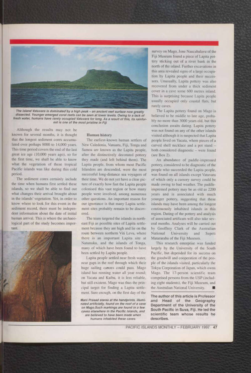
The limestone on the islands visited is in the form of terraces. Each terrace rep resents an ancient coral reef which has been lifted up out of the ocean. The team first mapped these terraces. Then, when their number and distribution was known, they concentrated on finding pieces of coral in these ancient reefs which could be dated.
To map the terraces systematically, the team cut straight lines through the rain forest-cloaked flanks of these islands. On Yacata, a series of seven major terraces each corresponding to an emerged coral reef - were found. Samples have been obtained from most reefs and these will be analysed by Professor Akio Omura at Kanazawa University in Japan. The tech nique of analysis is based on measuring the amounts of various radioactive iso topes in suitable coral samples, by which means the number of years that the partic ular coral has been dead can be discov ered. This uranium-series dating tech nique can date corals which are several hundred thousand years in age. Although the dating will take many months, it is thought the terraces range in age from about 125,000 years to perhaps 2 million years. Once the dates are known, infor mation on the age of these islands and their uplift history will become available.
Vegetation history
In the absence of people, the vegeta tion of a particular area changes as the cli mate changes. Knowledge of past vegeta tion changes can thus be used as a proxy for past climate change, an understanding of which can be used to improve our understanding of both past and future changes in climate.
People undoubtedly altered the vegeta-
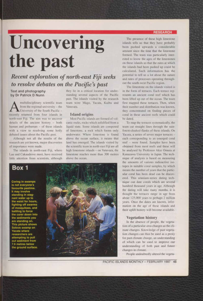
Box 1
Coring in swamps is not everyone’s favourite pastime.
It may involve standing in stag nant water up to the waist for hours, fighting off swarms of mosquitoes, and battling to force the corer down into the sediments you are standing on.
This picture shows Solove swamp on Yacata where researchers are attempting to pull out sediment from 7,6 metres below the ground surface.
tion upon first arriving on the islands. The degree of alteration is something which is debated. Some scientists believe that the alteration was comprehensive, that the earliest Pacific islanders burned the entire vegetation of the islands they settled, replacing it with something quite differ ent. Other scientists believe that the impact of the first human settlers was much less.
One way of resolving this debate is to compare the vegetation history and the
history of human settlement. This is what the scientific team attempted on the islands they visited. To discover the vege tation history of these islands, the team dug holes in freshwater swamps. These swamps, which originated as hollows in the limestone, have had sediment (usually mud and sand) accumulating in them for thousands of years. This sediment has been washed off the uplands along with spores of the plants growing there. Each layer of sediment in the swamp thus rep resents a slice of time in which the nature of the upland vegetation is preserved.
Further, whenever the upland vegetation was burned, perhaps by humans, charcoal would have accumulated in the swamps.
Thus, by careful examination of the dif
ferent layers of sediment found in the swamps, the history of vegetation change and burning can be worked out.
The thicknesses of sediment in the swamps on Mago, Yacata and Kaibu were surprisingly great (see Box 1). More than seven metres of sediment was recorded in several swamps. The layering in this sed iment was recorded, along with other fea tures such as concentrations of shells or charcoal. The sediment was sampled at regular intervals; samples will be anal ysed by Dr Geoffrey Hope of the Australian National University for their pollen content, and dated at appropriate places using the radiocarbom technique.
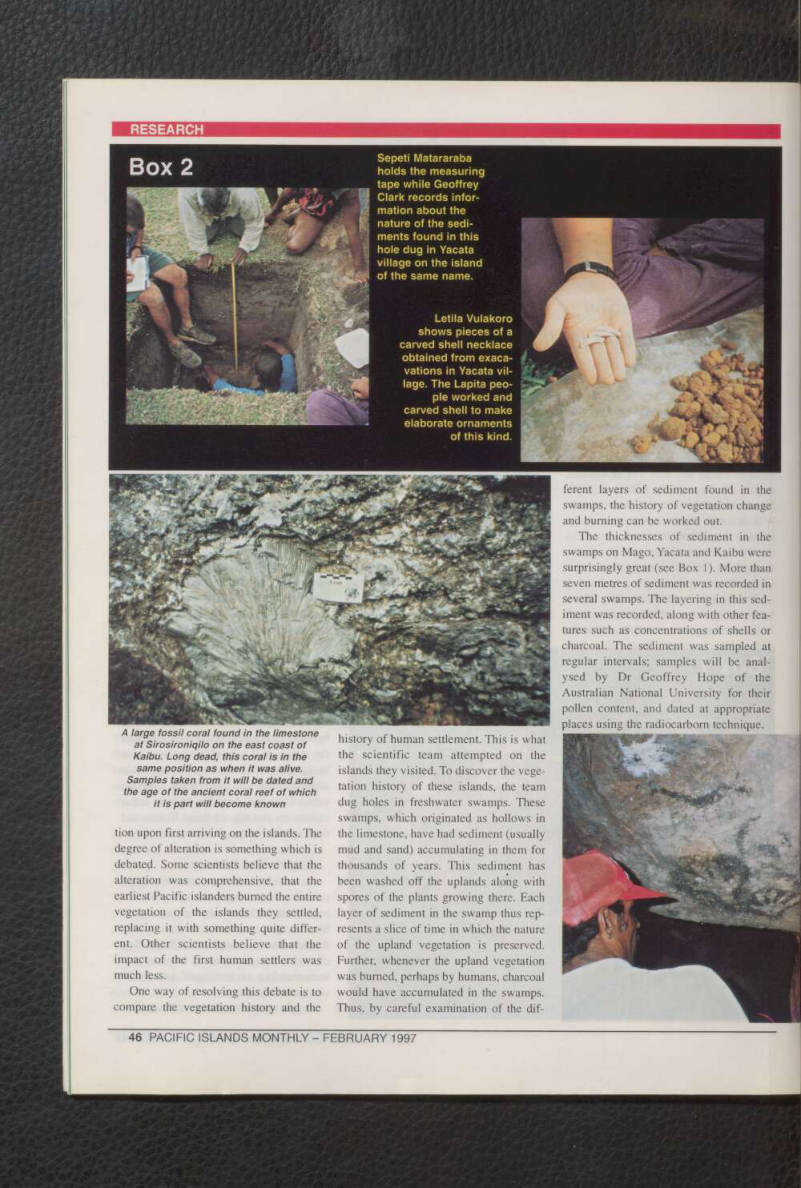
Sepeti Matararaba holds the measuring tape while Geoffrey Clark records infor mation about the nature of the sedi ments found in this hole dug in Yacata village on the island of the same name.
Letila Vulakoro shows pieces of a carved shell necklace obtained from exaca vations in Yacata vil lage. The Lapita peo ple worked and carved shell to make elaborate ornaments of this kind.
Box 2
A large fossil coral found in the limestone at Sirosironiqilo on the east coast of Kaibu. Long dead, this coral is in the same position as when it was alive.
Samples taken from it will be dated and the age of the ancient coral reef of which it is part will become known
Although the results may not be known for several months, it is thought that the longest sediment cores accumu lated over perhaps 8000 to 14,000 years.
This time period covers the end of the last great ice age (10,000 years ago), so for the first time, we shall be able to know what the vegetation of these tropical Pacific islands was like during this cold
period.
The sediment cores certainly include the time when humans first settled these islands, so we shall be able to find out what changes their arrival brought about in the islands’ vegetation. Yet, in order to know where to look for this event in the sediment record, there must be indepen dent information about the date of initial human arrival. This is where the archaeo logical part of the study becomes impor tant.
Human history The earliest-known human settlers of New Caledonia, Vanuatu, Fiji, Tonga and Samoa are known as the Lapita people, after the distinctively decorated pottery they made (and left behind them). The Lapita people, from whom most Pacific Islanders are descended, were the most successful long-distance sea voyagers of their time. We do not yet have a clear pic ture of exactly how fast the Lapita people colonised this vast region or how many people were involved, among numerous other questions. An important reason for our ignorance is that many Lapita settle ment sites probably remain to be discov ered.
The team targeted the islands in north east Fiji as possible sites of Lapita settle ment because they are high and lie on the route between northern Viti Levu, where there is an important Lapita site at Natunuku, and the islands of Tonga, many of which have been found to have
been settled by Lapita people.
Lapita people settled near fresh water, near gaps in the reef through which their huge sailing canoes could pass. Mago island has running water all year round; on Yacata and Kaibu, it is less reliable, but still existent. Mago was thus the prin cipal target for finding a Lapita settle ment. Sure enough, on the first day of the
survey on Mago, Jone Naucabalavu of the Fiji Museum found a piece of Lapita pot tery sticking out of a river bank in the north of the island. Further excavations in this area revealed signs of a large occupa tion by Lapita people and their succes sors. Unusually, Lapita pottery was also recovered from under a thick sediment cover in a cave some 600 metres inland.
This is surprising because Lapita people
usually occupied only coastal flats, but
rarely caves.
The Lapita pottery found on Mago is believed to be middle to late age, proba bly no more than 3000 years old, but this conclusion awaits dating. Lapita pottery was not found on any of the other islands visited although it is suspected that Lapita people lived on Yacata, where pieces of a carved shell necklace and a pot stand both considered diagnostic - were found (see Box 2).
An abundance of paddle-impressed pottery, considered to be diagnostic of the people who succeeded the Lapita people, was found on all islands except Vatuvara of which only a cursory survey could be made owing to bad weather. The paddle impressed pottery may be as old as 2200 years and is associated with much younger pottery, suggesting that these islands may have been among the longest continuously inhabited islands in this region. Dating of the pottery and analysis of associated artificats will also take sev eral months. Analyses will be carried out by Geoffrey Clark of the Australian
National University and Sepeti
Matararaba of the Fiji Museum.
This research enterprise was funded largely by the University of the South Pacific, but depended for its success on the goodwill and cooperation of the peo ple of the islands visited, particularly the Tokyu Corporation of Japan, which owns Mago. The 17-person scientific team comprised persons from the USP (includ ing eight students), the Fiji Museum, and the Australian National University. ■
The author of this article is Professor and Head of the Geography Department of the University of the South Pacific in Suva, Fiji. He led the scientific team whose results he describes.
The island Vatuvara is dominated by a high peak —an ancient reel surface now greatly dissected. Younger emerged coral reefs can be seen at lower levels. Owing to a lack of fresh water, humans have rarely occupied Vatuvara for long. As a result of this, its rainfor est is one of the most pristine in Fiji
Marti Prasad stares at the handprints, illumi nated artificially, found on the roof of a cave on Mago.Such markings are found in a few caves elsewhere in the Pacific Islands, and are believed to have been made when humans inhabited these caves