and espionage
pp. 42-43 · Read in the full issue
Navigation, art, and espionage
Printed here is the first part of a three-part reproduction of a lecture given earlier this year in Sydney by Professor Bernard Smith entitled “The Functions of Art on Cook’s Voyages”. The lecture was second in the series known as The Dulcie Stretton Lecture, sponsored by The Library Society of the State Library of New South Wales.
Art historian Professor Smith is the co-author, with Dr Rudiger Joppien, of The Art of Captain Cook’s Voyages, a three-volume study, the first two volumes of which were published this year by Oxford University Press. The two volumes will be reviewed in an early issue of PIM.
Both Joseph Banks and James Cook on several occasions asserted that drawings were often better than words for describing unfamiliar scenes and unfamiliar things. As a result of Banks’s initiative the voyage of the Endeavour to the South Pacific was the first major voyage of exploration to sail with a full complement of artists and to bring back a comprehensive graphic record of the voyage. On its return it carried with it over 100 manuscript charts and more than 200 coastal views of value to later navitagors, over 1000 drawings of plants and animals of value to natural scientists, and almost 200 drawings of the native peoples of the South Pacific, their artifacts and the environments in which they lived, of great value to the still infant science of anthropology. Yet most of this material has remained unpublished until recent times, and what has been published has appeared mostly in specialist publications.
For almost two centuries historians have relied upon the written documents for Cook’s explorations, using the engravings from time to time, not as documents to be interpreted but as mere embellishments to their written accounts. They have been, and to a large extent still are, visually naive, ignoring the advice of Banks and Cook that drawings are often better than words in the description of unfamiliar things. Indeed visual records can do more than describe the unfamiliar, they can often throw new light on events and the motives and interests of the voyagers.
When Cook sailed in 1768 skills in drawing were still not fully appreciated in the British navy. Two years later Cook himself noted that he did not know many seamen “who were capable of drawing a chart or sketch of a Sea Coast.” But a major change took place between 1768 and Cook’s death in 1779; in those 11 years the navy came to realise fully the value of drawing skills for the purpose
of compiling information.
The art completed on Cook’s voyages can be said to fall into four main categories. First, charts and views drawn to assist navigation and naval intelligence; second, drawings made to document and classify previously unknown plants and animals; third, drawings of ethnographical value, such as portraits and figures of native peoples, their habitations and artifacts, and the environments within which they lived; and fourth, drawings made as visual records of significant events of the voyage. I shall discuss each category in turn and the function that kind of art served. For the first question we should ask of any drawing is, what purpose was it intended to serve?
On the Endeavour there were three men who could lay down a chart with competence. Cook himself, who in 1766 had published his admirable charts of Newfoundland after “the most thorough hydrographical survey yet made by an Englishman overseas,”
Molyneux, the Master, on whom the responsibility of chart-making directly fell, and Pickersgill, the Master’s mate. Together these three were able to compile 102 charts, all of which will be published for the first time, in the first volume of the three-volume edition of the Charts and Views of Cook’s Voyages, which the Hakluyt Society propose to publish as complementary volumes to The Art of Cook’s Voyages. The folio of Charts and Plans which the Society published to supplement their edition of Cook’s Voyages edited by the late Professor Beaglehole published only 24 charts from the first voyage.
Cook placed great value upon the production of accurate charts and was aware of the value of drawing coastal views. He had drawn views himself for some of his North American charts and
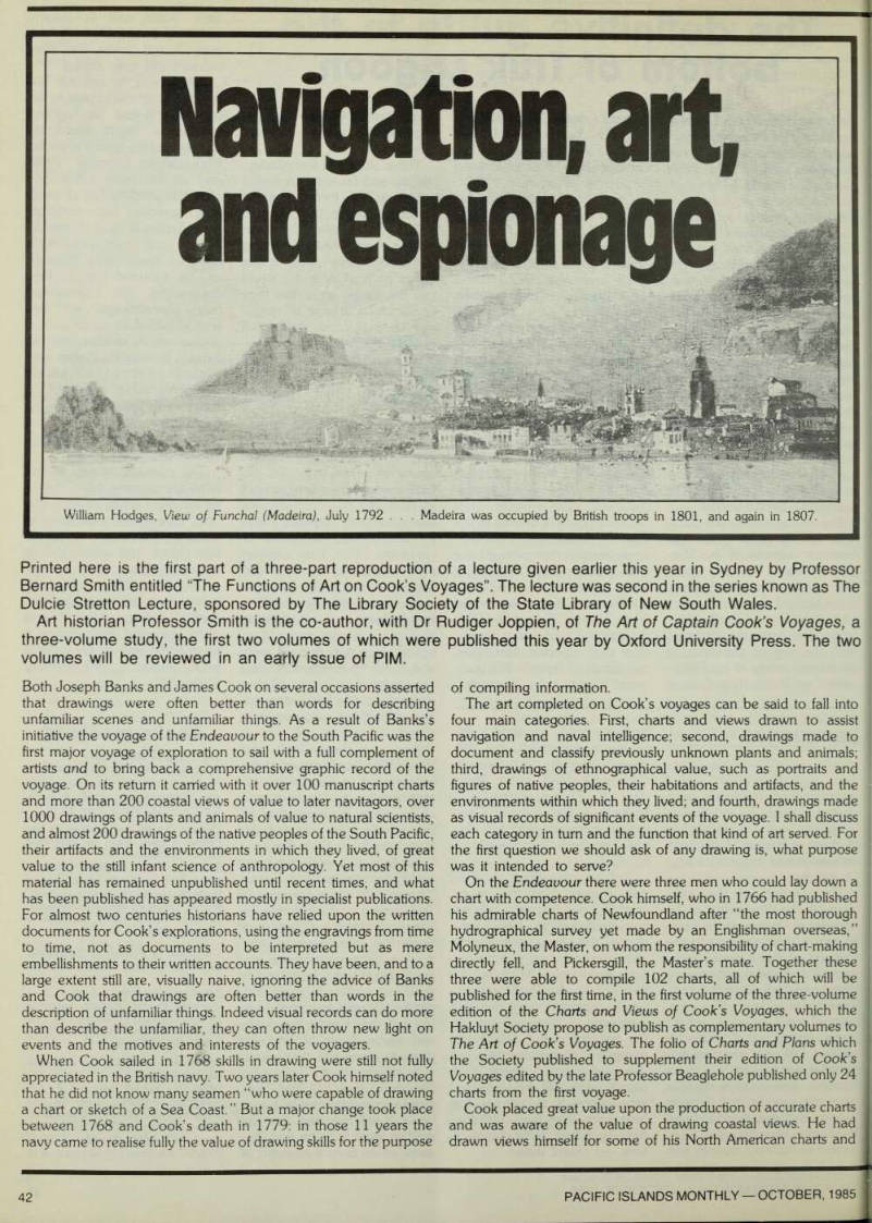
William Hodges, View of Funchal (Madeira), July 1792 . . . Madeira was occupied by British troops in 1801, and again in 1807.
some of these were published together with his Directions for Navigating in Newfoundland (1766), and he would certainly have known and probably made use of the excellent coastal views in Greenville Collins’s Great-Britain’s Coasting Pilot, first published in 1693.
Nevertheless in 1768 skills in charting and drawing views were still not common among seamen and on the Endeavour it was the young artists employed by Banks, Sydney Parkinson, Alexander Buchan and Hermann Sporing who drew most of the coastal views made on the voyage. Parkinson, though employed as the natural-history draughtsman, drew the peak of Teneriffe, and after they were about a month at sea and nearing the island of Bona Vista in the Cape Verde group, Banks noted in his Journal that “Mr Buchan,” the young artist he had taken to depict the Polynesians, “was employed in taking views of the land. ” Cook also mentions in the Journal on the same day that two views were taken of the island. Presumably they were Buchan’s views, which are now lost.
Thus began a continuous program to draw views whenever land was in sight and virtually all of them were drawn by Banks’s young artists. As J.R.H. Spencer has recently shown, Molyneux even left spaces in his log to be filled in with coastal views by Parkinson. All this is no more than we might expect. Cook, with Banks’s approval, was making the best use of talent available. But we may note that what was soon to become a normal naval practice was undertaken on the Endeavour by a rather incompetent figure draughtsman and a skilled botanical illustrator.
In the production of coastal views as in other ways Cook made the best use he could of the talent available. On his second voyage, William Hodges, the landscape painter, was directly under his control, and he asked Hodges to set up a little drawing school in the great cabin to teach the young midshipmen, John Elliott, Henry Roberts, Isaac Smith, the art of drawing coastal views. Hodges taught them to draw in tone and color rather than in line, which was the practice on the first voyage. That method indicated internal distances more skilfully.
Such views were of value mainly for navigation; but sketches of ports and harbors could be of great value for naval intelligence.
Historians have often commented favorably on the tendency of the British to publish their voyages of exploration whereas the Portuguese, Spanish and Dutch tended to keep them secret. There is some truth in this, but the element of secrecy in British voyages also should not be ignored. It was stressed in Cook’s official instructions. For example, the instructions for the second voyage required that before he left the ship “to Demand from the Officers and Petty Officers ... the Log Books and Journals they may have kept, and to seal them up for our inspection, and enjoining Them and the whole Crew, not to divulge where they have been, until they shall have permission so to do.”
Most historians of Cook’s voyages have tended, either explicitly or implicity, to be critical of the unduly suspicious nature of the reception which Cook received at Rio from the Portuguese Vice Roy, who severely restricted the movements of the Endeavour s company. They have tended to take Cook’s plea that he was engaged on a purely scientific expedition at face value. But the Vice Roy had grounds for suspicion. We should not forget that Cook was also the man who charted the St Lawrence preparatory to Wolfe’s successful assault upon Quebec; and during the Endeavours stay at Rio, Alexander Buchan made five detailed topographic drawings of the harbor of Rio and its fortifications, by looking through the windows, within the secrecy of the En deavour’s great cabin. Cook and Banks wrote full accounts of the fortifications of Rio in their Journals and both provided suggestions as to how the forts might best be attacked.
On his second voyage the Governor of Madeira extended a welcome to Cook provided “no Plans or drawings be made of any of the Fortifications, a very reasonable restriction and very readily promised on my part,” Cook wrote in his Journal. Yet he seems to have taken no precautions to honor his promise even if he did not deliberately break it. For William Hodges, from the great cabin,
made a drawing of Funchal and its fortifications (it only came to light recently), and also a fine painting.
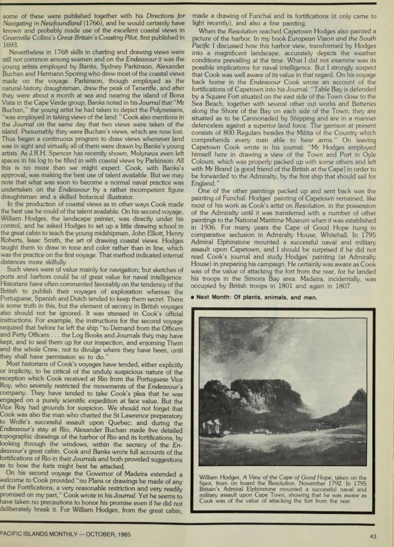
When the Resolution reached Capetown Hodges also painted a picture of the harbor. In my book European Vision and the South Pacific I discussed how this harbor view, transformed by Hodges into a magnificent landscape, accurately depicts the weather conditions prevailing at the time. What I did not examine was its possible implications for naval intelligence. But I strongly suspect that Cook was well aware of its value in that regard. On his voyage back home in the Endeavour Cook wrote an account of the fortifications of Capetown into his Journal. “Table Bay is defended by a Square Fort situated on the east side of the Town close to the Sea Beach, together with several other out works and Batteries along the Shore of the Bay on each side of the Town; they are situated as to be Cannonaded by Shipping and are in a manner defenceless against a superior land force. The garrison at present consists of 800 Regulars besides the Militia of the Country which comprehends every man able to bear arms. ” On leaving Capetown Cook wrote in his journal: “Mr Hodges employed himself here in drawing a view of the Town and Port in Oyle Colours, which was properly packed up with some others and left with Mr Brand [a good friend of the British at the Cape] in order to be forwarded to the Admiralty, by the first ship that should sail for England. ”
One of the other paintings packed up and sent back was the painting of Funchal. Hodges’ painting of Capetown remained, like most of his work as Cook’s artist on Resolution, in the possession of the Admiralty until it was transferred with a number of other paintings to the National Maritime Museum when it was established in 1936. For many years the Cape of Good Hope hung in comparative seclusion in Admiralty House, Whitehall. In 1795 Admiral Elphinstone mounted a successful naval and military assault upon Capetown, and I should be surprised if he did not read Cook’s journal and study Hodges’ painting (at Admiralty House) in preparing his campaign. He certainly was aware as Cook was of the value of attacking the fort from the rear, for he landed his troops in the Simons Bay area. Madeira, incidentally, was occupied by British troops in 1801 and again in 1807. • Next Month: Of plants, animals, and men.
William Hodges, A View of the Cape of Good Hope, taken on the Spot, from on board the Resolution. November 1792. In 1795 Britain’s Admiral Elphinstone mounted a successful naval and military assault upon Cape Town, showing that he was aware as Cook was of the value of attacking the fort from the rear.