jack-in-the-box
pp. 30-33 · Read in the full issue

Lateiki: Tonga’s new jack-in-the-box island
The story of the Pacific's newest island Lateiki, in Tonga's Vavau group is told in detail by E. A. Crane, writing from Nukualofa.
For good measure the writer seeks a fundamental explanation for the appearance of this (and other) islands as he outlines briefly the theory of ‘plate tectonics', which is finding increasing acceptance among earth scientists throughout the world. E. A. Crane, MA, is assistant principal of Nukualofa's Tupou High School.
Another ‘jack-in-the-box’
island has been thrown up by a volcano on the western sub-
marine ridge of Tonga. Lying
between the volcanic cones of Kao and Late, it has been
named by King Taufa’ahau
Tupou IV of Tonga, Lateiki, which means ‘it lies beside Late’. Although not so wellknown as Falcon Island, renamed Fonua Fo’ou (new land) by the Tongans, which has been raised by an undersea volcano four times in the past 200 years and eroded away by the sea each time, Lateiki is already staking its own claim to
fame by rising and sinking
twice in the past 100 years. It has now been reborn for a third time.
In 1875 the British frigate, HMS Metis, while charting this area, found a small volcanic island protruding out of a shallow platform which the captain named Metis Shoal. Volcanic activity continued for the next
15 years, gradually building the island higher. When HMS Sappho saw it in 1878 it was 200 m long and 37m high. In 1890 its height was given as 480 m. From then on volcanic activity ceased, and by 1898 waves had worn away the loose ash and rock until it was again a shoal with 4m of water over it.
Twelve years ago, in December 1967, Metis Shoal
erupted again, throwing up
dense clouds of steam, smoke, and ash. A small island of loose rocks and ash was formed, and the King of Tonga visited the area by aircraft to see this small extension of his kingdom. But by the end of 1968 the island
had completely disappeared
under the relentless sea.
Then three months ago
Metis Shoal began erupting
again. On May 1 sailors on the New Zealand cargo ship Marama reported clouds of steam rising into the air on the
distant horizon. Sailors on the Tongan vessel Niukavai, on its way from Samoa to New Zealand, passed closer to the shoal and reported that the sea was boiling, and saw clouds of steam and ash rising high into the air. On May 10 an orbiting
satellite reported steam rising
from a Tongan volcano.
Reports then began to come in from distant ships and air craft of a strange phenomenon a ‘sea of pumice’ 190 km long and 50km wide drifting away towards Fiji (PIM, August).
Samples of the pumice were collected by two Fiji naval vessels near Vanua Balavu. In the first week of June the New Zealand navy frigate, HMNZ Canterbury sailed into the pumice field on its way to
Tonga. The engine intakes
sucked in the pumice and turned it to mud, but the ship was not damaged.
This pumice had originated
from the eruption on Metis Shoal. The eruption had begun when gas building up in the
underlying magma suddenly
burst forth in frothing bubbles of red-hot lava. As these bubbles came into contact with the water and air above, they
solidified quickly into light,
buoyant rocks containing
countless air pockets left by the escaping gas. One observer on
a Tonga Air plane reported this
pumice floating away from
Metis Shoal still steaming, and with one piece ‘as big as a motor car’.
As the eruption built up, ash, pumice and lava blocks were thrown out in continuous ex plosions up to 200 metres, and a pilot of Tonga Air saw a column of smoke and steam rising to 3000 m, high above the cloud layer. Captain R. Jones, also of Tonga Air, said he saw the gradual birth of the island over four days, from June 19 to 23. He said: it was tremen dously spectacular each time I flew back over it a fantastic experience I will never forget’
(PIM Sept).
Captain Jones said the erup tion hurled small rocks as high as 150 m into the air when he flew over it. There was no sign of land anywhere around, although round the centre of the smoke he saw the green outline of a subterranean peak in the midst of the blue sea. But instead of being deposited all around the rim of the crater, the ash, sand, and rock were deposited only on its northwest arc, probably due to the strong southeast winds blowing it in that direction.
A new island rising out of the sea was an event to celebrate with royal ceremony. On
Saturday, July 7 His Majesty
King Tupou IV sailed to the island on the MV Sami, and on
Sunday, July 8, His Royal
Highness Prince ‘Aho’eitu led a landing party to the island to raise the Tongan Flag and claim it for Tonga.
When the flag-raising party returned to the ship to report to the king that the task had been carried out, a service of thanksgiving was held on deck. ‘The president of the Free Wesleyan Church, Rev Huluaholo Mo’ungaloa, men tioned that the new island was like a blessing from God to His Majesty on his 61st birthday (July 4). After the service the King named the island Lateiki saying: ‘I believe that the island is given as a blessing to
all Tonga’.
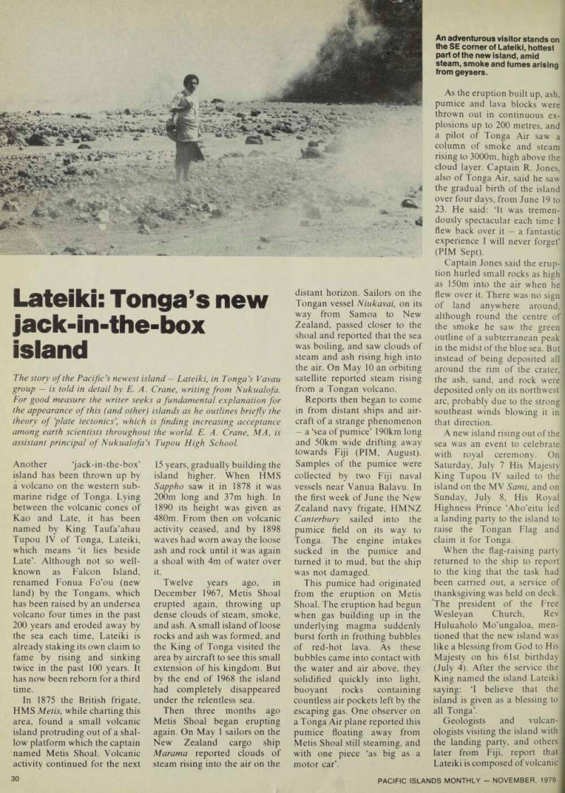
Geologists and vulcan ologists visiting the island with the landing party, and others later from Fiji, report that Lateiki is composed of volcanic
An adventurous visitor stands on the SE corner of Lateiki, hottest part of the new island, amid steam, smoke and fumes arising from geysers.
>h. pumice, and dark grey or lack basalt (lava rocks). It has n area of 3ha, is 320 m long nd 120 m wide. Its steep mthem end curves in an arc f cliff's rising 16m in the south west to 10m in the southeast, rom the tops of these cliff's the md slopes down almost to sea ivel on the northern end. lack volcanic sand circles the hole island. Scattered all over ic island are large boulders of
asalt, some being 3m high and
m long. While the outer sur ice of these boulders is hard, lack rock, the inside of the >cks is granular and softer. On ic island too are many
imeroles (holes) emitting sul
hur dioxide with its strong,
ilty odour.
In front of the cliff's is the live mtre of the volcano. When lis is exposed at low tide, ouds of steam and fumes of ilphur dioxide come out of ic central vent. These clouds
rise to over 20m and then spread over the whole Island.
At high tide, when the live crater is submerged, the sea boils and volcanic sands rise into the air in black foun tains.
How did Lateiki arise? There is no doubt that it is part of a chain of volcanoes that have raised peaks and islands on the crest of a long submarine ridge stretching 3000 km from Samoa to the southeast of New Zealand. In the Tongan group the existing volcanic islands of Ata, Hunga Tonga and Hunga Haapai, Tofua, Kao, Late, Fonualei, Tafahi, and Niuafoou rise out of the ridge from south to north. Kao, Late, Fonualei and Tafahi are per fect cones, but violent erup tions 10-20 000 years ago caused the sides of Tofua and Niuafoou to collapse into holes left by the ejected magma forming large calders 7-Bkm in width.
But in other places along the ridge less violent eruptions are
occurring today which, after
throwing out relatively small
amounts of lava, pumice, rock and ash, quickly subside as they are washed away by the sea. They occur at Fonuafoou, just north of the Hungas, Metis Shoal, close to Late, and Cura cao Reef 24km north of Tafahi.
Three undersea eruptions have occurred at Curacao Reef since 1973, but although dense clouds of steam were thrown into the air, no islands were formed.
Most earth scientists today are accepting the new theory of plate tectonics as an expla nation for these volcanoes.
This theory, reinforced by find
ings from ships drilling the
ocean floor, and submersibles that explore the rugged ocean terrain to depths up to 3000 m, is that the earth’s thin outer shell is split up into gigantic, irregular-shaped blocks called plates. These move slowly over the globe, only a few centi metres each year, carrying con tinents, islands, and oceans on their backs. Where two plates collide with each other or con tinents, they slowly pile the edges up into massive moun tain ranges, but where they col lide under oceans they form ridges and deep trenches, and Continued next page
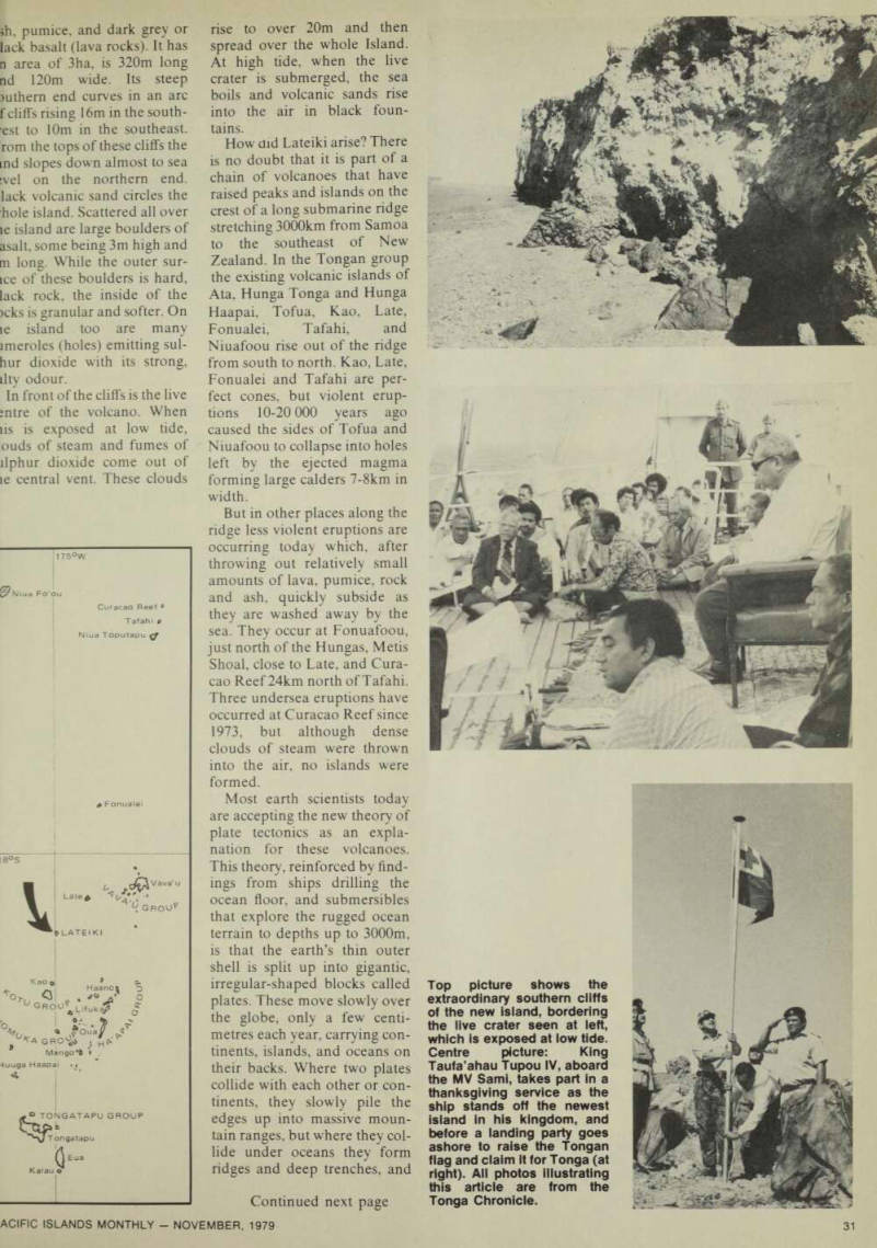
Top picture shows the extraordinary southern cliffs of the new island, bordering the live crater seen at left, which is exposed at low tide.
Centre picture: King Taufa’ahau Tupou IV, aboard the MV Sami, takes part in a thanksgiving service as the ship stands off the newest island in his kingdom, and before a landing party goes ashore to raise the Tongan flag and claim it for Tonga (at right). All photos illustrating this article are from the
Tonga Chronicle.
long the ridges there is usually
mch volcanic activity.
Plate tectonics provides a
rmvincing explanation of the
urination of Tonga’s volcanic
lands, its deep eastern seas, nd the occurrence of its severe arthquakes. It is believed that ic plate carrying Asia and ustralia is riding over the dge of the giant Pacific plate nd the meeting-place of the
vo plates is the high sub
larine ridge extending from
amoa to New Zealand. The lovement of the Asia
.ustralia plate eastwards is
ircing the Pacific plate mov ig westwards to bend down ards and push it away at a low ngle deep into the earth’s lantle.
These contrary movements >rce up a ridge on the edge of
ic Asia-Australian plate, and
ush down a deep V-shaped
ough where the Pacific plate
egins to dip. This trough,
nown as the Tonga Trench, is early 3000 km long, 100 km ide, and extends to a depth of lore than 10 000 m at one oint, the second lowest depth i the Pacific Ocean.
As the Pacific plate moves ownwards some of its rocks iclt at a depth of 100-160 km. lost of this molten material dols and solidifies before it caches the surface. Some of it, owever, pours out as fiery
iva erupting violently from
olcanoes, while some of it is ushed up like putty through racks in the surface. As a re alt the submarine ridge from
Samoa through Tonga to New Zealand has become a ‘fiery arc’ of volcanoes, most of them dormant now but liable to burst out afresh at any time, as the new volcanic island of Lateiki shows.
Earthquakes occur when rocks under great pressure move suddenly to relieve the strain. Where rocks are shallow
they are comparatively hot, pli
able and ‘soft’, so when they
break only gentle earthquakes
occur. The cold, rigid rocks of the Pacific plate can withstand much greater pressures, but
when they finally give way
along the opposite moving
edge of the Asia-Australia plate much more violent earth quakes occur. Such severe earthquakes have done great damage to life, property and landscape in New Zealand in 1931 and in Tonga in 1977.
A knowledge of plate tec tonics is not really helpful in enabling us to predict future
eruptions or earthquakes, as
events occur across a slow
moving timespan of thousands
of years. But it is helpful in explaining the reasons for pre sent volcanic activity and earthquakes. At least in the short term we can predict with confidence that Lateiki, the world’s newest island, is doomed to extinction before many years have passed.
Lateiki, seen from the south, showing the active crater facing the line of cliffs. The sketch shows the anatomy of the new island.