Secret Discovery of Australia,
pp. 55-59 · Read in the full issue

or the mystery of the maps
This attractive volume, The Secret Discovery of Australia, by K. G. Mclntyre, beautifully written and illustrated, will at once remind the reader of Robert Langdon’s The Lost Caravel and deals with the same period of little-known history in our part of the world.
Em tempted to call it our “Dreamtime”, for the few documented facts and the uncertain nature of the clues we have, make historical re search similar to the interpret ation of dreams, and open to the same degree of contro versy.
As with the flying-saucer books, the general reader be comes a “believer” or an unbe liever, and most writers of book reviews for the popular press
generally give a new theory the
benefit of the doubt, and de clare that “Our History books must be rewritten!” The theory behind the Secret Discovery is not new, but started just after the death of Cook, and has been put forth in varying form at intervals ever since, the last
great “believer” being George
Collingridge of Sydney, in his book printed in 1896, The Dis covery of Australia.
The theory is that the entire eastern, northern and western coasts of Australia were dis covered and charted by two Portuguese expeditions in 1522 and 1525. The first was under Cristavao de Mendonca and Pedro Eanes, the second under Gomes de Sequeira and Diogo de Roca. The only documen tary evidence about the first voyage was that it began from Malacca in early 1521, heading south-east, and that Mendonca survived the voyage, as a man of the same name was Gover nor of Ormuz in later years.
The second expedition left Ternate in July, 1525, heading for the Celebes, from whence it was driven by storms to the East, for 900 leagues. As the island of Celebes stretches from 2° North to s Vi° South,
this may have taken them either north of New Guinea, or to the south of it. They are be lieved to have reached the islands of Timorlaut and Aru, between Timor and New Guinea.
A few years later a Por tuguese chart by an unknown map-maker shows the East Indies as far as the islands off the western end of New Guinea, but both Java and Subawa are shown without southern coasts. This forms an
important clue in Mclntyre’s
theory. His next step is to pos tulate a Portuguese map of Australia, showing all the northern half of the island continent, as discovered by Mendonca and Sequeira. This was kept “top-secret” in the India Office in Lisbon. There are no known Portuguese or
Spanish charts showing Aus
tralia at this date, nor even New Guinea.
The next step in the secret history is that a copy of this chart was stolen, smuggled out or “leaked” to a spy who was working for the French map makers of Dieppe, probably in 1540.
The stolen copy, which may have been in separate pieces, probably contained a scale of
latitude, but not one of longi tude, as that was a very vague estimate in those days. To join this newly-found continent on to the East Indies for drawing their maps of the world. The
Deippe cartographers put it
about 1 500 miles (2 400 km) to the west, and about 300 miles (480 km) to the north, so that Arnhemland covered Java, and Cape York Peninsula became Sumbawa Island.
Between them is a gap, in which can be seen the islands of Bali and Lombok in their correct places. The gap varies a lot in the successive charts made in Dieppe so we can guess that the Gulf of Carpen taria had not been shown in any detail on the stolen chart,
being unexplored. The details
of Arnhemland and Cape York disappear in the islands of Java and Sumbawa, so that the only Australian coasts left are those to the east and west, below about 17° South. The coast of Western Australia is charted down to about 35° south, and the east coast down to 60° south. Most of the Dieppe charts then join these coasts on to the great unknown South land. Dozens of the capes, bays, points and rivers carry names which are Portuguese,
Books
or translated into French, in some cases becoming unin telligable in the process, like the name Gouffre which
appears against many gulf-like
inlets, including Port Phillip
Bay in Victoria. The new con tinent is named Jave-la- Grande, possibly from the Latin version Java Major, leav ing the real island of Java with its old name.
The Dieppe maps were drawn over the period 1540 to 1566 by at least five known men, and 10 of the maps are still in existence. They were all
large and beautifully painted
and embellished, not intended for any navigational purposes, but as “wall enrichments” in
royal and wealthy homes. They
probably remained out of sight from common eyes, and the continent of Jave-la-Grande did not appear on any charts
made in places beyond Dieppe
itself. All other cartographers had to fill in the blank space below the Indies with the lands which Marco Polo heard about in Indo-China. These fabled lands of gold and elephants formed the northern lumps and bumps of Terra Australis
Incognita, sometimes joining
on to New Guinea after the northern part of that island was charted in 1545.
The first of the Dieppe charts to arouse interest was one presented to the British Museum by Sir Joseph Banks in 1790. It was made in about 1542 for the Dauphin of France, who became King Henri 11. It was later owned by Edward Harley, Earl of Oxford, a Lord of the Admir alty who died in 1724. It was then stolen by a servant, and it was out of sight until Dr Solander bought it and gave it to Banks.
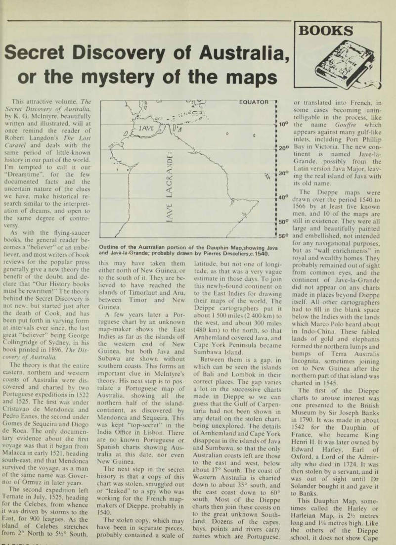
This Dauphin Map, some
times called the Harley or Harleian Map, is 2 Vi metres long and VA metres high. Like the others of the Dieppe school, it does not show Cape
Outline of the Australian portion of the Dauphin Map,showing Java and Java-la-Grande; probably drawn by Pierres Desceliers,c.1540.
York, Torres Strait or New Guinea. Well off the east coast of Jave-la-Grande is a large island, variously identified by “Believers” as New Caledonia, New Zealand, Furneax Islands in Bass Strait, or Tasmania.
Just pay your money and take
your pick.
Although everyone knew there was open sea to the south of Java, the Dieppe men eliminated this by raising Jave la-Grande northwards by about 4° of latitude, about 250 miles (400 km). I don’t know why this was done, for the new land could have been drawn in its correct latitude and in any longitude between America and Africa, or just below the islands of the East Indies withou touching any of them.
But having buried Arnhem land into Java, and Cape York into Subawa, they were faced with the problem arising from the voyage of Magellan around the world in 1522.
After Magellan was killed in the Philippines the survivors came down to the Spice Islands, and the flagship Vic toria sailed down to Timor, and then westwards, well south of Java. Mclntyre tells us that the Dieppe men drew a canal or river from the Gulf of Carpen taria to the west coast to allow the Victoria to pass through and called this canal the Rio Grande. Unfortunately, this superhuman work, like the Great Wall of China, was not a success, as the maps show the islands of Timor and Sumba to the south-east of their Sumbawa-Cape York so there should have been a canal
through that peninsula as
well.
The piece of Arnhemland- Java cut off by the canal is far too big for Java, but true be lievers can take that in their stride.
Mclntyre assures us several times that Jave-la-Grande is a very good map of Australia, and quotes many great authori ties who have seen the correct ness of the shape and detail of both east and west coasts. The 10 known Dieppe maps by the five different cartographers all
vary in shape, detail and nomenclature quite a bit, but that is understandable, like dif ferent witnesses’ drawings of
flying saucers.
Mclntyre says there is no need to pull the maps out of shape to make them look more like Australia as we know it, as many apologists and believers have done. He then proceeds to
do just that, by describing three
errors which insidiously pulled
the coastlines out of shape.
The first of these he calls magnetic Deviation, by which he means Variation of the compass due to the earth’s field. This pushed the east coast further and further east as Mendonca sailed southwards.
The next error is Erration, of which I had not heard before, and this is a further push to the east because of the map projec tion in use at the time.
The third error arose be cause the Dieppe men drew the chart on a paper-covered sphere, then sliced it into “quarters” like an orange and peeled it off. The resultant “gores” when laid out flat only touch in the tropics, and open out progressively north and south. When tracing the coast lines on to the final map the gaps in the lines were joined up and this resulted in Cape Howe (Cape Fremose on Jave-la- Grande) being charted I 500 miles (2 400 km) too far to the
east compared with Cape
York; in other words it arrives in about the modern position of Cape Howe. The western coastline does not receive any treatment, as no known or un known errors could pull that into the correct shape.
While Mclntyre was completing his book, another believer in the theory was at work on the Dieppe maps with a lot of cartographical skill and some scissors and paste. He is
Brigadier Lawrence Fitzgerald,
OBE, who was head of the
Army Survey Corps for many
years. He saw that the Dieppe men had to juggle a lot of dif ferent pieces of maps, about 12 in all, drawn on different scales and on unknown orientations.
By cutting up a copy of two ver sions of Jave-la-Grande, he
found that he could fit them together into a map of Aus tralia by changing the scales and tilting the coastlines around as necessary.
The Brigadier presented a paper to the Royal Historical Society of Victoria on the sub
ject in February, 1977, prob
ably too late for Mclntyre to give a mention of his work in the book. Only a skeptic or un believer could say that by using the same method one could produce a likeness to the map of Ireland, or a profile of our present Prime Minister.
Mclntyre’s book is packed
with excellent scholarship and research into the little-known
period of Portuguese su
premacy in discovery and navi gation right around the world.
Between 1500 and 1600 the best navigators were all Por tuguese, but many of their dis coveries were kept secret owing to the rivalry of Spain. There are photographs of four of the Dieppe maps, and of some of the well or less known relics which are proofs of Portuguese voyages on our coasts. Two of these figured in the Lost Caravel, the Tamil Bell and the
piece of Spanish helmet;
another two are in Victoria, the
Mahogany Ship at Warrnam
bool and the Geelong keys; then we have the carronades found in north-west Australia, and the broken stone walls near Twofold Bay, NSW.
Mclntyre asserts that our old friends, Torres, Tasman and Cook, all had knowledge of the Dieppe maps, in fact Cook had a copy aboard the Endeavour, kept in a secret drawer for his eyes alone. How else, after get ting his ship off the reef, could he have made straight for the Endeavour River? And when he reached it he wrote in his journal that the harbour was smaller than he had been told!
He was actually told about the harbour by an officer whom he had sent ahead in a boat to search for a suitable haven, while Cook remained at anchor for the night.
It is true that a good harbour is shown on the east coast of Jave-la-Grande, in about the right latitude, but that was just
south of Timor, and over I 000 miles (I 600 km) west of the present Cooktown. At the nearby Hope Islands, named by Cook because he was hoping hard that he would be able to save his ship, the steep, mountainous coast of Queensland is only four miles away. Mclntyre says that from these islands the coast is in
sight, but only just.
He also writes, while follow ing Mendonca’s track down the coast, that he sailed down from Cape York to Princess Charlotte Bay out of sight of land, quite regardless of the Great Barrier Reef. Then puts us right (?) by saying that the Barrier Reef begins at Cook town ! In some needless pass ages Mclntyre gives us an insight into Cook’s and Torres’ secret thoughts, and gives us conversations between Cook and Banks which are both unfounded and misleading.
The official Portuguese car tographer of the Indies, whose title was later confirmed by the King of Spain, was Manuel Godinho de Eredia, who is given a well-deserved place in the book. He was born in Ma cassar of a native mother, and so gained access to both Indonesian and Portuguese re cords. For many years prior to his death in 1623 he devoted his researches into trying to prove that the Portuguese were the first to discover Australia. But strangely he knew nothing of Jave-la-Grande, nor of Men donca’s great discoveries. He knew about the rich island of Zanzibar on the coast of Africa, in about the same latitude as Java, but he knew nothing of
the large fortified island called Zanzibar shown on the Dieppe maps due west of Perth.
The Dieppe map by Des celiers in 1550 shows the usual continent but without the name “Jave-la-Grande”, but perhaps there wasn’t room for that as the land is well covered with decorations; a coat of arms, two compass roses, trees, houses, pagans and cannibals, and four types of animal,
including elephants and
camels. There are also seven square cartouches containing information about other lands, Java, Sumatra, Zanzibar,
Ceylon, Malaya, Pegu and
“Anganie”. Not a word about Jave-la-Grande, nor is any mention to be found on any other maps, documents or in books.
Cook has been accused of making use of some of the
place-names on the Dieppe
maps, but as Mclntyre points
out, he was unlikely to do this intentionally, as that would have given away his secret pos session of one of the maps. The most quoted examples of these coincidences of names are (a) Cost des Herbaiges (Coast of Pastures), which became Bot any Bay: (b) Coste dangerouse for the Great Barrier Reef, and (C) R.de beaucoup d’isles, for the Bay of Islands. These are all very flimsy coincidences on which to make charges of plagiarism. The French and Portuguese names only occur on the east and west coasts, those on the north coasts are the correct Indonesian names belonging to Java and Sum bawa. We must remember that we only have Mclntyre’s word to assure us that the stolen Por tuguese map showed Amhem land and Cape York Peninsula, with a blank gap for the Gulf of Carpentaria.
In any case the last Dieppe
map is dated 1566. So that after the first appearance of Jave-la- Grande in 1541 to the last in 1566, it slipped back into the mists of the dreamtime, only to be seen at intervals, like the
“Flying Dutchman”, by the
true believers.
In conclusion, I must say that this fine book by a very learned and gifted writer forces us to believe that a small party of
map-makers in Dieppe, with
international reputations for being accurate and up to date, believed that an authentic copy of an original map of the newly charted land of Java Major had been stolen or “leaked” from the impregnable India Office in Lisbon.
The fact that they had obtained the copy fraudulently did not deter them from using it to improve the accuracy of their lovely world maps, made for an exclusive market, often as royal commissions. But how
honest was the secret agent in the India Office who made the map or copy and leaked it out for monetary gain?
Being nameless, his repu tation as a cartographer could not suffer, and if he had been caught by the authorities in Lisbon he couldn’t be charged with treason for selling a fic titious map to the French as a practical joke. We must admire his nerve and his wit, for his tilt at the French lasted for 25 years, and has kept echoing through the centuries. He could not have guessed that a serious book on his clever hoax would be written 437 year later, and in a city by the bay which he named Gouffre on his land of
Java Major!
Brett Milder
Pe Secret Discovery Of Australia: For
tuguese Ventures 200 years before Captain Cook.
By K. G. Mclntyre, published by the Souvenir Press (Australia) Pty Ltd. Adelaide. 59.95).