days of the RAAF in PNG
pp. 31-35 · Read in the full issue


Aloft with the Caribous: last days of the RAAF in PNG
From BRUCE ADAMS of RAAF Public Relations
“Moresby tower, Air Force 264 for Lae, eight persons on board, taxi clearance received Delta—Air Force 264, Moresby Tower, good morning, clear to Taxi time one three—Air Force 264 request clearance for take off.” The two engines burst into power, the aircraft roars down Jack son field, Port Moresby, and takes to the air.
Just another exercise for Air Force 264 in Papua New Guinea; just an other job. This time, the main job is to lift a border patrol from a small airstrip and settlement called Amanab, 13 miles from the Irian Jaya border and 60 miles from Vanimo, The aircraft is a Caribou, one of three attached to the Papua New Guinea Defence Force. They came originally from 38 Transport Squad ron, Richmond, NSW.
On board we have eight passengers, their destinations different towns and military garrisons throughout PNG.
There’s a crew of three, Flt-Lt Bob Winckel, PO Gordon Browne and the loadmaster, Daryl Millar. They have flown many missions in Papua New Guinea, the most difficult area in the world for light aircraft and small
transports to fly. Some of the areas should never have airstrips. It is amazing and quite frightening when you see them.
One, on the floor of an extinct volcano; one on a mountain-top 600 ft up; one in between two hills, with a 2,000 ft-drop at the end of the runway; one with a large humn in the middle of the airstrip; another with a very large slope. One could go on and on describing these airstrips. Two other quirks in New Guinea flying— inaccurate maps regarding heights of mountain ranges and peaks and pos sibly the worst of all, the heavy con centration of cloud build-ups.
As one pilot remarked, “We don’t worry about the clouds, it’s the rocks that are in them.”
The aircraft begins to climb, the morning sky is quite clear, our des tination is Lae, New Guinea. As we look down we pass over mile after mile of swamp country apparently in accessible; there are no villages or signs of life. We start to climb again, for now we are flying into mountain country with high peaks and cloud build-up. I chat to Bob Winckel on the intercom and ask him at what
Since 1965, three Caribou aircraft have been operating with the Papua New Guinea Defence Force, around Papua New Guinea, around New Ire land, New Britain and Bougain ville, manned by mixed crews from 35 and 38 Squadrons.
Operating in all kinds of weather, without radar and fly ing by visual aids, over the most difficult country in the world, the Caribou detachment has an exceptionally high flying record. In 10 years they have lost only three aircraft, trans ported thousands of personnel, thousands of tons of cargo, given civil aid to famine areas and rescued hundreds of people.
Now it is finished. The Caribous and their crews flew back to Australia for good just before Christmas.
height we’ll level off. His reply is, “11,000 ft,” and explains, “Mount Yule is about 10,500 ft, and that would be the highest mountain in this area.”
The clouds begin to build up and our visibility is becoming limited. We dod»e in and out of the clouds. Sud denly Bob Winckel tells me to look out to the right and there, sitting a few feet above a large cloud, is the mountain peak, black and dominating the white clouds with a sinister effect upon the whole scene.
Shortly after passing Mount Yule we make a landing at a place called Guari, on the top of a mountain, an airstrip 1,800 ft long and 6,000 ft above sea level.
Only an aircraft like the Caribou with a STOL performance could land and take off from an airstrip like this.
Once airborne off the edge, there is no turning back; you either fly down the valley or into the side of a moun tain. In actual fact, the clouds are practically level with the airstrip.
Half-an-hour later we pass over Bu- Jolo, and as we do, we see the great gdd dredges which were flown in piece by piece by the old Junkers air craft in gold rush times in the 1920- 30s. Today, some of them lie rusting and rotting.
Then, on down to Salamaua and finally Lae. The weather has been good to us, hardly any cloud for most of the trip.
After an hour on the ground at Lae, when we refuel, take aboard some more freight and passengers, we take off once more, this time for
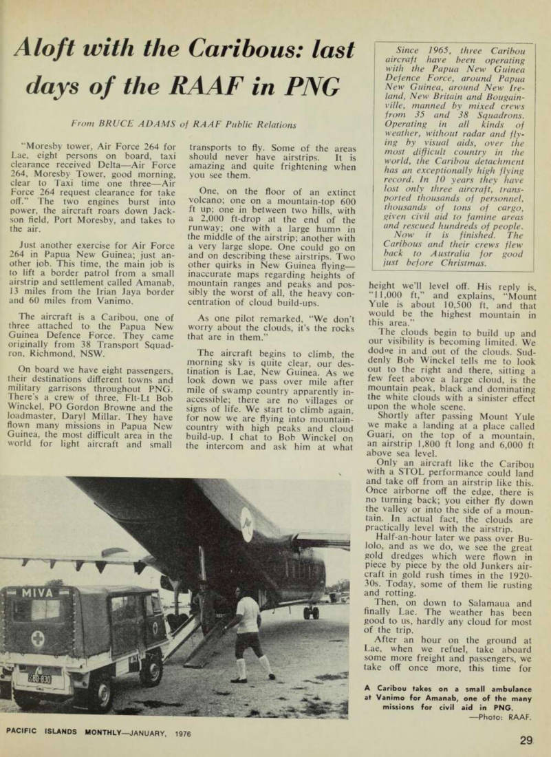
A Caribou takes on a small ambulance at Vanimo for Amanab, one of the many missions for civil aid in PNG.
Photo: RAAF.
Wewak, and we start the long haul up the Markham and Ramu valleys.
At 500 ft we can see the crazy, winding path of the Markham River, and some of the old wartime revet ments and airstrips which constituted one of the biggest air bases on the New Guinea mainland 30 years ago.
Today, the valley is extensively farmed and cattle-breeding is pre dominant.
Once out of the Markham and Ramu, the clouds build up; we dodge and weave and find holes in them; small rain squalls start; the sun starts to make an appearance; it’s gone once more, now the heavy rain, and the Caribou flies on through it all.
Late in the afternoon we arrive at Wewak. Here the aircraft is unloaded and the crew lock the aircraft and secure it for the night.
Next morning is bright and clear as we fly out of Wewak. The Cari bou maintains an altitude of 500 ft just after take off. On our starboard side can be seen the islands of Mushu and Kairiru. We can see for miles ahead as we fly off the coast; the water is blue and clear off-shore. On the way up the coast, we pass old wartime airstrips plastered with bomb craters, places like But, Dagua, Aitape, Tadji, some still containing old wartime aircraft wreckage. Others, the jungle is reclaiming. After an hour and a half, Vanimo comes into sight, a beautiful small settlement tucked away in a bay with heavy jungle-clad hills sweeping down to the foreshore. It is here that the Pacific Islands Regiment has one of its garri sons.
Once on the ground, the pilots and the Loadmaster hand-pump the fuel.
A small ambulance is loaded for the mission hospital in the area.
After it has been securely chained to the floor of the aircraft we take off. The country is hilly and heavily limbered with tall trees, with small winding rivers, and dense swamp country, a place where you wouldn’t like to make a forced landing.
After 30 minutes flying time Amanab can be seen, a small airstrip surrounded on both sides by houses.
As we fly in the pilot makes a sharp left-bank, and lands. The dust settles as the Caribou comes to a standstill and the rear loading ramp is opened.
The pilots are greeted by two offi cers, Lieutenant Geoff Key, leader of the border patrol, and a European officer, Captain Gary Parker from an engineering company in Port Moresby. The patrol has been out for two weeks, in which time they have covered 120 miles, their best being 18 miles in one day. On their patrol they had helped the local population by repairing buildings, renewing
bridges, confirming locations of tracks, and seeing if any medical care w -- eded - f inn , Within a few 100 yards of the aircraft strewn around the area were piles of water bottles, webbing belts, rifles, packs, and to one side, several of the patrol members playing cards.
There are 25 members of the patrol plus the two officers. By this time there’s a large gathering of locals, many young children, a few European missionaries and the local district officer. The small ambulance is unloaded, and driven away by one of the hospital staff.
Off we go again then, with the patrol on board as the last rays of the sun streak across the sky the Caribou touches down on Vanimo airstrip.
Next morning, more fuel is handpumped into the aircraft; more cargo is loaded. No matter where they fly in New Guinea, the Caribous never fly empty.
An hour and a half later we are at Wewak once more, this time to pick up fresh vegetables for the Army and Navy at a place called Wapenamanda, not far from Mount Hagen. We fly in, down the floor of the valley, to Wapenamanda. As far as one can see there are vegetable gardens, in neatly-kept rows. On arrival we are surrounded by the locals who come down from the hills to see the weekly Caribou. The aircraft is loaded to its maximum weight with fresh lettuce, onions, carrots, spring-onions, pota-
toes, cabbages, and many other vege tables.
Then, off and over the Sepik Plains, where we encounter a tropical storm The Caribou is thrown around like a piece of match-wood. Daryl Millar the loadmaster, checks all his straps’
Visibility is nil, the Caribou doesn’t have weather radar, the flying is all visual. The two pilots are trying to keep the aircraft straight and level, Lightning streaks across the sky. We hit one part where the aircraft is vio lently buffeted and it drops about 40 feet. Bob Winckel tries to contact Wewak control, but, so far, he is unable to do so.
Water starts to run down inside the fuselage. In the cockpit it is dripping everywhere; on both the pilots, near the radio equipment and on the con trol panel, We are about 15 miles from Wewak when Bob Winckel makes radio con tact. The news is not good. The storm is worse over Wewak, visibility is nil and the cloud ceiling is down to about 100 ft. Their advice is to ride out the storm, and by the time we are over Wewak nothing can be seen except rain beating down on the cockpit canopy.
The wipers are not fast enough, Somewhere beneath us is Wewak, and the coastline of Ne*v Guinea. We are now doing circuits over the area. Bob Winckel checks the fuel gauge, we still have plenty. We are now down to 500 feet and hoping to see a break in the clouds. He opens the small
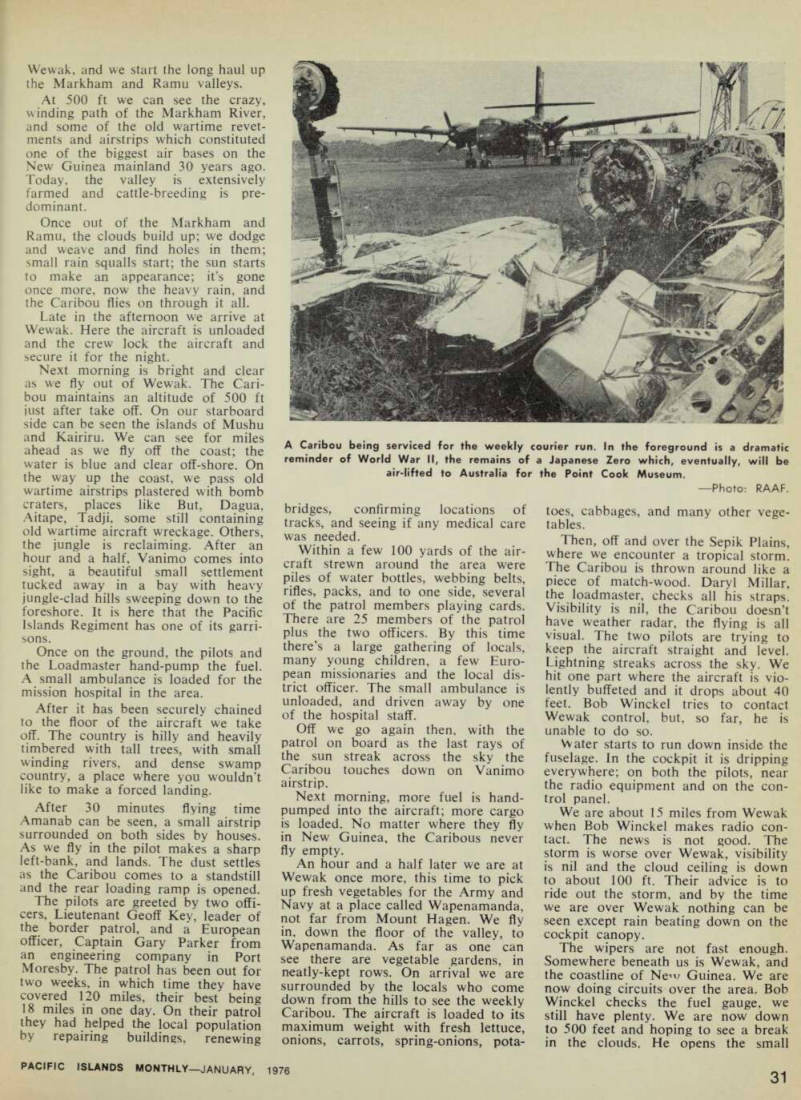
A Caribou being serviced for the weekly courier run. In the foreground is a dramatic reminder of World War 11, the remains of a Japanese Zero which, eventually, will be air-lifted to Australia for the Point Cook Museum.
Photo: RAAF.
pilot’s window. The rain beats on his flying suit and helmet. He screeches out, “It’s there.” A very small break in the clouds and we can just see Wewak. Down to 300 ft and we make for the break, his window still open.
Two hundred feet 100 feet, and there it is, the airstrip. We touch down in a large spray of water. The ram is so heavy that the hangars cannot be seen from the runway.
Halt an hour later the storm has gone, and the sun shines once more.
The aircraft is unloaded and refuelled fly o^ove“he d Spik P y |ai B ns down the ny out over me riains uown me Ramu Valley, and the Markham into Lae The weather is perfect all the ine weamcr is pcrieu di me way and the flight is uneventful.
From Lae we make for Port Moresby, across the Owen Stanley Ranges. It is now about four o’clock in the afternoon, and some small clouds are beginning to build up over the Huon Gulf. We leave the New Guinea coastline and head into the interior of Papua to cross the Owen Stanleys. Once in the mountainous area the clouds begin to build up and take the form of dark black shapes. Behind us the clouds are clos-
ing in, we can’t go back, only forward. We pass through a few light rain squalls. Then the cloud is all around us. We begin to climb, 5,000 ft, 8,000 ft 10,000 ft, the crew put on their oxygen masks.
Still the c i OU( j sur rounds the aircra ft There is no visibility, we climb once more to 12,000 ft. There is nothing to identify as a map reference point. We change course, all the time looking f or a break in the clouds. the Su c^ ly b / ne s a 7 h al^
ft It ‘Jhe'floor of
’ f prp ’ „ rp taVpn wp J* ma P references are taken as we tty along the valley. We find we are 15 p w , t . . miles on course, we cant go back, so the new flight plan is to head for the Popondetta area. The clouds hang heavily around us, but here and there are small gaps.
The aircraft dodges in and out of the gaps. A few miles away to starboard is the dark outline of a mountain range. We can’t climb because of the heavy cloud above us. We descend to 5,000 ft to try to identify some landmarks; the pilot gets his bearings. Ahead of us the clouds are
beginning to get heavier. Up again to 10,000 ft. This time we pass over the top, down again, in and out of the gaps.
Then comes a large break in the clouds, and miles ahead we can see the ocean, and the coastline of Papua, We dive down to 1,000 ft and track along a small river. In the distance, over the Coral Sea we can see large storm clouds heading our way.
Twenty minutes flying time and we nrp , ftVpr ran? w/o qtp n fl ' ,ins at 50 « ft al °ng’ the coastline,
fading Po . rt The /ff
starts to beat down heavily and the , . u/hirh W p r p r>vpr the* fnr^i clouds which were over the Coral Sea are beginning to catch up with It • , tp ft „ . thp ,• ht H s * *.* at ® aft e ™° on ’ and the h e ht K Bob Winckel makes contact with Moresby control. The weather over Moresby is perfect. Twenty minutes l ater Moresby is sighted and the Cari kou start l.. to descend, the sky over Jackson Field darkening as the last rays of the sun disappear behind the Owen Stanleys.
“Moresby Tower Air Force 264 from Lae, request clearance to land.”