Take A 'Chopper' For A Stroll
pp. 43-47 · Read in the full issue
In The Bougainville Bush
From JOHN ECCLES, in Bougainville
Bougainville has all the tourist potential any island could wish for.
Its interior has the rugged mountains and volcanoes one associates with the New Guinea mainland and its coast is as tropically peaceful as any other South Sea island.
However, it still has a poor road system and no hotels or guesthouses at all outside the main centres of Kieta, Buin and Buka Passage. While it has the best piece of road in the country, between Loloho and the Panguna copper mine, it also has the very worst roads that can be seen anywhere.
Despite all its potential, therefore, Bougainville has hardly been touched by the tourist. He visits Kieta for its lovely bay, Buin for its war relics, Panguna for the mine and Buka Passage for the fishing—and that would be considered a full tour.
Two beautiful spots he would miss completely—Torokina, under the watchful brow of active Bagana Volcano, and Wakunai on the other side of the island, approachable only by foot or by air. You really see Bougainville at its best by foot—the plantations of the coast, the jungle and volcanoes of the interior and the
trail, ending at Numa Numa near Wakunai, which became famous during World War 11.
I flew in to Torokina with fellow BCP worker Ken Philips by chopper from Panguna. The alternative would have been a marshy walk along the western plains for two days. World War II dealt harshly with Torokina, but there is little to show for it now.
The Banoni Mission, run by Dutch Father Saris, nestles by the old coastal airstrip. Up the road is the Piva Leper Hospital, run by the Sisters of Mary, the only one of its
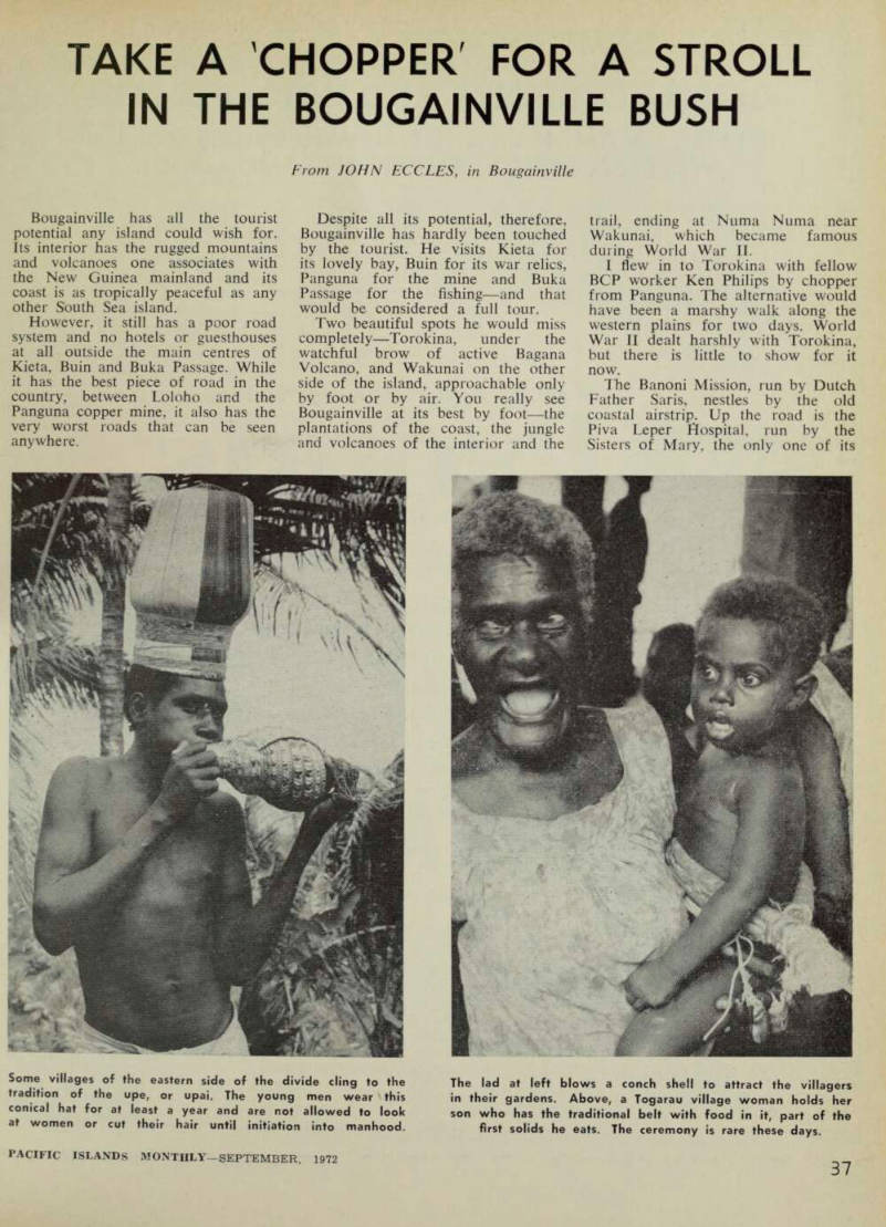
Some villages of the eastern side of the divide cling to the tradition of the upe, or upai. The young men wear this conical hat for at least a year and are not allowed to look at women or cut their hair until initiation into manhood.
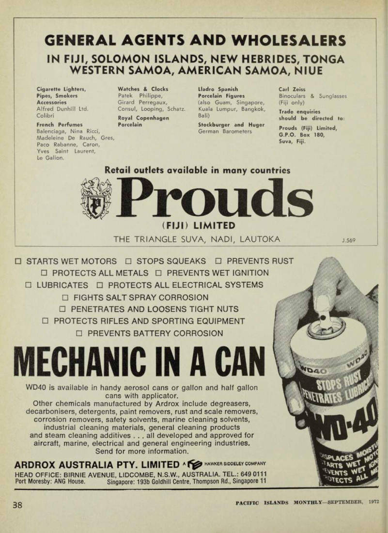
The lad at left blows a conch shell to attract the villagers in their gardens. Above, a Togarau village woman holds her son who has the traditional belt with food in it, part of the first solids he eats. The ceremony is rare these days.
A little war history uncovered by development
kind on the island. The plains leading up the mountains are dotted with villages and on the coast near the mission is Dokotanama village, the people of which once lived on nearby Puruata island until it was flattened during the war.
Torokina in November, 1943, was the last place the occupying Japanese expected the Americans to attack.
The US Marine landing there was a fairly easy matter. Only 78 Marines were killed and 270 of the enemy.
The Americans sent a Fijian battalion to Ibu on the other side of the range to watch the Japanese at Wakunai. The trail was the same we were about to use. When the Japanese counter-attacked early in 1944, the Fijians retreated to Torokina.
Over 20,000 Japanese attacked the American garrison; 5,000 were killed and 3,000 wounded were carried back to Wakunai over the Numa Numa trail. It was the last Japanese offensive in the Solomons area.
The Australians took over Torokina in October, 1944, and began offensives immediately. When the Japanese surrender came they had control over most of the Numa Numa trail and were ready to strike at Wakunai.
Today there is little left of the war; salvage operators have cleared the wreckage. But one of the air strips has been cleared by a private contractor, Ray “Kiwi” Blanchfield, and DCA permission has been given to open it again.
We followed the road across the Torokina plains to the foot of the dividing range under the shadow of the volcano and there the walk started. The Numa Numa trail follows the Laruma River through a gorge and then straight over the range.
Another branch crosses the range diagonally going very close to the Balbi volcano. We had to take the Balbi route as the Laruma was in flood and we couldn’t cross.
It was a sunny morning when Ken Philips and I set out with the porters.
As we climbed the cloud dropped accordingly until the familiar rain began to come down. Walking the Bougainville ridges in pouring rain, sliding mud and tripping vines, is a lousy way to spend a day. But it’s great afterwards sitting in the warmth of a bush hut with a billy boiling and a tin of corned beef heating over the fire.
I just kept thinking about that boiling billy as we trudged up and down, up and down. For those who fought here during the war, every ridge may hold a memory. To us, every ridge looked the same—
horrible. No war relics, not even a village to drop into and have a coconut.
Ten hours we walked that day, just making it to a deserted bush hut as the light began to fail. We were within two hours of the top of the divide—not a bad effort considering we had to detour round the Laruma River. Crammed into the bush hut watching the fire boil our billy, we asked our guides what to expect tomorrow; “I go, i go, i go,” they said, “i long way liklik”.
Not knowing whether to feel pleased or dejected, I fell asleep.
Next day we were off at dawn, swigging away at mugs of tea as we went. Two hours later we crossed the divide and saw Balbi for the first time. It’s a beautiful volcano made up of a series of craters rather than the classical one. Sisivi, the first village over the divide, is perched on a ridge separated from the volcano.
It seems to float in mid air with Balbi soaring 5,000 ft higher.
No-one is quite sure how high Balbi is. The maps say 8,500 ft but nearer 10,000 would be closer. Quite a few groups from BCP climb the volcano by bush path. There is no
Solid food singsing
thermal activity at the top but there are sulphur pools.
Few people were about when we reached Sisivi as they had gone to a singsing, so we continued on towards Togarau where we hoped to spend the night. The next village, Ruruvu, had fine pomeloes (a sweeter grape fruit, with thicker rind), and we gratefully quenched our thirst on them. On to Togarau, perched up a 500 ft bluff. There we found the singsing being held to celebrate the eating of solid food by some of the village babies.
The babies were wearing large vine belts round their waists with a protuberance at the side. The pro tuberance held morsels of food con nected with the eating rite, spiced with bush herbs to make the babies strong. There was no alcohol at this singsing in the heart of Bougainville, a pleasant change from the more “civilised” parts of the island.
One of the villagers was a friend of Ken’s and invited us to stay the night. We dined on potatoes with a tin of corned beef neatly tipped on top. Togarau has a rich volcanic soil which grows many crops superior to the rest of the island. A road is slowly being built from the eastern side of Bougainville towards the village. When it arrives, the villagers hope to make a good living selling garden produce to the Wakunai area.
From Togarau an easy walk followed the Wakunai River down to the coast near the Marist Mission of Asitavi.
The next day we walked through village gardens for an hour before striking the river. The new road follows the river too and it was a pleasant respite from ridge walking to follow its smooth surface, taking the occasional cooling dip in the river.
By 2 p.m. we were at Asitavi where Fr Kronenberg put us up for the night. The area has numerous plan tations, many of them dating back to German times. Oldest is Numa Numa itself, started in 1912 by Buka Plantations and Trading Company.
It’s also the country’s largest single plantation, at 4,000 acres. In charge since 1934, bar the war years, is Sandy Sandford, well known for his part in guerilla operations against the Japanese. Sandy’s wife runs a trade store and Sandy spends his spare time looking after his beloved orchids.
So there it is, a tough, but rewarding walk across Bougainville.
It shouldn’t be attempted without letting the local administration know, or, in the case of Bougainville Copper people, the village relations officers.