Marking P-Ng/West Irian Border
pp. 68-74 · Read in the full issue

Is A Surveyor's Nightmare
By A. J. Ludbrook
Australia has only one international border—that between Papua-New Guinea and West Irian. Yet, despite the fact that at various times in the past half-century attempts have been made to define this border, it was not until 1966 that serious work was done to mark it.
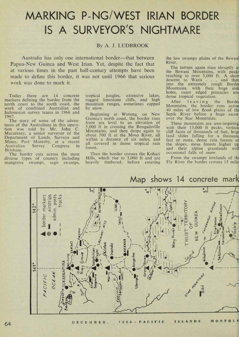
Today there are 14 concrete markers defining the border from the north coast to the south coast, the work of combined Australian and Indonesian survey teams in 1966 and 1967.
The story of some of the adven tures of the Australians in this opera tion was told by Mr. John C.
Macartney, a senior surveyor of the Department of Lands, Surveys and Mines, Port Moresby, at a recent Australian Survey Congress in Brisbane.
The border cuts across the most diverse types of country including mangrove swamps, sago swamps,
tropical jungles, extensive lakes, rugged limestone cliffs, and high mountain ranges, sometimes capped by snow.
Beginning at Wutung, on New Guinea’s north coast, the border rises from sea level to an elevation of 5,000 ft in crossing the Bougainville Mountains, and then drops again to about 500 ft at the Moso River, all within a distance of six miles, and all covered in dense tropical rain forest.
Then the border crosses the Kohari Hills, which rise to 3,000 ft and are heavily timbered, before entering
the low swampy plains of the Bewani River.
The terrain again rises abruptly ir the Bewani Mountains, with peakj reaching to over 5,000 ft. A shorl descent to Waris . , . and ther into the extremely rough Bordei Mountains, with their huge sinli holes, razor edged pinnacles anc dense tropical vegetation.
After leaving the Bordei Mountains, the border runs acrosj 40 miles of low flood plains of the Sepik River before a huge ascen over the Star Mountains.
These mountains are awe-inspiring with their 13,000 ft peaks, vertica cliff faces of thousands of feet, huge land slides falling for a thousanc feet or more, dense rain forests oi the slopes, moss forests higher up and their alpine grasslands will occasional falls of snow.
From the swampy lowlands of the Fly River the border crosses 15 mile:
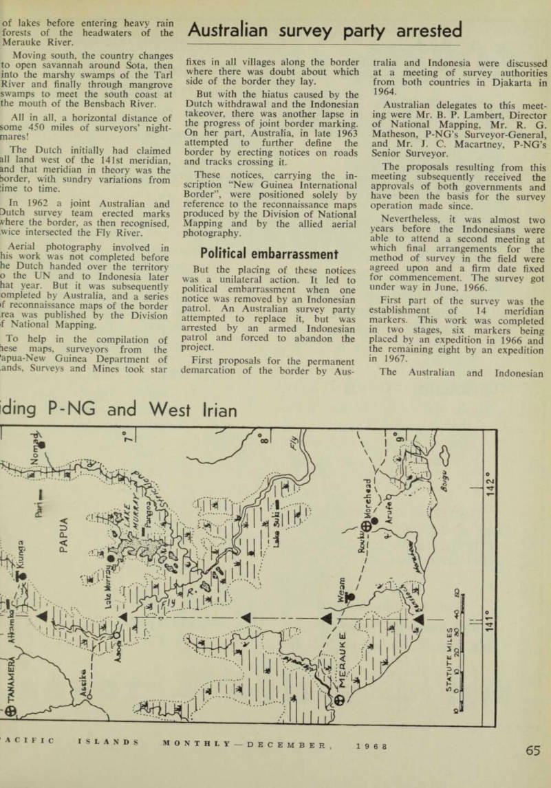
Map shows 14 concrete mark
of lakes before entering heavy rain forests of the headwaters of the Merauke River.
Moving south, the country changes to open savannah around Sota, then into the marshy swamps of the Tarl River and finally through mangrove swamps to meet the south coast at the mouth of the Bensbach River.
All in all, a horizontal distance of some 450 miles of surveyors’ night mares!
The Dutch initially had claimed all land west of the 141st meridian, and that meridian in theory was the ?order, with sundry variations from :ime to time.
In 1962 a joint Australian and Dutch survey team erected marks vhere the border, as then recognised, wice intersected the Fly River.
Aerial photography involved in his work was not completed before he Dutch handed over the territory o the UN and to Indonesia later hat year. But it was subsequently ompleted by Australia, and a series if reconnaissance maps of the border rea was published by the Division f National Mapping.
To help in the compilation of lese maps, surveyors from the apua-New Guinea Department of ands. Surveys and Mines took star
Australian survey party arrested
fixes in all villages along the border where there was doubt about which side of the border they lay.
But with the hiatus caused by the Dutch withdrawal and the Indonesian takeover, there was another lapse in the progress of joint border marking.
On her part, Australia, in late 1963 attempted to further define the border by erecting notices on roads and tracks crossing it.
These notices, carrying the in scription “New Guinea International Border”, were positioned solely by reference to the reconnaissance maps produced by the Division of National Mapping and by the allied aerial photography.
Political embarrassment
But the placing of these notices was a unilateral action. It led to political embarrassment when one notice was removed by an Indonesian patrol. An Australian survey party attempted to replace it, but was arrested by an armed Indonesian patrol and forced to abandon the project.
First proposals for the permanent demarcation of the border by Aus
tralia and Indonesia were discussed at a meeting of survey authorities from both countries in Djakarta in 1964.
Australian delegates to this meet ing were Mr. B. P. Lambert, Director of National Mapping, Mr. R. G.
Matheson, P-NG’s Surveyor-General, and Mr. J. C. Macartney, P-NG’s Senior Surveyor.
The proposals resulting from this meeting subsequently received the approvals of both governments and have been the basis for the survey operation made since.
Nevertheless, it was almost two years before the Indonesians were able to attend a second meeting at which final arrangements for the method of survey in the field were agreed upon and a firm date fixed for commencement. The survey got under way in June, 1966.
First part of the survey was the establishment of 14 meridian markers. This work was completed in two stages, six markers being placed by an expedition in 1966 and the remaining eight by an expedition in 1967.
The Australian and Indonesian
ding P-NG and West Irian
They used the stars
teams were equally balanced in numbers. Each team, headed by a survey officer, included labourers for clearing, an administration officer for liaison with local population, medical personnel, and four security men, consisting of one commissioned officer and three others. The teams were even in number.
But first a joint reconnaissance team made an aerial inspection and selected sites as near as practicable to the meridian at which the astro nomical observations would be made.
The sites were selected on major rivers at the approximate latitudes agreed upon at the 1964 Djakarta ueeting.
The river sites were chosen for leveral reasons—easy initial access >y helicopter landing on the river )ed, availability of drinking water or the survey teams, and also water md materials to construct the oncrete markers. Further, move aent of people in these areas is aainly along the rivers.
It was the job of the clearing arty to go into a proposed site and repare a helicopter landing area, rect a full camp and clear a site ar astronomical observations.
The security men and liaison fficer made the initial contact with >cal people in the area.
Concern
At one site the locals had never sfore seen white people and the nding of the helicopter plus the hites caused them some concern.
The procedure was, first, for a earing party to be landed by heli >pter on a suitable place in the bed : the river, the party then to pre ire nearby a helicopter pad with e aid of chain saws (the helicopters metimes had to descend vertically ;tween trees hundreds of feet tall), le camp site was then cleared, the mp erected, and finally the astro >mical observing site was cleared.
Thus the survey parties leap 3gged their way down the border.
Independent astronomical observa >ns were made by both teams tablishing the border. Each team ade its observations at separate ints, theoretically on its respective le of the meridian.
The teams then traversed to a mmon point, where their results ;re compared and averaged, if they reed within the prescribed limits of :uracy.
If the results differed too much ;n the position of the point was be re-determined by both sides
until the results agreed within the prescribed limits.
Both teams were free to select their own observational methods and stations for radio time signals.
The Indonesians at one stage were working by an observation method of using stars which they could visually identify from a star chart.
As there were seldom large areas of clear sky, this method proved diffi cult.
Finally they accepted the offer by Australia to supply them with electronically pre-computed star pre dictions.
After the completion of observa tions during the 1966 expedition the data was forwarded to Canberra, where it was processed through the CSIRO computer. The results were radioed back to NG, and the full printed computer output was mailed back.
In the 1967 expedition the Aus tralian surveyors processed their observations in the field.
Construction of the concrete monuments on the meridian was always a joint effort, with both teams providing manpower and materials.
"Happy occasions"
“These were always happy occasions on the survey, for although the work was arduous the sense of achievement of completing another mark overrode the physical dis comfort,” Mr. Macartney says.
After the placing of the marks at each station, white cloth strips were laid about the marks in the form of a cross and the marks photographed from the air at heights of 300 ft, 1,300 ft, 3,000 ft, and 10,000 ft.
This was done for identification on survey photography previously flown at 25,000 ft.
Said Mr. Macartney: “The taking of these photographs was a thrilling experience, particularly from 10,000 ft with no door on the helicopter and leaning out with a camera weighing 15 lb.”
Mr. R. G. Matheson, the terri-
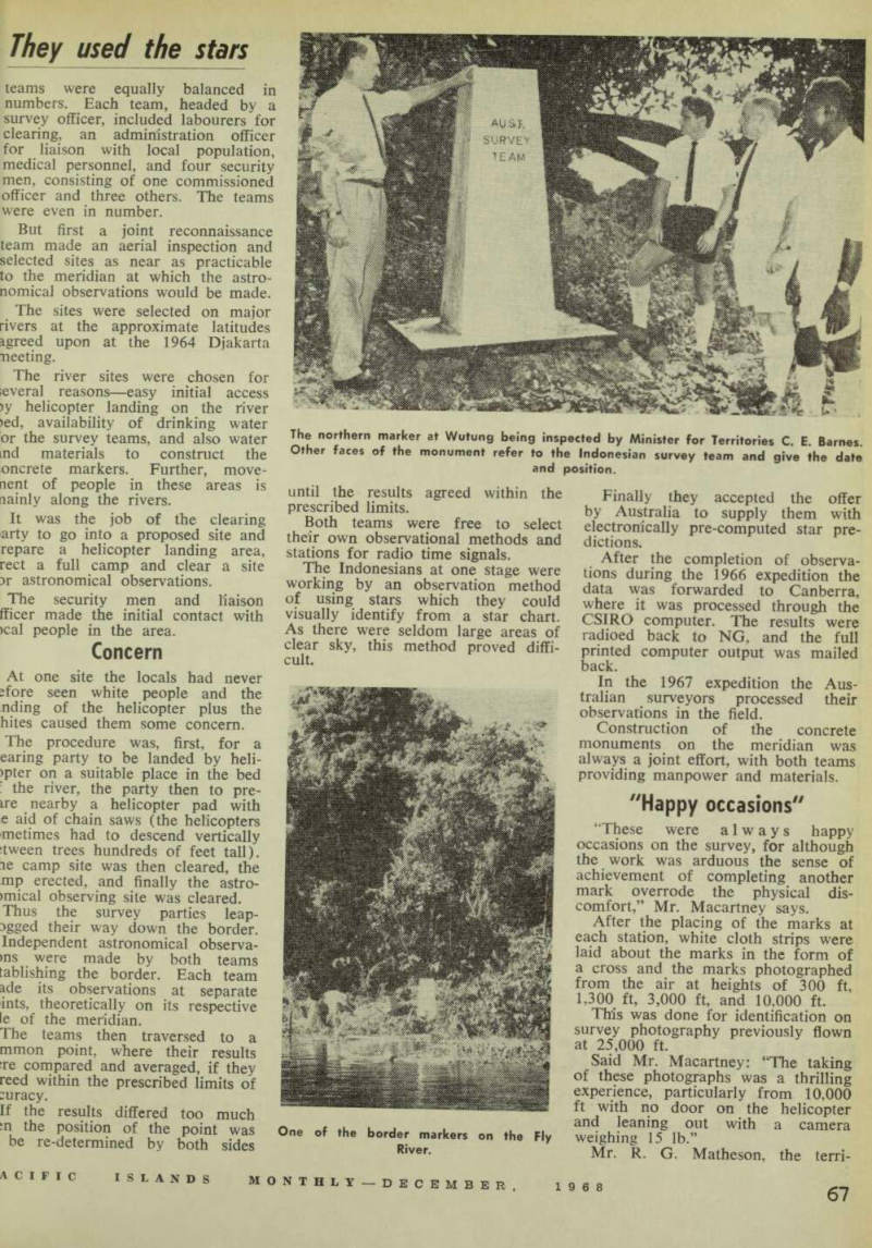
One of the border markers on the Fly River.
The northern marker at Wutung being inspected by Minister for Territories C. E. Barnes.
Other faces of the monument refer to the Indonesian survey team and give the date and position.
Rations ran out
tory’s Surveyor-General, in an addendum to Mr, Macartney’s paper, said that before the 1964 Djakarta conference, Australian work on the border was made under “considerable hardship”.
There were no helicopters. Long patrols through the jungle carried a minimum of camping equipment and the bare necessities in instruments and radio equipment.
The situation changed radically when the international project was planned. There was an abundance of equipment.
The Indonesian surveyor in charge was Dr. J. Soenarjo, principal of the School of Astronomical Surveying in Bandung. He was assisted by pupils about to graduate from that school.
Just prior to the end of stage two of the survey, Dr. Soenarjo accepted a position in Saudi Arabia, and was replaced by Captain Tawil.
“The Indonesian surveyors proved accurate and efficient,” said Mr.
Vfatheson. “The spirit of co-opera ion exhibited by them at all times vas a major contribution to the ;uccess of the project.
“Our officer in charge, John Macartney, proved an ideal choice or this task because of his under tanding of the fairly sensitive liplomacy required in such an opera ion.
Diplomatic success
“This was probably the first serious :>int project by Australians and ndonesians, and was in an area 'here some embarrassment at iplomatic level had occurred. We re proud that the operation proved n important diplomatic success.”
Only the weather was not always ind. An example was when the bserving teams, Indonesian and Australian, were left at 12,000 ft in le Star Mountains for three weeks ecause weather prevented the return f the helicopter.
It arrived the day the emergency itions ran out!
Mr. Matheson added: “The work does not end the survey. There still the major task of linking up iese 14 points over some of the ost difficult country in the world, hen we are faced with the main nance and preservation of the arks against tropical jungle, winds id snow, and annual floods.
“There is not much chance of irveyors working themselves out of job in New Guinea.”
HM