highway to
pp. 51-53 · Read in the full issue
How they built New Guinea's fabled highway to the Highlands
From AAP-Reuter and PIM correspondents in Lae Papua-New Guinea’s Road to the Highlands is daily taking more traffic, as visitors discover its potential. Tourists are finding that it will get them to the interior along a more picturesque route. The fabled highway is having its effect on the territory in other ways, too—for instance, trade through the seaport of Madang has dropped by 23 per cent, this financial year because cargo is now being road-hauled to the Highlands from Lae along the Highlands Highway. Once most of this cargo was airfreighted from Madang.
It has been estimated that 300 vehicles a day, most of them commercial, are using the highway today.
“The road they built a million years too soon,” “a death trap,” “a magnificent engineering feat,” “the home of a Masalai (evil spirit)”— that is the 350-mile Highlands High way, as it has been described.
The highway, in many places only a 12 foot wide ribbon of uncrushed river gravel, winds around jagged mountain peaks of up to 14,000 feet.
It also links the 850,000 people of New Guinea’s Highlands with the major northern port of Lae, and it is a growing attraction for tourists.
And along it the products of the primitive Highlanders coffee, tea, beef and pyrethrum—are now wind ing their way towards the markets of the world.
Administration officials had wished to build the highway for many years.
But attempts to find a route down precipitous Mount Kassam to the lowlands 100 miles from Lae were always frustrated.
In the early 1950’s a young Native
Affairs Officer, Gerry Toogood, now a senior Administration official, be ban a bid to find a route.
He met prospectors, cattle pioneers and village chiefs in his search for clues. He walked over every stock route, hunting pad or track to see if they could be enlarged.
"Impossible"
At last he settled on an old stock route—which wound down the heavily-timbered, torrent-laced mountainside at an average gradient of one-in-three.
Ignoring widespread claims that the project, without proper equip ment and strong financial backing, was impossible, the route was pegged out. Toogood recruited hundreds of villagers—men, women and children —whose only tools were wooden spades.
The Eastern Highlands District Commissioner of that day, Mr. lan
Downs told the Administrator, Sir Donald Cleland: “Sir, give me 300 shovels and six months and I will link Goroka with the coast”.
Downs placed a 21-year-old cadet patrol officer, Rupert Haviland, in charge of the road. His problems were immense.
In a race to beat New Guinea’s torrential “wet”, bridge decking to span the chasms through which the streams raged to the plains were hacked from the bush by the light of bonfires or pressure lamps. Pack horses and mules were needed to bring food and equipment to the workers.
But the worst problem was the area’s geological immaturity.
The region’s unstable rivers were likely to change course overnight.
The clay turned to slimy red ooze after rain, the highly-decomposed rock was likely to crumble.
As the director of the Common wealth Department of Works, Mr.
Jock Cameron, said later, it was the road they built “a million years too soon”.
But in mid-1953 the Kassam Pass road was open.
Much more had to be done before the Highlands road was a reality.
The roadhead was still far from Mount Hagen, the main centre of
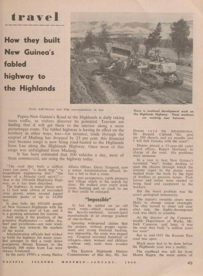
There is continual development work on the Highlands Highway. These machines are working near Kainantu.
the Western Highlands. Between was cloud-capped Mount Daulo.
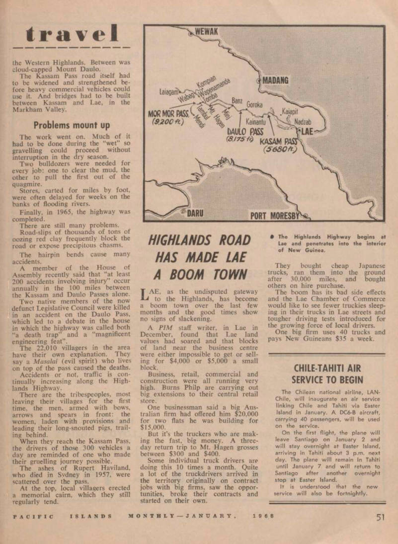
The Kassam Pass road itself had to be widened and strengthened be fore heavy commercial vehicles could use it. And bridges had to be built between Kassam and Lae, in the Markham Valley.
Problems mount up
The work went on. Much of it had to be done during the “wet” so gravelling could proceed without interruption in the dry season.
Two bulldozers were needed for every job: one to clear the mud, the other to pull the first out of the quagmire.
Stores, carted for miles by foot, were often delayed for weeks on the banks of flooding rivers.
Finally, in 1965, the highway was completed.
There are still many problems.
Road-slips of thousands of tons of oozing red clay frequently block the road or expose precipitous chasms.
The hairpin bends cause many accidents.
A member of the House of Assembly recently said that “at least 200 accidents involving injury” occur annually in the 100 miles between the Kassam and Daulo Passes alone.
Two native members of the now defunct Legislative Council were killed in an accident on the Daulo Pass, which led to a debate in the house in which the highway was called both “a death trap” and a “magnificent engineering feat”.
The 22,010 villagers in the area have their own explanation. They say a Masalai (evil spirit) who lives on top of the pass caused the deaths.
Accidents or not, traffic is con tinually increasing along the High lands Highway.
There are the tribespeoples, most leaving their villages for the first time, the men, armed with bows, arrows and spears in front: the women, laden with provisions and leading their long-snouted pigs, trail ing behind.
When they reach the Kassam Pass, the drivers of those 300 vehicles a day are reminded of one who made their gruelling journey possible.
The ashes of Rupert Haviland, who died in Sydney in 1957, were scattered over the pass.
At the top. local villagers erected a memorial cairn, which they still regularly tend.