relic of “lost” Spanish city of 1606
pp. 14-156 · Read in the full issue
New Hebrides jungle find may be relic of “lost” Spanish city of 1606
By Robert Langdon
A mysterious stone wall, which may be a relic of a Spanish expedition to the Pacific of 360 years ago, has been found in dense tropical bush on the island of Espiritu Santo, New Heb rides.
THE wall is near the coast of Big Bay, about three miles east of the River Jordan, where an expedition under Captain Pedro Fernandez de Quiros, a Portuguese by birth, founded the city of Nueva Jerusalen (New Jerusalem) in May, 1606.
No traces have previously been found of this city, which was the second earliest attempt at European settlement in the South Pacific. (Men dana, in the Solomons, was first in 1595).
Thus, if the wall was part of New Jerusalem, it is a discovery of major historical interest.
The appearance of the wall suggests that it originally formed part of a stockade, which the Spaniards are known to have built to protect themselves against the hostile natives of the area.
In the days of Quiros, the country in the vicinity of New Jerusalem was thickly inhabited. But diseases have since decimated its population.
Today it is an empty, lonely land, seldom visited either by Europeans or New Hebrideans. It is for this reason, and because of the dense vegetation, that the wall has escaped detection for so long.
The wall was discovered in January by a 36-year-old Australian, Mr. Ted Hebblewhite, of Sydney.
Collecting copra
Mr. Hebblewhite was then work ing for Burns Philp and Co. in the town of Santo, and had trekked some 25 to 30 miles across the Sakau Peninsula of Espiritu Santo to Big Bay on an errand for his firm. (See map p. 15.) His errand was to try to intercept the Burns Philp trading ship Trudy, which was collecting copra in the bay, but which was required for an urgent charter job in Santo.
Mr. Hebblewhite, who has now returned to Australia, casually men tioned his discovery of the wall to me in Sydney in late February after I had met him several times.
For fear of being “made a goat”, as he put it, he had not intended to say anything publicly about it until an American archaeologist, Dr.
Richard Shutler, who is working in the New Hebrides, had examined his find.
Mr. Hebblewhite told me that K set out for Big Bay from Ho Harbour about midday on Nea Year’s Day. He was equipped withi knapsack of provisions, a camen a compass, and a groundsheet, an he had a young New Hebridean a guide.
His guide turned back, by agrea ment, after going half way; and second New Hebridean guide, wK joined him at a bush village, dt likewise towards dusk for fear of th darkness.
Mr. Hebblewhite, however, press*?
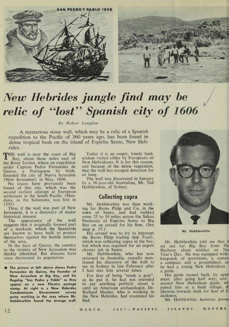
The picture at left above shows Pedro Fernandez de Quiros, the founder of New Jerusalem at Big Bay, and his flagship "San Pedroy Pablo" as they appear on a new Pitcairn postage stamp. At right is a New Hebrides Condominium Government survey party working in the area where Mr.
Hebblewhite found the strange wall.
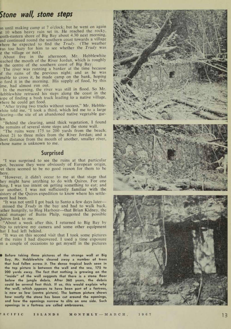
Mr. Hebblewhite
Stone wall, stone steps
)n until making camp at 7 o’clock; but he went on again it 10 when heavy rain set in. He reached the rocky, iouth-eastern shore of Big Bay about 4.30 next morning, md continued round the southern coast towards a village vhere he expected to find the Trudy. (The weather vas too hazy for him to see whether the Trudy was it the village or not). T UUI ...
About five in the afternoon. Mr. Hebblewhite cached the mouth of the River Jordan, which is roughly n the centre of the southern coast of Big Bay.
The river was running a banker at the time because >f the rains of the previous night; and as he was mable to cross it, he made camp on the bank, hoping o ford it in the morning. His supply of food, by this ime, had almost run out.
In the morning, the river was still in flood. So Mr. iebblewhite retraced his steps along the coast in the iope of finding a bush track leading to a native village, vhere he could get food.
“After trying two tracks without success,” Mr. Hebble vhite told me, “I took a third, which led me to a large bearing— the site of an abandoned native vegetable gar len.
“Behind the clearing, amid thick vegetation, I found he remains of several stone steps and the stone wall.
“The ruins were 175 to 200 yards from the beach; ibout 2i to three miles from the River Jordan; and a hort distance from the mouth of another, smaller river, vhose name is unknown to me.
Surprised
“I was surprised to see the ruins at that particular pot, because they were obviously of European origin, 'et there seemed to be no good reason for them to be here.
“However, it didn’t occur to me at that stage that hey might have anything to do with Quiros. For one hing, I was too intent on getting something to eat; and or another, I was not sufficiently familiar with the listory of the Quiros expedition to know where his settle nent had been.
“It was not until I got back to Santo a few days later— missed the Trudy in the bay and had to walk back, ather hungrily, to Hog Harbour—that Brian Kidney, the ocal manager of Burns Philp, suggested the possible Quiros link to me.
“About a week after this, I returned to Big Bay by hip to retrieve my camera and some other equipment hat I had left behind.
“It was on this second visit that I took some pictures >f the ruins I had discovered. I used a time exposure m a couple of occasions to get myself in the pictures
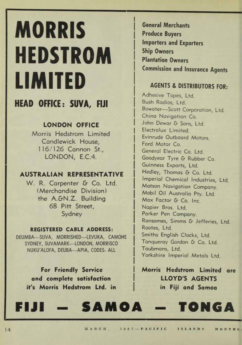
Before taking these pictures of the strange wall at Big Bay, Mr. Hebblewhite cleared away a number of trees that had fallen across it. The dense tropical bush seen in the top picture is between the wall and the sea, 175 to 200 yards away. The fact that nothing is growing on the “inside" of the wall suggests that there is a stone floor below the jungle debris. After 360 years, the debris could be several feet thick. If so, this would explain why the wall, which appears to have been part of a fortress, is now so low (centre picture). The bottom picture shows how neatly the stone has been cut around the openings, and how the openings narrow to slits on one side. Such openings in a fortress are called embrasures.
Spaniards sought southern continent
ar purposes of comparison, as I was lone at the time.”
Mr. Hebblewhite told me that store taking his shots, he had cleared way a number of trees that had dlen across the wall.
The wall was about 25 feet long, 15 iches wide and four to five feet high, ith two apertures eight or nine feet part and two feet from the top.
The wall was made of coral rocks ;mented together with mortar of >me kind, and the rocks were jnerally irregular in shape. But round the apertures, they had been lirly neatly cut and squared.
The apertures were about 15 inches piare on one side of the wall, arrowing to slits about six inches ide (by 15 inches deep) on the ther, the beach side.
Mr. Hebblewhite said that the one steps he had found were also a the beach side —about 10 yards om the wall and leading up to it juare on.
He added that a local New Hebri ean he had questioned knew nothing f the wall’s history, except that it ad been there as long as his parents auld remember.
The idea that the wall may once ave been part of a fortress had not ccurred to Mr. Hebblewhite when he )ld me his story.
But it struck me immediately he escribed the two apertures to me and lowed me his pictures of them. (The openings answer precisely to
the definition of “embrasure” in old time military parlance—i.e., “an opening in a rampart or fortified wall, with sides bevelled, so that the aperture is wider inside than out side, through which guns, etc., can be fired.”) Subsequent research in the seven known narratives of the Quiros ex pedition (all of which have been translated into English and published) revealed that the Spaniards did erect a fortress at New Jerusalem, and that the site of their city was some where in the vicinity of Mr. Hebble white’s discovery.
Started from Peru
The narratives describe how the Quiros expedition left Callao, Peru, in three ships on December 21, 1605, to try to discover an unknown con tinent that was thought to exist in the South Pacific.
The commander of the expedition, a devoutly religious man, also hoped to conquer the unknown land for the glory of God and Christendom.
Sailing westward for four months, sighting and touching at a few islands here and there, the Spaniards finally reached the Santa Cruz Islands, south of the Solomons. From there, they continued southwards, and as the double chain of islands now known as the New Hebrides came in sight, each overlapping the other as far as the eye could see, Quiros be came convinced that he had found the continent he sought.
He named the new land La Australia del Espiritu Santo (Southern Land of the Holy Ghost).
This has since been shortened to Espiritu Santo or simply Santo, and now applies only to the largest island in the New Hebrides.
On May 3, 1606, the three Spanish ships entered a large bay on the northern side of Espiritu Santo, which Quiros called Bay of St. Philip and St. James. This is the bay now known locally as Big Bay.
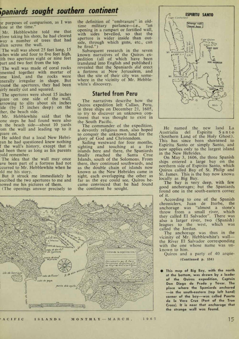
The bay is very deep, with few good anchorages; but the Spaniards found one in the south-eastern corner of it.
According to one of the Spanish chroniclers, Juan de Iturbe, the anchorage was “almost a stone’s throw from a small river, which they called El Salvador”. There was also a larger river, two (Spanish) leagues to the west, which was called the Jordan.
The anchorage was thus in the vicinity of Mr. Hebblewhite’s wall— the River El Salvador corresponding with the one whose name was un known to him.
Quiros and a party of 40 arque
(Continued p. 154)
This map of Big Bay, with the north at the bottom, was drawn by a leader of the Quiros expedition, Captain Don Diego de Prado y Tovar. The place where the Spaniards anchored —in the south-eastern (top left hand) corner of the bay—was called Puerto de la Vera Cruz (Port of the True Cross). It is near that anchorage that the strange wall was found.
busiers went ashore for the first time May 4, 1606, to find a spot to a J? r * g f° r further exploration work. There were other excursions ashore on succeeding days.
The natives, who were numerous, did not take kindly to the new comers, especially after a few arquebuses were fired and blood was let.
So the Spaniards—in the words of Fray Martin de Munilla—decided "to make a stockade on shore and to cut down trees, making a clear ing for greater security against the natives”.
Fray Martin recorded that the stockade was built on May 9, 1606, and that it was fortified with “sturdy stakes and earthworks with loop holes”.
“Everything was well made and fortified,” he said.
The only other chronicler to leave a description of the stockade was the chief pilot, Caspar Gonzalez de Leza.
He tells how 40 arquebusiers and 30 shield bearers put up a house “in the best manner they could . . . for the corps de garde.” The building had a sail for a roof, and “there was great vigilance kept [in it] on account of the great number of natives.”
Following the erection of the stockade, Quiros grandiloquently took possession of La Austrialia del Espiritu Santo, as far south as the South Pole, in the name of the Church, the Pope and the King of Spain.
End of New Jerusalem
With equally long-winded phrases, he formally founded the city of New Jerusalem and appointed all sorts of high-sounding officials to run it.
He also made every member of his expedition—Negro cooks and all —Knights of the Order of the Holv Ghost, and gave them crosses of blue taffeta to wear on their chests.
There were fireworks, religious processions, high masses and much beating of drums.
But New Jerusalem never really got going; and there is no documen tary evidence that any permanent building was erected apart from the stockade.
On May 28, 1606—after a stay of only 25 days— most of the Spaniards became violently ill through eating poisonous fish. Eleven days later they abandoned New Jerusalem and La Austrialia del Espiritu Santo for good.
Quiros ship sailed back across t Pacific to Mexico via California. TB of his second-in-command, Luis Vs de Torres, passed through what now known as Torres Strait at reached the Philippines.
Nearly 170 years passed befo the next European visitor, the ce; orated Captain Cook, sailed into B Bay and checked off such landman ot the Spaniards as he could identiii A century later, Big Bay was st; so little frequented by Europeat that Cook s account of the area coc tmued to be the main source of i formation for the South Pacific sat ing directories of the time.
The area is little better knov to white men even today.
As Professor A. J. (Jock) Marsh; wrote in his book, The Blw Musketeers, in 1937: “Few nui visit Big Bay. The crew of the a inter-islander see the great grim gu for a few hours every two month missionaries come—and always go whilst traders of scanty scrupll nowadays make rare visits. The; are spasmodic trips of inspection H the district officer, peregrinations il occasional wandering scientists. .
Doubt about relics
Referring to the Spaniards’ visn Professor Marshall said: “Quir« relics remain undiscovered. It doubtful if any ever existed and, i any case, more than three centuries o Yora (Jordan) floods, earthquake; hurricanes and torrential tropic dowi pours would scarcely permit the sui vival of any structure the Spaniaro would build during their brief stay.., Stone, though, is an extremel durable thing, and lasts much bette than some people would give credit for.
Look at the Pyramids! Look s the Coliseum in Rome!
Look at Mr. Hebblewhite’s wall If that is not a relic of the long gone Spaniards, what is it?
Footnote : Without having seen the photographs, Mr. H. E. Maude, Pra fessorial Fellow in the Department a Pacific History at the Australian National University and author of . paper on “Spanish Discoveries in th*i Central Pacific”, told me he thoughr it was highly likely that the wall anoi stone steps found by Mr. Hebblewhitn were relics of Quiros’ New Jerusalem' Many stone buildings of the native inhabitants of the Pacific, which wen still in existence, were built mucH earlier than 1606, he said.