Australia Acts Hurriedly to Avoid NG Border Trouble
pp. 19-20 · Read in the full issue
Avoid NG Border Trouble
The Australian Government has acted hurriedly in recent weeks to make sure that about 350 square miles of territory in Trustee New Guinea is not claimed by Indonesia when the Indonesians take over Netherlands New Guinea on May 1 next year.
SINCE June, the P-NG Administra tion has been rushing parties of administrative, civil aviation, public works and other departmental officials into the area to establish patrol posts, lay out air strips, survey jeep roads, and, in short, establish Australian control.
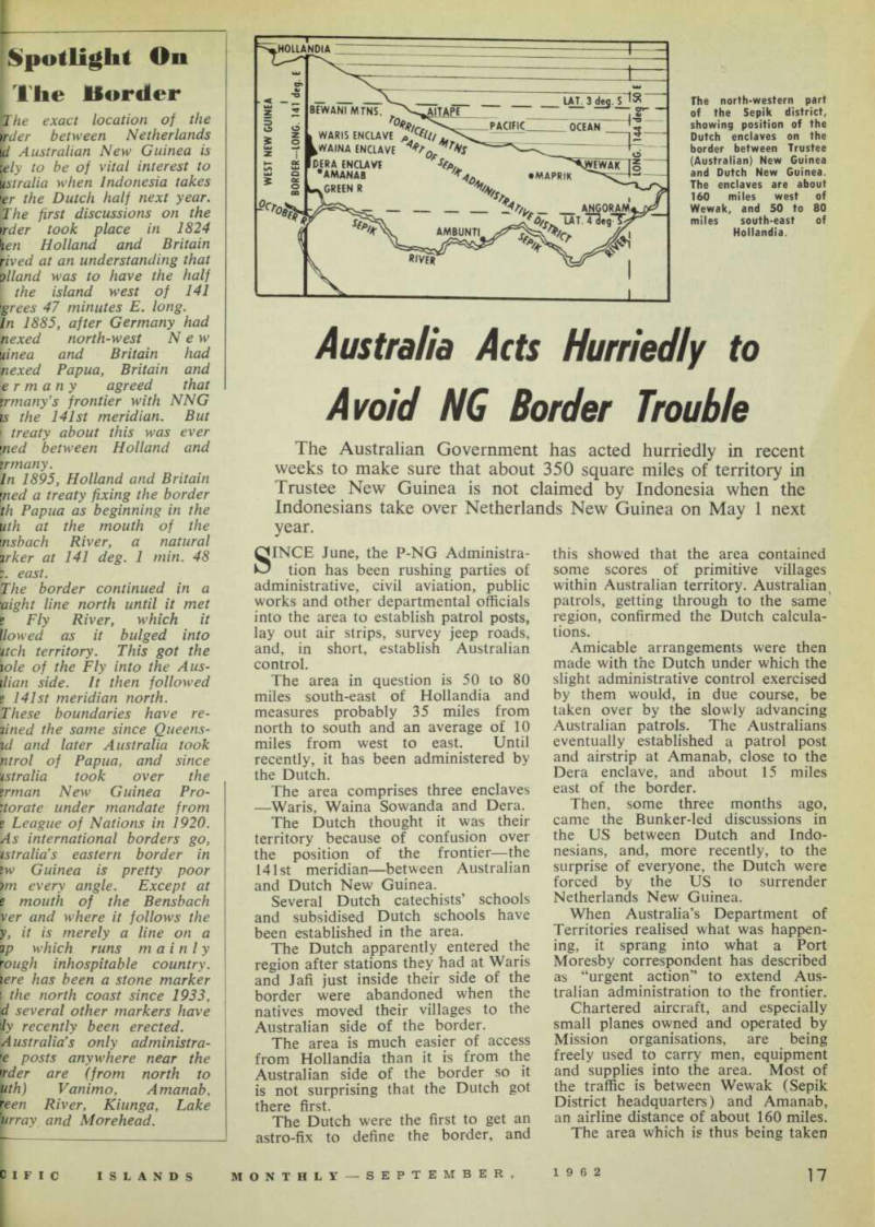
The area in question is 50 to 80 miles south-east of Hollandia and measures probably 35 miles from north to south and an average of 10 miles from west to east. Until recently, it has been administered by the Dutch.
The area comprises three enclaves —Waris, Waina Sowanda and Dera.
The Dutch thought it was their territory because of confusion over the position of the frontier —the 141st meridian—between Australian and Dutch New Guinea.
Several Dutch catechists’ schools and subsidised Dutch schools have been established in the area.
The Dutch apparently entered the region after stations they had at Waris and Jafi just inside their side of the border were abandoned when the natives moved their villages to the Australian side of the border.
The area is much easier of access from Hollandia than it is from the Australian side of the border so it is not surprising that the Dutch got there first.
The Dutch were the first to get an astro-fix to define the border, and
this showed that the area contained some scores of primitive villages within Australian territory. Australian patrols, getting through to the same region, confirmed the Dutch calcula tions.
Amicable arrangements were then made with the Dutch under which the slight administrative control exercised by them would, in due course, be taken over by the slowly advancing Australian patrols. The Australians eventually established a patrol post and airstrip at Amanab, close to the Dera enclave, and about 15 miles east of the border.
Then, some three months ago, came the Bunker-led discussions in the US between Dutch and Indo nesians, and, more recently, to the surprise of everyone, the Dutch were forced by the US to surrender Netherlands New Guinea.
When Australia’s Department of Territories realised what was happen ing, it sprang into what a Port Moresby correspondent has described as “urgent action” to extend Aus tralian administration to the frontier.
Chartered aircraft, and especially small planes owned and operated by Mission organisations, are being freely used to carry men, equipment and supplies into the area. Most of the traffic is between Wewak (Sepik District headquarters) and Amanab, an airline distance of about 160 miles.
The area which is thus being taken
oyer in a hurry lies generally between high ranges of mountains. There are said to be wide areas of fertile land, at an average height of between 1,000 and 1,500 feet, fairly thickly settled by primitive but friendly natives—people similar to those now under the control of the Dutch, west of the border.
The area lies west of the Hordern River (tributary of Sepik), south-west of Aitape sub-district, and west of Lumi sub-distict.
A message from The Hague in June that “two villages”, Waris and Jafi, previously thought to be in NNG, had been found on a re suryey of the boundary to be in Aus tralian Trust Territory reportedly brought angry howls from Indonesian newspapers at that time. The news papers are said to have protested against 3,000 “souls” being handed over by the Dutch to the Australians without consulting the villagers themselves. (PIM, July, p. 165).
No mention was made about the urgent action over the three Dutch enclaves in a Press bulletin about a survey of the Australian-Dutch border issued on August 15 by the Department of Information in Port Moresby.
This merely said that a survey of the border, begun in July, was almost finished.
“Both Australian and Dutch surveyors are now marking the boundary line,” the bulletin said.
“A senior officer in the Lands Department, Mr. Sparkes-Carroll, said today that the surveyors will put up tw'o cement boundary markers.
“These will be at Domongi (where the border meets the Fly River) in the south and Anguramat (where it meets in the north).
“Mr. Sparkes-Carroll said the Dutch surveyors came to Port Moresby in June to meet Australian surveyor, Mr. O. Dent. The men went to the Western District and left Daru (mouth of Fly River) by boat on July 14. They inspected the cement marker at the mouth of the Bensbach River and went on up the Fly River to put up two more markers.
“The Dutch surveyors are checking the position of boundary markers placed by Australian surveyors two years ago.
“The surveyors will arrive back in Port Moresby this month to talk about photographing the rest of the border.”