To “Melanesian” Disaster
pp. 71-73 · Read in the full issue

Another Marine Mystery
Wide Air-Sea Search Found Eew Clues
For details of the ship and facts surrounding her disappear ance sde Shipping Section , page 101, this issue.
It is unlikely that the reason for the disaster to the Solo mon Islands Govt.’s 240 gross tons Melanesian will ever be satisfactorily established. In its way, this is as great a mystery of the sea as the disappearance of Joyita in 1955—but because the world was busy with a Middle East crisis, the fate of Melanesian has not been the subject of such wild newspaper
speculation.
FOR a week after the vessel was missed—on July 12—the biggest sea and air search undertaken for a small ship in the South Pacific was under way. All that was found was some minor wreckage and the body of one Melanesian, about 30 miles west of where the vessel last reported by radio, on July 10, at 9 a.m.
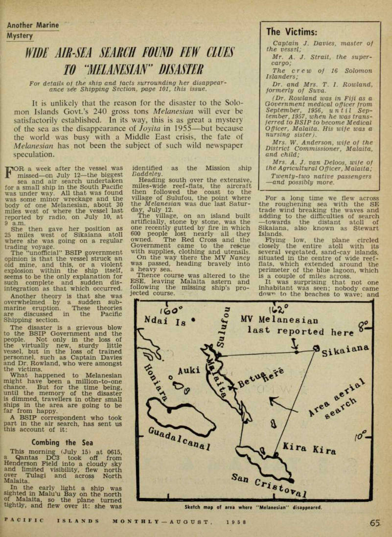
She then gave her position as 25 miles west of Sikaiana atoll where she was going on a regular trading voyage.
The “unofficial” BSIP government opinion is that the vessel struck an oid mine, and this, or a violent explosion within the ship itself, seems to be the only explanation for such complete and sudden dis integration as that which occurred.
Another theory is that she was overwhelmed by a sudden sub marine eruption. These theories are discussed in the Pacific Shipping section.
The disaster is a grievous blow to the BSIP Government and the people. Not only in the loss of the virtually new, sturdy little vessel, but in the loss of trained personnel, such as Captain Davies and Dr. Rowland, who were amongst the victims.
What happened to Melanesian might have been a million-to-one chance. But for the time being, until the memory of the disaster is dimmed, travellers in other small ships in the area are going to be far from happy.
A BSIP correspondent who took part in the air search, has sent us this account of it:
Combing the Sea
This morning (July 15) at 0615, a Qantas DC3 took off from Henderson Field into a cloudy sky and limited visibility, flew north over Tulagi and across North Malaita.
In the early light a ship was sighted in Malu’u Bay on the north of Malaita, so the plane turned tightly, and flew over it: she was
identified as the Mission ship Daddeley.
Heading south over the extensive, miles-wide reef-flats, the aircraft then followed the coast to the village of Sulufou, the point where the Melanesian was due last Satur day, July 12.
The village, on an island built artificially, stone by stone, was the one recently gutted by fire in which 600 people lost nearly all they owned. The Red Cross and the Government came to the rescue with supplies, clothing and utensils.
On the way there the MV Nancy was passed, heading bravely into a heavy sea.
Thence course was altered to the ESE, leaving Malaita astern and following the missing ship’s pro jected course.
For a long time we flew across the roughening sea with the SE trade wind breaking the waves and adding to the difficulties of search —towards the distant atoll of Sikaiana, also known as Stewart Islands.
Flying low, the nlane circled closely the entire atoll with its several vegetated, sand-cay islands. situated in the centre of wide reef flats, which extended around the perimeter of the blue lagoon, which is a couple of miles across.
It was surprising that not one inhabitant was seen; nobody came down to the beaches to wave: and
Sketch map of area where "Melanesian" disappeared.
these are friendly people.
Perhaps they had merpories of unhappier war days when un friendly planes flew low; or perhaps they were all working in their gardens. There was no sign what ever of the Melanesian.
Never Reached Sikaiana She had probably been here on Thursday we thought, as she re ported herself 25 miles west, heading this way (but we were subsequently found to be wrong, as Melanesian had never been there at all). An attempt was made to raise her by radio at 0900 hours Friday 11th, so as to warn the Sikaiana people of the approach of the seismic sea wave from Alaska sometime that morning. We received no reply then, but considered that the radio might have suffered a temporary breakdown.
Flying back along her proposed route to Sulufou, a very wide area was covered by making square zig-zags with search lines two visibility distances apart.
A igreat triangle, Sikaiana-Malaita, was thus covered systematically.
Once we doubled smartly back as it was thought a small dinghy had been seen: but it transpired just to be another “seahorse” —a pro longed broken wave driven by the strong trade wind.
Another time we stood on our wing tip to identify a ship which was sighted, headed towards Sikaiana.
It was the MV Margery, with four lookouts posted at the quarters, and District Commissioner St. G.
Anderson, waving as we swooped low alongside, close enough to see the faces of the crew. (Mr. Ander son’s wife and child were lost on
Melanesian).
She was making good way in the rough beam sea with the object of ascertaining whether Melanesian had been at Sikaiana. . Clouds hung low, reducing the visibility as we travelled further west, and ultimately we reached again the north end of Malaita m the rain.
This time we turned south east again, flying low, and following closely the coastal cliffs and fringing reefs looking for signs of men, dinghies or wreckage—but nothing was seen at all.
Occasionally we banked steeply to run out and circle outlying islands as we passed them. Nothing was missed.
Betua on Reef This coast is fortunate with its great harbours, inside any one of which we hoped that MV Mela ncsian might be anchoring.
We flew close past Sinarangu Harbour, the scene of the murder ?n ini, Llll , and their P oli ce patrol S. lf 1927 - We had been flying for an r> hOUr 0r S0 ’ When two small Government ships were observed ahead of us—one standing
off in deep water, and the other unhappily ashore on the wide brown exposed coral-flat of the fringing reef, with the waves running up the radially-eroded channels on the sea-edge.
We identified her as the MV Betua lying on her side almost com pletely dry, as it was low tide, and surrounded by islanders and canoes.
This was a second shock to the system, having two ships of our small fleet out of action. We circled low twice and photographed the situation before continuing south on our shoreline search for the Melanesian beneath the limestone cliffs above which the dense green jungle extended to the mountain tops, with here and there a neat village of leaf houses on the ridges, or along the shores.
Rivers and bays indented the coast line. Soon we reached Maramasike Passage with its many flat vegetated islets—where Mala is divided from Mala Ita—or, as we usually say, “Big Malaita” from “Small Malaita”.
A well laid-out Mission station, and orderly rows of village houses on clearings back from the sandy beaches were passed. We rounded the tip of South Malaita. To the westward along the other coast which was now in view, was Maka, the Police Post near the entrance to the Maramasike Passage.
It was Maka that reported on Saturday afternoon that it had heard a powerful explosion to the eastward, which had not been ex plained.
Was this explosion due to a tectonic earthquake? Was it an old mine washing ashore? Was it an exploding bomb? Had some one been using gelignite illegally?
Certainly nobody could connect it with the Melanesian, which should have been scores of miles to the north-westward, headed for Sulufou And so across the Sealark Channel we headed for Guadal canal’s great ten-mile plains; with its extensive grass patches at the
foot of the dark mountains behind —up to 8,000 feet high and masked by the clouds.
Home, Without a Clue
First Rua Sura Island —then R«re Point.—the Berande Plantation — over the great wide, dirty green and muddy rivers meandering their way to the sea—until at last, flying low over the old grass-grown war time fields of Carney and Koli, we landed again at Henderson Airfield.
Fresh observers took off at 1315 from Henderson Field, skirted South Malaita to Ulawa Island to the eastward, and proceeded to search the large triangular area system atically—towards Sikaiana.
MV Margery still battling the heavy seas, was seen again, very nearly there. As she asked for a line of the islands, the aircraft circled again around Sikaiana Atoll, and this time was greeted by hundreds of people waving on the beaches.
The Margery reached there before nightfall.
Three ships which had been standing by left with all the avail able engineers and mechanics from the Marine Department Base at Tulagi—bound for the area of the search. The entire Protectorate fleet is now engaged.