Thing’ in the Big Bay bush
pp. 71-77 · Read in the full issue


The untold story of The Thing’ in the Big Bay bush
Stone Fort,
Trade
Store Or
Pigsty?
Robert Langdon takes a new look at an old controversy
Two things in recent weeks have set me thinking again about a story I have been meaning to write for PIM for the past eleven years. It is a story about a structure in the bush at Big Bay, Espiritu Santo, New Hebrides, that came to be known as ‘Lang don’s Wall’. Judy Tudor de scribed it in print on one occasion as ‘The Thing’.
The first thing that called ‘The Thing’ to mind again was a reference to it in Judy Tudor’s breezy review of the Pacific’s ‘politically-frantic sixties’ (PIM, June, p 69).
Then I was reminded of it again by the frequent appear ance in the news of the New Hebrides secessionist leader Jimmy Stephens. Actually, it was Stephens who sidetracked me from telling my story back in 1969 when it was red hot.
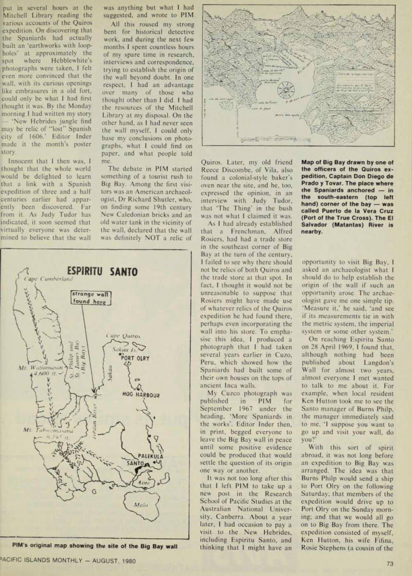
As Judy Tudor recalled in her article in June, Langdon’s Wall or The Thing is ‘an old over-grown stone wall’ that one Ted Hebblewhite chanced to discover at Big Bay in January 1967. Its discovery started a controversy that raged in the pages of PIM for many months.
The controversy began when I then a member of PlM’s editorial staff wrote an article suggesting that the wall was a relic of the Spanish explorer Pedro Fernandez de Quiros, who had tried to estab lish a settlement at Big Bay in 1606.
The article, as Judy Tudor put it in June, caused a number of ‘vociferous readers’ to come to light with ‘a dozen reasons’ why my suggestion was wrong, claiming that the wall was the remains of a ‘l9th century trade store, mission station, pig-pen, or what-have-you.’
However, despite the lively debate, the question of who actually built the wall never, in Judy’s opinion, got any closer to solution.
As Judy is a self-confessed cynic, I doubt whether it is in her nature to believe that the question of the origin of the Big Bay wall can ever be solved. But for those who are more open to persuasion, I think it’s about lime that I told how, in my view, that problem was, in fact, solved.
To put my story in perspec tive, it is necessary to go back to a Friday afternoon in late
February 1967. The scene was PI M’s old office, then in Alberta Street, Sydney. Editor Stuart Inder and I had almost finished putting the March issue of PIM to bed when into the office came the Ted Hebblewhite referred to above.
We had met Hebblewhite two or three times before and knew that he was a descendant of the two Hebblewhite brothers who had settled on Efate, New Hebrides, in the 1870 s. We knew also that his family still claimed to own land in those parts, and that Ted had recently spent several months in the New Hebrides travelling around and working for Burns Philp.
Hebblewhile’s mission on this occasion was to ask if we might be interested in publishing some colour slides and other photographs that he had taken of New Hebridean scenes. I undertook to look through his collection, and did so without too much enthusi asm until I came to a couple of pictures that depicted a wall with two unusual openings in it. ‘Where did you take these?’
I asked.
‘Up on Santo,’ Hebblewhite said. ‘But what part of Santo?’ ‘ln Big Bay at a place near the southeastern corner, a couple of miles before you get to the River Jordan. ‘Then that’s a relic of the Quiros expedition of 1606,’ I said instantly.
I explained that I had lived in South America and Spain for several years; that I was reasonably familiar with Spanish architecture; and that the wall in his photographs looked like a Spanish wall to me. I then took down a copy of the current Pacific Islands Year Book, turned to the sec tion on the New Hebrides and read out the following passage: ‘The first European to see the New Hebrides was the Spanish explorer Quiros, who sighted several islands in the Banks Group and Maewo (Aur ora) on April 25, 1606. Six days later, he anchored in a large bay at an island which he called Austrialia del Espiritu Santo. To the large bay, he gave the name of St. Philip and St. James, and on the shores of a river flowing into that bay he established the settlement of La Nueva Jerusalem. This island is today known as Santo.
Owing to sickness, and dissen sions with the natives, the settlement was soon aban doned, and today, so far as is known, no traces of it exist.’
Having ascertained from Hebblewhite that the wall in his photographs was, indeed, near the shores of a river flowing into Big Bay, and having questioned him on how he had come to discover the wall, I announced to Stuart Inder that I thought I had the makings of a good story to help fill the last few pages of our March issue.
Over the ensuing weekend, 1
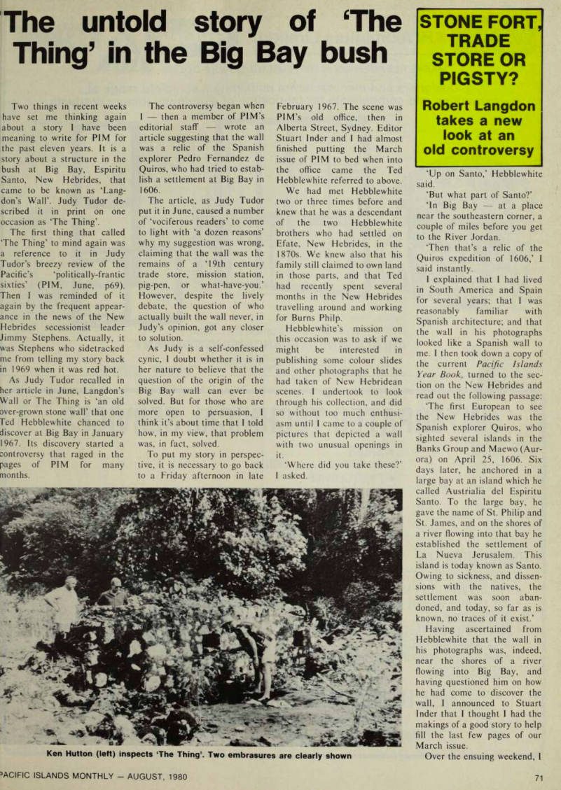
Ken Hutton (left) inspects ‘The Thing’. Two embrasures are clearly shown
put in several hours at the Mitchell Library reading the various accounts of the Quiros expedition. On discovering that the Spaniards had actually built an ‘earthworks with loop holes’ at approximately the spot where Hebblewhite’s photographs were taken, I felt even more convinced that the wall, with its curious openings like embrasures in a old fort, could only be what I had first thought it was. By the Monday morning I had written my story ‘New Hebrides jungle find may be relic of “lost” Spanish city of 1606.’ Editor Inder made it the month’s poster story.
Innocent that I then was, I thought that the whole world would be delighted to learn that a link with a Spanish expedition of three and a half centuries earlier had appar ently been discovered. Far from it. As Judy Tudor has indicated, it soon seemed that virtually everyone was deter mined to believe that the wall
was anything but what I had suggested, and wrote to PIM All this roused my strong bent for historical detective work, and during the next few months I spent countless hours of my spare time in research, interviews and correspondence, trying to establish the origin of the wall beyond doubt. In one respect, I had an advantage over many of those who thought other than 1 did. 1 had the resources of the Mitchell Library at my disposal. On the other hand, as I had never seen the wall myself, I could only base my conclusions on photo graphs, what I could find on paper, and what people told me.
The debate in PIM started something of a tourist rush to Big Bay. Among the first visi tors was an American archaeol ogist, Dr Richard Shutler, who, on finding some 19th century New Caledonian bricks and an old water tank in the vicinity of the wall, declared that the wall was definitely NOT a relic of
Quiros. Later, my old friend Reece Discombe, of Vila, also found a colonial-style baker’s oven near the site, and he, too, expressed the opinion, in an interview with Judy Tudor, that The Thing’ in the bush was not what I claimed it was.
As I had already established that a Frenchman, Alfred Rosiers, had had a trade store in the southeast corner of Big Bay at the turn of the century, I failed to see why there should not be relics of both Quiros and the trade store at that spot. In fact, I thought it would not be unreasonable to suppose that Rosiers might have made use of whatever relics of the Quiros expedition he had found there, perhaps even incorporating the wall into his store. To empha sise this idea, I produced a photograph that I had taken several years earlier in Cuzo, Peru, which showed how the Spaniards had built some of their own houses on the tops of ancient Inca walls.
My Cuzco photograph was published in PIM for September 1967 under the heading, ‘More Spaniards in the works’. Editor Inder then, in print, begged everyone to leave the Big Bay wall in peace until some positive evidence could be produced that would settle the question of its origin one way or another.
It was not too long after this that I left PIM to take up a new post in the Research School of Pacific Studies at the Australian National Univer sity, Canberra. About a year later, I had occasion to pay a visit to the New Hebrides, including Espiritu Santo, and thinking that 1 might have an
opportunity to visit Big Bay, I asked an archaeologist what I should do to help establish the origin of the wall if such an opportunity arose. The archae ologist gave me one simple tip. ‘Measure it,’ he said, ‘and see if its measurements tie in with the metric system, the imperial system or some other system.’
On reaching Espiritu Santo on 28 April 1969, I found that, although nothing had been published about Langdon’s Wall for almost two years, almost everyone I met wanted to talk to me about it. For example, when local resident Ken Hutton took me to see the Santo manager of Burns Philp, the manager immediately said to me, ‘I suppose you want to go up and visit your wall, do you?’
With this sort of spirit abroad, it was not long before an expedition to Big Bay was arranged. The idea was that Burns Philp would send a ship to Port Olry on the following Saturday; that members of the expedition would drive up to Port Olry on the Sunday morn ing; and that we would all go on to Big Bay from there. The expedition consisted of myself, Ken Hutton, his wife Fifina, Rosie Stephens (a cousin of the
PIM's original map showing the site of the Big Bay wall
Map of Big Bay drawn by one of the officers of the Quiros ex pedition, Captain Don Diego de Prado y Tovar. The place where (he Spaniards anchored in the south-eastern (top left hand) corner of the bay was called Puerto de la Vera Cruz (Port of the True Cross). The El Salvador (Matantas) River is nearby.
• celebrated Jimmy Stephens), ;and three members of the Burns Philp staff.
The road as far as Turtle Bay was built during the war by the Americans and was still in good condition. Much of it was through primeval forest with thick grasses ready to eat into the road if it should ever fall into disuse. Occasionally we saw signs erected by mem bers of the Nagriamel move ment of Jimmy Stephens ‘Private Property Keep Off.’
We reached Port Olry about 6.30 and found Burns Philp’s Neptune at anchor about a mile off shore. After some trouble we got aboard, and apart from the fact that the Neptune lost one of her two propellers when she struck a coral head (which delayed our departure until 9 o’clock), everything went according to plan.
It was an ideal day for sailing. As we came in sight of Cape Quiros at the eastern head of Big Bay, I could see a number of outcrops of coral rock high up in the jungle. It was outcrops such as these that Quiros, in 1606, imagined to be deposits of the finest marble, and it was with them that he had visions of building a huge cathedral at his settlement in Big Bay. There are no such deposits along the coast within Big Bay proper at least not as far as I could see. So Quiros’ men would have had a long haul with their ‘marble’ if the cathedral plan had got underway.
An interesting aspect of our cruise into Big Bay itself was the discovery that a map drawn by one of Quiros’ officers, Prado y Tovar, was by no means as fanciful as it seems to be away from the site. On the contrary, we found it a remark able combination of ground plan and side elevation, so that as we sailed up the bay it was easy to pick out the mountains that Prado had depicted.
It was evident, too, from the various anchorages and rivers shown on the map that the Spaniards had made a close inspection of the coast, for none of those features could be seen from shipboard, even within a few yards of the shore.
As for the small river near the spot where the main body
of Spaniards had gone ashore, this could not be seen until we were virtually on the beach.
The Spaniards called this river El Salvador. Its native name is Matantas.
We went ashore, and found that the Matantas was about 30 feet wide. It was bounded on one side by a sheer sandy bank about six feet high and on the other by thick jungle.
Having waded across it up to our knees and deposited our belongings on the jungle side, we set off at once in search of ‘my’ wall. I felt I knew exactly where to find it, and so it proved. Although it is imposs ible to see it until you are within about 10 yards of it, I walked pretty well straight to it.
The wall is about 100 yards from the sea and about 200 yards from the Matantas at the nearest point. It was rather smaller than I had expected.
But there was nothing either at first sight or after two or three hours of investigation that caused me to think that it was anything other than what 1 had originally suggested, namely, part of a small fortification that the Spaniards built to protect themselves while build ing a boat to explore the vicinity.
However, there was no doubt that another European building also stood on this site at one lime. Besides the New Caledonian bricks and water
tank already mentioned, we found a flat piece of steel, some trochus shell, a lurn-of-the century bottle, and some masonry about 20 feel from the wall containing some extremely hard cement.
A close examination of the wall itself revealed that it had originally had three em brasures not two, as I had previously been led to believe.
Only a small part of the easternmost embrasure still
A member of the expedition points to the spot where there was once a third embrasure
(remained, as about four feet of fthe wall had apparently been [broken off by falling trees.
An interesting point about the middle embrasure was that it was wider on both sides than the other, intact embrasure.
Thus, if it had been the centre piece in a fortified rampart, the central gun could have covered a wider field to left and right than those to either side of it.
As it stood, the wall was about 23 feet 4 inches long.
However, the base of a return wall that had apparently run back from it at one time showed that it was once about 27 feet long.
Having studied the wall and searched in its vicinity for half an hour or so, we decided to knock off and have lunch on the bank of the Matantas. A few minutes after we had made ourselves comfortable, Rosie Stephens suddenly said: ‘Uh uh, here come the Indians.’
We then noticed five New Hebrideans walking along the opposite bank, each carrying a long bush knife. The five men looked none too friendly, es pecially when they dropped down the bank a few yards beyond us, waded across the river, and came back towards us.
When they were within a few feet of us, two of the men stuck their knives in the sand and came forward a few more paces. The other three stood behind them, bush knives at the ready. One of the two men in front a young man of about 24, wearing shorts and a singlet twined around his neck - announced in Pidgin that the land we were sitting on was ‘land bilong Nagriamel’ and that we had no right to be there. A lot of other things were said which I could not understand, but the hostile tone was clear.
Ken Hutton who speaks ?ood Pidgin acted as our spokesman. He explained that man bilong Sydney’ (meaning ne) had merely come to Big Bay to see ‘wall bilong Quiros’; that the Neptune had deposited js where we were; and that ifter we had seen the wall the Neptune would pick us up and :arry us away again.
With much more palaver to -his effect, plus the gift of an irange apiece from Fifina Hutton, the islanders gradually
became more friendly, and finally invited us to visit their meeting house which we had noticed about 200 yards up the river. The two leaders then picked up their knives and marched off with the others along the beach towards the River Jordan.
After lunch we took up the invitation to visit the meeting house. It was a big brown leaf building with a sign over the doorway that said politely: Nagriamel Private Property Please Keep Out Sign[ed] The Chiefs and Members Thank You Nearby was a tree on which was another sign: ‘The new union of Council Chiefs; Na- Griamel of Espiritual Santo; 10/8/67. This is the truth from Na-Mile. The Griamel was vitud [visited?] today by the Chief of Espiritual Santo and the Chief of Islands.’
Ken Hutton muttered some thing about Nagriamel (or Na- Griamel) being everywhere, and went on to tell me more about its leader, Jimmy Stephens, whose name I had first heard on arriving in Santo several days earlier. Ken had, in fact, already suggested that I should write an article about Stephens; and now, having come face to face with some of his followers in the Big Bay
bush, I made up my mind that I would.
The result was that after we returned to Santo from our Big Bay expedition, I made more inquiries and later wrote the first article ever to be published on Stephens and Nagriamel. This article was entitled ‘Chief President Moses: Man with a message for 10 000 Hebrideans,’ and it appeared in PIM for July 1969.
In the same month that my article appeared, I travelled to the United States to attend a conference in Salt Lake City.
Later, I went to Tahiti where 1 gathered some important information that led, six years later, to the publication of my book The Lost Caravel. (Pacific Publications). Through all this, the idea of telling the world about the expedition I had made to Big Bay and what I had found there slipped further and further from the forefront of my mind. But it was never completely forgotten, and now that I have finally got around to it, the point of my story is: ‘The Thing’ in the bush at Big Bay was found to be 23 feet 4 inches long, as I have already said. But the base of a wall that once ran back from it shows that it was originally something like 27 feet long.
Twenty seven feet, converted to metric measure, works out at 8.235 metres. This for anyone
using the metric system is such a meaningless figure that it now seems safe to say that the Frenchman Alfred Rosiers, who ran the trade store at Big Bay at the turn of the century, is unlikely to have built a wall of such length. Nor does the unconverted figure of 27 feet give or take an inch or two seem the sort of figure that some anonymous Englishman might have picked on as the appropriate length for a wall.
On the other hand, 27 feet (or 324 inches) does seem just about the right length for a party of 17th century Span iards, for their unit of measure ment was the vara, equivalent to 32.875 imperial inches. In other words. The Thing’ in the bush at Big Bay, which was partly obscured by fallen trees when Ted Hebblewhite first saw it, seems as if it was originally intended to be 328.75 inches long or ten Spanish varas, which is a per fect Iberian figure.
Footnote: Late last year, the ‘wall bilong Quiros’ was visited by a countryman of the people who apparently built it the Spanish Ambassador to Aust ralia and New Zealand, Don Carlos M. Fernandez Shaw.
He reports that soil carried down by rain or river has built up by the wall, making it even lower, apparently, than when I saw it.
Big Bay itself, near where Spanish explorers landed three and a half centuries ago