New Guinea's Ports May Soon
pp. 31-34 · Read in the full issue
Burst At The Seams
From a Port Moresby Correspondent
Although the “Baruni Plan” is nothing more than just another plan at the moment, there is every chance that one day it will blossom forth as an exciting development.
BARUNI is not a person, but a place—or at least a name on a map. You’ll find it, if you look carefully enough, on the charts of Port Moresby harbour, and you can reach it by driving along the dirt road that skirts the harbour past Hanuabada and eventually ends at Napa Napa.
Baruni is the proposed site of a big new port development scheme aimed eventually at giving Port Moresby a new and more efficient harbour and docks area.
The spinners of this dream hope that wharves can be built over the reefs off Baruni and that the eroded hills and flat stretches immediately behind will be the site of wharf installations and a new and expanding industrial area.
The area would be served by roads leading directly inland, so that raw materials and labour could get in and out without having to follow the present torturous route through the main town area and swarming Koki.
Port Moresby’s present docks area is outstripping itself. The main wharf (now 700 ft) needs lengthening so that two ships can berth, and
storage already is inadequate. Re cently a scheme for a flour mill on the docks area met with strong local opposition, mainly on the ground that there was insufficient space, and the scheme was withdrawn.
The Baruni plan was taken a step further a few weeks ago with the completion of a hydrographic survey of the area. The results are now awaited.
Wartime Causeway
There should be fairly good sea approaches to Baruni. During World War II the harbour was frequently filled with ships and the Americans built a dock on Tatana Island and used it to good effect. The dock is not now in use—native housing is built on it—but the island itself is still connected with the mainland by a wartime causeway. The island is in the area of the proposed plan and thus could have a new lease of life.
The old Burns Philp ship Macdhui, bombed during the war, is another landmark in this general area —her rusting bones may be seen pro truding from the sea right on the edge of the reef.
Further round, almost in Port
Moresby and well out of range of the Baruni scheme, work is expected to begin soon on a brand new Army small ships operation which will add to the congestion of the existing harbour. The Army is taking over the flying-boat marine base and will turn it into headquarters for a fleet of small ships to be used on defence work up and down the New Guinea coasts.
Flying boats still land in this part of the harbour, but activity at the base does not compare with the activity of 10 years ago when Qantas operated a regular Sandringham flying boat service between Australia and New Guinea.
Despite the pressures behind the Baruni plan, the harbour problems of Port Moresby are no worse—and in fact are much better—than in most of the other nine overseas ports in the Territory.
The Territory’s major overseas ports are at, Moresby, Samarai, Lae, Kavieng, Madang, Rabaul and Daru.
Other ports are at Wewak, Lorengau and Kieta. Rabaul, Lae and Madang are the most congested—Rabaul worst of all—and according to the World Bank mission report last
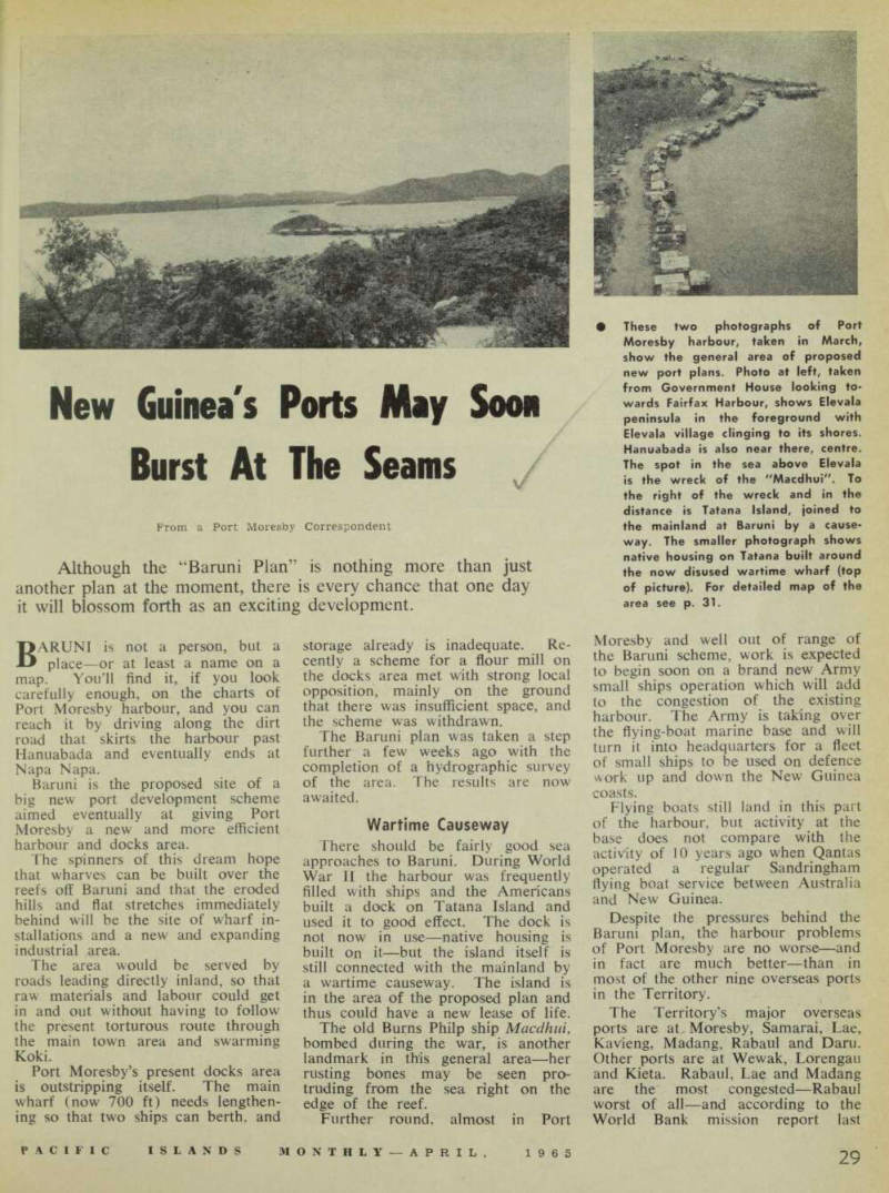
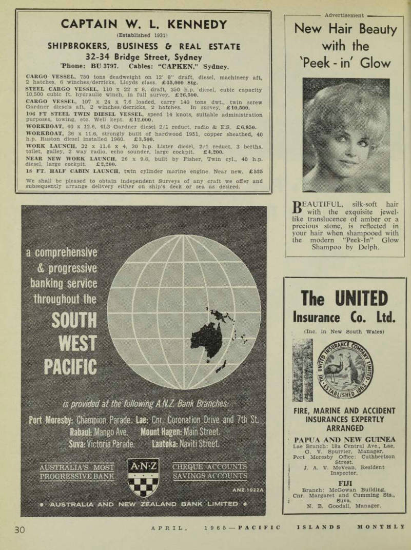
These two photographs of Port Moresby harbour, taken in March, show the general area of proposed new port plans. Photo at left, taken from Government House looking to wards Fairfax Harbour, shows Elevala peninsula in the foreground with Elevala village clinging to its shores.
Hanuabada is also near there, centre.
The spot in the sea above Elevala is the wreck of the "Macdhui". To the right of the wreck and in the distance is Tatana Island, joined to the mainland at Baruni by a cause way. The smaller photograph shows native housing on Tatana built around the now disused wartime wharf (top of picture). For detailed map of the area see p. 31.
year, Port Moresby, Samarai and Kavieng overseas port facilities are the only ones adequate to handle present traffic.
Territory ports have just growed.
The Territory after the war found itself with no installations of any importance anywhere and the erection of them in the next few years was a stopgap affair designed to take the pressure off particular areas but with no real planning for the future.
None of the wharves was
adequate. Rabaul still makes do with a wharf built by filling a sunken ship with concrete. Port access every where is generally poor, thus bring ing about congestion and inefficiency.
Yet wharves and efficient harbours are vital to the Territory, for they handle the exports and imports, on which the country depends, Rabaul is the principal port of export, handling the copra and cocoa of New Britain and most of that produced in New Ireland and
Bougainville. Madang serves the north coast and is the main port for the Highlands. Most of the Terri tory’s processed forest products pass through Lae. Rubber and copra from Papua are shipped through Port Moresby and Samarai.
More than 90 per cent, of the imports pass through the four major ports of Moresby, Rabaul, Madang and Lae, with Moresby handling more than a third of the import total.
In addition, coastal shipping transports almost half of all the exports to the overseas ports —the rest goes by road.
Air transport is important to the Territory’s export trade only because of the coffee movements from the Highlands via Madang, but this is comparatively small. The main role of air transport in the Territory is to move passengers and passenger traffic by ships is comparatively small.
Deficient Facilities The World Bank mission’s report pin-pointed port facilities and coastal shipping services as the major trans port deficiencies in the Territory, out weighing either road or air deficien cies.
It considered that top priorities in the development of all transport facilities over the next five years should be expansion of major ports and the modernisation and re organisation of coastal shipping.
The mission pointed out that the main factors influencing shipping rates are operating costs, imbalance
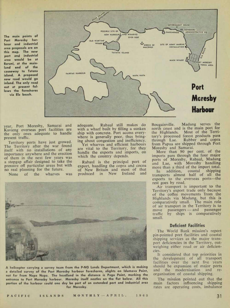
The main points of Port Moresby har bour and industrial area proposals are on this map. The new port and industrial area would be at Baruni, at the main land end of the causeway to Tatana island. A proposed new road would go inland. The only road out at present fol lows the foreshores via Ela beach.
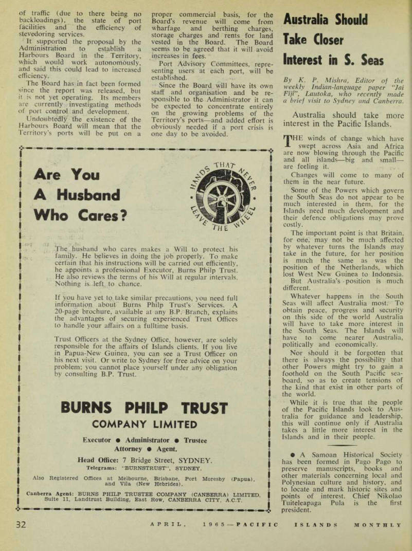
A helicopter carrying a survey team from the P-NG Lands Department, which is making a detailed survey of the Port Moresby harbour foreshores, alights on Idumava Point, not far from Napa Napa. The headland in the distance is Paga Point, marking the entrance to Port Moresby harbour. Moresby itself nestles on the flat below. All this portion of the harbour could one day be part of an extended port and industrial area for Moresby.
Port Moresby Harbour
of traffic (due to there being no backloadings), the state of port facilities and the efficiency of stevedoring services.
It supported the proposal by the Administration to establish a Harbours Board in the Territory, which would work autonomously, and said this could lead to increased efficiency.
The Board has in fact been formed since the report was released, but it is not yet operating. Its members are currently investigating methods of port control and development.
Undoubtedly the existence of the Harbours Board will mean that the Territory’s ports will be put on a
proper commercial basis, for the Board’s revenue will come from wharfage and berthing charges, storage charges and rents for land vested in the Board. The Board seems to be agreed that it will avoid increases in fees.
Port Advisory Committees, repre senting users at each port, will be established.
Since the Board will have its own staff and organisation and be re sponsible to the Administrator it can be expected to concentrate entirely on the growing problems of the Territory’s ports—and added effort is obviously needed if a port crisis is one day to be avoided.