Just Accidents
pp. 73-81 · Read in the full issue
Polynesian Voyages Were Just Accidents
• The ocean voyages of the ancient Polynesians have a sacred mysticism for some people but not for the author of this article who shoots-down their theories as incurable romanticism. He ridicules the idea that the Polynesians had some sort of nautical sixth sense; and believes that their voyages were one-way affairs of pure accident. He presents the practical navigator's point of view, based on his 30 years of sailing the Pacific, and cuts right across the prettier theories of other experts who have attributed almost supernatural skills to the old Polynesians.
By Captain Brett Hilder
Polynesian migration to almost every remote sland in the wide Pacific cannot be doubted; nor ;an the belief that the furthest corners of the liangle, Hawaii, New Zealand and Easter Island, vere settled by Eastern Polynesians. What is in loubt is whether these long distance voyages were jlanned or accidental.
A RECENT book by Andrew Sharp, of New Zealand, proves convincingly that all voyages over 300 miles were accidental drifts, feither in canoes blown out to sea and unable to regain their home, or fcanoe-loads of exiles or refugees fleeing from their victorious enemies. [ Sharp did not invent this theory, but he restates Captain Cook’s own opinion in a very well documented way. (His book, Ancient Voyagers in the Pacific is available in the paperback Penguin series), t Sharp debunks all the fanciful and mythical systems of navigation at tributed to the Polynesians by their legends and their European admirers.
The latter were mostly anthro pologists, and not navigators, but unfortunately, one of the authors who dreamed up the most far-fetched ‘systems of navigation for the Poly nesians was himself a famous navigator. He was the late Harold Catty, to whom we are specially for his brilliant Raft Book, and his final Nature is Your Guide.
I Catty proved himself both as a navigator by sea and air,
and as a keen researcher in the history of navigation, and in these respects a worthy successor to Cook himself. But I cannot believe that he could have been quite honest in his propaganda in aid of the misty reaches of Polynesian navigation.
The only thine he denied them was a mystical sixth sense of direction.
Their uncanny skill, in fact, came from long years of keen observation, study and practice, but with writers who were not navigators, a sixth sense has been invoked to make up for the lack of navigational mstru ments and techniques.
One of the latest of these writers, Robert C. Suggs, is perhaps the worst in this regard. His work. The Island Civilisations of a Mentor paperback of the New American Library, is full and comprehensive, and includes the latest archaeological findings and carbon-dates to the time of pubhca tion. It is the best book on that subject since Sir Peter Buck’s Vikings of the Sunrise, but it contains the most contentious and even ridiculous arguments in different sections.
Polynesians Were Melanesians He states that both the Polynesians and their language developed from the Melanesians, who had come from the South Coast of China, and were settled in their present islands about 1,000 BC. I have always thought that the two races were as different as Africa and China could make them, and I feel sure that Melanesia was settled 10 times as long ago.
But when Suggs comes to his Chapter Seven, dealing with methods of navigation, he really goes into orbit, and I cannot resist the tempta tion to quote him. In this chapter, which he has the decency to call “Sails and Stars”, he writes: “The magnitude of distances covered in settling the islands of New Zealand, Hawaii and Easter Island, represent genuine feats of navigation of the highest rank”. (Over)
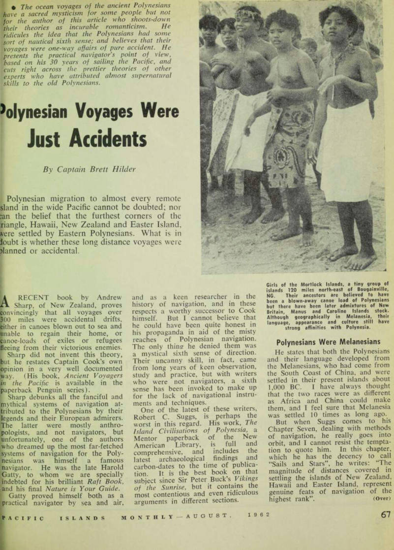
Girls of the Mortlock Islands, a tiny group of islands 120 miles north-east of Bougainville, NG. Their ancestors are believed to have been a blown-away canoe load of Polynesians but there have been later admixtures of New Britain, Manus and Caroline Islands stock.
Although geographically in Melanesia, their language, appearance and culture still have strong affinities with Polynesia.
9Again, “the Polynesians appear to land among the greatest mariners .f all human history, their ac jomplishments in this field making he Vikings, Romans and Phoenicians :ook rather insignificant by com larison”.
Apart from the well-known signs »f land being near, the use of birds, wactised since the days of Noah, md the ability to steer by the stars, iun and wind, practically nothing s now known of any methods of aavigation in Polynesia.
Cook did his best to find out if my methods of navigation existed, jut found that voyages were planned Mily to near-by islands, or chains of islands, and that the limit to good iargets was 300 miles. This is reason able with no navigation except a jourse to steer by the stars.
Suggs apparently believes that it is possible to get a position from the stars without a chronometer. He says “The Samoans used three-star alignments for positioning”. As a matter of fact, the stars alone can give an observer only his latitude, which is his distance from the equator. Longitude is quite a dif ferent concept, being measured around the earth either east or west.
It had no beginning and no end, until a Prime Meridian was invented, now passing through Greenwich for convenience.
I Before the invention of the chrono meter, about 1760, the only longitude measurements were made on land.
The only longitude at sea was estimated by dead-reckoning from tone’s point of departure from the land. And dead-reckoning is not good enough for locating distant pslands in the Pacific, unless it is pllied with a good sextant, and the Arabian method of “Latitude Sailing” is used to locate charted islands. [ If the earth were motionless, and the sun rotated around us, as the ancients believed, then the stars would remain fixed above us, and teach one would be vertically above pome fixed position on earth, con stantly.
I If we could then use a plumbob on a canoe at sea, we might be able to steer to a position in the open locean. But the stars are not fixed.
They all appear to rotate around the earth just like the sun and the *moon, but while the moon takes an average of 49 minutes a day longer than the sun to get around, the stars take four minutes a day less than the sun. [ With the aid of a good chrono meter we can get our longitude from a star to within two miles, which is an error equal to two seconds of
time. Of course the Polynesians are supposed to have had an accurate “innate sense” of time, but I doubt if they could time the transit of a star in the meridian and compare it with the time of day at Greenwich or some Polynesian Meridian.
After mentioning canoes and stars, Suggs admits:—“unfortunately, the actual navigation techniques are little known although much speculation has been expended on them”.
And this, he says, had led some theorists to hypothesize that “precise methods never existed—which is a rather wilful assumption at least”.
The fact that neither the Poly nesians nor their admirers have been able to invent any suitable precise methods for their navigation makes Suggs’ assumptions even more wilful, When it is suggested to him that the Polynesian discoveries were accidental, he replies that all exploratory voyages were, This ignores the fact that Cook, for example, kept track of where he was at all times, so that he could fix the positions of his discoveries on the chart for others to follow, and also so that he could get safely home again. The Polynesian settlers, whether exiles or castaways, were
content to find some island to live on, without worrying about getting tome.
When Cook and other explorers landed on Pacific islands, they often found castaways from distant islands.
Although these people knew the land they had come from, they had very wrong ideas about its direction.
These accidental drift voyages, and some cases of exiles, are still taking [place in the Pacific.
After making a list of drift voyages known to me, I was surprised to see how many of them were to the south, or the east, despite the SE Trade Wind. By studying the [details of the drifts, it appears that [most of them have been caused by westerly squalls during the monsoon, in which all sense of direction and position were lost. These drifts [suggest how the Polynesians were spread from west to east, contrary to the Trades and the regular ocean
[currents.
Drift Voyages
Quite a number of these drifts have been over 1,000 miles, and the longest in the list was one from the Marshalls to the New Hebrides in 1950. A cutter set out from Namu Atoll to visit Atinolap, a distance of 1 30 miles or eight hours. Owing to a series of storms they missed their target, then missed locating Bikini, missed Kusaie, and after the captain died, hoped to drift to the Philippines. [After a total drift of 105 days they reached Epi in the centre of the New Hebrides, without sighting any land until then. Their probable track was 7,600 miles, at an average speed of H knots.
Other interesting drifts were: 1950 —Seven men in outrigger left Pulau Siau for the Celebes. They were rescued near Guam, a drift of 1,300 miles, NE by E. 1908—Drift from Palau to the Mortlocks, NG, 1,500 miles to the SE. 1947—Five men set out from Salebabu, Sangir Group, to visit Morotai; 2J months later they were wrecked on a reef in the Witu Group, New Guinea, having subsisted on floating coconuts, flying-fish, rain and salt water. Their mean drift was 1,500 miles to the ESE. 1958 and 1959—1 n two successive years canoes were blown from the i Laughlans to the Solomons, mean ; drift 200 miles, ENE. 1820—As recorded by Captain Beechey, RN, three canoes sailed
from Anaa to Tahiti via Maitai Island. Owing to sudden westerlies they were dispersed, two canoes went missing, the third reached a point in the Tuamotus 540 miles from Maitai and 420 miles SE of their starting point. 1911—Mountford, when visiting Lord Howe Atoll, met 11 natives from New Ireland who had drifted there in a canoe. Drift 400 miles,
Ese.
1860 —Gill met a numerous family on Mangaia in the Cooks who had drifted from Fakaofo via Nassau and Palmerston, a distance of 1,250 miles to the SE.
In 1955-56 the schooner Arikarimoa drifted from Tarawa in the Gilberts to the SW side of Guadalcanal in the Solomons, where she was wrecked on Poole Reef.
They had sighted a glimpse of land only the day before.
There drifts and others show that despite the SE Trades which blow most of the year, and the current which flows with them to NW, a lot of drifts have taken place to the South and East. Many other drifts have been with the SE Trades, but they are taken as a matter of course. 1 think that a lot of the Poly nesian outliers of the Solomons, in cluding Ontong Java, Rennell and Sikiana, have legends of people arriving from the East. A lot of the natives of Sikiana have a Micronesian strain, suggesting that numbers of castaways have arrived from the Gilberts.
These accidental voyages are quite sufficient to explain the spread of the Polynesians in the Pacific, but there
have also been some fairly large raiding parties in fleets of war canoes which never returned to their home islands. Some of these established settlements like Futuna in the New Hebrides and Uvea in the Loyalties, and no doubt in many other islands in Melanesia as well.
Turn Right at Venus Finally we have the legendary discovery of New Zealand by a canoe of men blown away while out fish ing. This was over 2,000 miles, SW.
The subsequent sailing directions given to the navigators of the Fleet which colonised New Zealand, attributed to Kupe the discoverer, were obtained by Sir Peter Buck from three different Maori legends. They are given here in their order of in creasing uselessness: — (a) Steer to the right of the setting sun, moon or Venus on the Orongonui of Tatau-uruora (Novem ber 28); (b) Steer to the left of the setting sun; or (c) Steer towards the rising sun.
The evidence of the legends rather shows that their navigation must have been accidental, but Suggs credits even the modern Polynesian with mystical powers. He says in his book: “In 1958 we returned from the Marquesas to Tahiti aboard the Tiare Taporo, a Tahitian copra schooner captained by Louis Tapoto, also Tahitian, and one of the most able captains in all of Polynesia. We ran into a cyclonic storm shortly after the Marquesas had slipped over the horizon, and stayed in the middle of that perturbation for three days, during which time the wind boxed the compass roughly every four hours
One of the most famous modern drift voyages was that of this Gilbertese vessel, "Arikarimoa". Her engines failed on December 28, 1955, after leaving Tarawa on the short voyage to Maiana; 64 days and 1,000 miles later she appeared off the southern coast of Guadalcanal, BSIP.
and neither sun nor stars could be seen to take a fix of our location.
“We were running straight for the northeastern side of the treacherous Tuamotu Islands, which have never been satisfactorily mapped even to this day, and I frankly admit that by the third day I had visions of our ending up on a lonely atoll reef, spilling our overload of copra and passengers onto the rough coral.
“With only the compass and his own knowledge, Captain Louis sailed onward, however, and spent a couple of hours in the cabin the night before we were to make land fall, calculating and thinking. He emerged and said without fanfare, ‘Seven o’clock tomorrow morning we’ll be at the pass at Takaroa’.
“At ten minutes to seven Takaroa was not to be seen, although a look out was in the crow’s nest. At seven o’clock, still no Takaroa, but plenty of fog. At ten after seven, . ‘Era te fenua O Takaroa pa’i’
KThere’s the land, it’s Takaroa) sang out the lookout, and there we were, a mile off shore . . .”
Cyclones have the power to carry ' vessels along their own track, in spite of the vessels being headed in other [directions most of the time. The distance has amounted to 100 miles a day and if the mariner has no [sight of sun, stars or land during * three days, he can be 300 miles out \in his most careful reckoning.
In the areas just south of the [equator, the average set of the ocean [current is about one knot to the [WNW. It may be reasonably steady lin the open ocean, but near chains |of islands it varies in speed and direction every day and night.
I This current can be estimated from [many years of observations in each [ area, but it can only be checked in the open sea by astronomical sights.
In one night, a vessel can be carried [3O miles to the westward at times, and often 10 or 12 miles off-course.
It must be remembered that the low f coral islands are only visible at about 10 miles from the mast of a
[ canoe.
These invisible ocean currents are the main difficulty in dead-reckoning navigation. Every sailor can allow [ reasonably well for the leeway due t to the wind, while any tidal currents, [ changing every six hours, tend to * cancel each other out. Even without a compass a reasonably good course i can be steered by sun, stars and wind, except in stormy or overcast * weather.
But to steer a good course is not I sufficient to get to a target 100 miles [ away, if it is a low coral islet,
let alone voyages of up to 2,000 miles.
Although Suggs allows the Poly nesians a full mastery of details of all ocean currents, even in areas in which they have not lived, he does not mention Gatty’s theory of getting positions from overhead stars, but just attributes unknown methods of precise navigation to the Polynesians of 2,000 years ago.
With all our knowledge of navigation, including that inherited from the ancient Phoenicians and Arabs, we cannot concieve any precise methods without a sextant of some sort, and a constantly corrected chronometer.
Gatty’s method of using overhead
stars to locate an island can be illustrated by an example. The main island of Hawaii has the star Arcturus (a Bootis) passing directly over it once in every 24 hours. It will be observed to do this for only six months of the year, as the other transits will take place in the hours
of daylight.
If we pick the time of year when Arcturus is over Hawaii at midnight exactly, it would also pass over Mexico the same night at one minute past midnight, and later over Hainan, China, at one minute to midnight local time. Could the Polynesians’
“innate sense of time” been good enough to judge time with this accuracy?
I The absurdity is even more when the sun is used. From May 16-23, and again from July 21-28, the sun passes directly over Hawaii. Between those two periods it passes further north. So in May and in July we have a week when the sun is over the island, and the flocal time will be noon, of course.
I To anyone south of Hawaii, the sun will bear due north at noon, as it crosses the observer’s meridian. At Tahiti this will occur 24 minutes before it is noon at Hawaii, and other in different parts of the oocean will have different differences of time, depending only upon their longitude.
But how would they ever estimate this difference, without radio com munication with Hawaii, or without a chronometer corrected to Green wich or some other standard time? I agree with Suggs that a migratory people may lose many of their ancient skills when settled for a long period in one place, as most of them lost the art of pottery. But Suggs’ final threat to disbelievers in Poly nesian navigation is that when the archaeologists have got the earliest dates of settlement on Pacific islands, the resultant timetable of migrations will prove that they must have had precise methods of navigation. Un fortunately this will still not show us what methods they had, which we can’t conceive; nor will it prove that migrations were the result of Intentional navigation and not drift kroyages in different directions.