Birds And Sea Currents
pp. 91-92 · Read in the full issue
Island Migrations
Aided Canoe Navigators
REFERENCES to birds as an aid to Polynesian and Micronesian navigation occur several times in the literature of Oceanic ex ploration. In The Legend of Hawaii-loa, for instance, Bruce Cartwright says that the directions taken by migrating land birds led to the discovery of many island groups.
IT is believed that the long-tailed cuckoo’s annual migrations brought about the discovery of islands as far south as New Zea land.
The method of navigation possessed by the people of Oceania permitted them not only to reach a given destination but easily to retrace their steps.
Not only did they use bow stars, towards which they sailed, but they kept track of stern stars as well. To [ return to their home island re quired only their shifting round of the sail, making the bow the stern, and using the former stern stars as beacons towards which to steer.
Prevailing winds and sea condi tions were their steering guides throughout the day.
Upon reaching the home island, the sailors often utilised other stars in the manner of lighted ranges to facilitate entrance into harbours and passages through reefs.
ALL the native navigators of the South Pacific were proficient in analysing wind and sea condi tions, for often the sky might be overcast for days at a time, leav ing only these signs as aids to navigation.
For observing wind direction, pennants of feathers and palmetto bark were used.
The direction of the run of the sea was usually more helpful, since the direction of the sea tends to be more stable than wind directions.
Characteristics of currents and swells were probably most thoroughly utilised in Micronesia, where charts were constructed on the basis of these.
One of the things that most strongly impressed Captain Cook was the ability of the Islanders to predict the weather. They associ ated the various changes in pre vailing wind direction with the appearance or position of various celestial bodies. Since the changes in wind direction are seasonal phenomena, their method appears to be quite valid.
Andia y Varela wrote in 1774: “What took me most in two Indians (Polynesians) whom I carried from Otahiti to Oriazatea was that every evening or nioht they told me, or prognosticated, the weather we should experience on the following day, as to wind, calms, rainfall, sunshine. sea and other points, about which they never turned out to be wrong.”
This is the second of three articles by Lowell Don Holmes reviewing the science of navi gation as it was practised by the Polynesians and Micro nesians at the time of the great canoe-migrations across the Pacific. Mr. Holmes, who recently completed a year’s anthropological research in Eastern Samoa, is at present a. Doctoral Candidate in Anthropology associated with North-Western University, Evanston, Illinois. The first article was published in June
Pim.
Returning to the use of celestial bodies as aids to navi gation, an investigator, Rodman, reports the use of a calabash or coconut sextant to judge latitude.
On a voyage between Hawaii and Tahiti, which is almost a due north-and-south proposition, the “sacred calabash” was used to fix position, he said.
The instrument consisted of a globe half-filled with water which reflected the light of a star seen through one hole as the navigator peered through another, on the other side of the globe. The farther away the reflected gleam of a star directly over the destination appeared on the water inside the globe, the closer one was getting to the island. Of course, the globe had to be suspended on a string so that the plane of the water was always the same. (See note at end of this article ).
By using methods such as this, or by using the stars as steerine beacons, a relative amount of accuracy could be obtained, but even at that it was possible to miss an island by 50 to 100 miles.
In such a case, the Oecanic navi gators merely produced new methods from their bag of tricks.
A certain form of cloud was re cognised as an indicator o f land, fpr above many islands clouds con tinually hovered, no matter how bright or sunny the day.
The white sands of coral atolls reflect more heat than the sur rounding water, and the difference in these temperatures causes a small cloud to form. This cloud is found a bit to the lee of the island because of the effect of the prevail-
ing wind. Even if the sky were cloudless, the navigators could utilise reflections in the sky caused by the presence of lagoons or shallow waters.
Light is lost in great depths of water. Deep waters are poor re flectors and produce little effect on the sky. The reflection of the shallow waters is therefore very conspicuous.
The colour of the water itself was an important item in piloting. The navigators’ ability to judge depths in this manner was extraordinary.
A MAORI legend tells of a curious way in which land was found.
A canoe, after making the journey from Hawaiki to the vicinity of New Zealand, by star-steering, had not yet picked up land. The navigators beared that if they pro ceeded on their course, they might pass beyond the island.
At this point, the captain of the
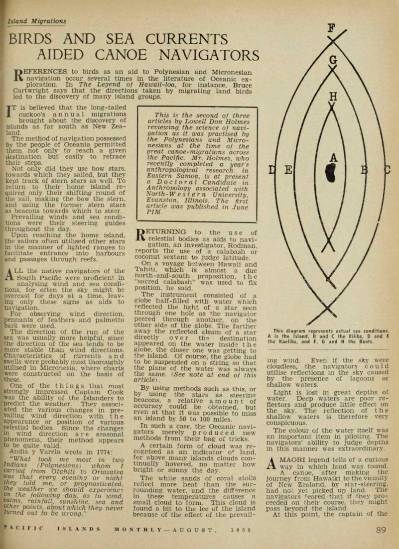
This diagram represents actual sea conditions.
A is the Island, B and C the Rilibs, D and E the Kaelibs, and F, G and H the Boots.
canoe liberated two land birds capable of extended flight The birds circled about, gaining altitude.
At a certain height, they appar ently could see land, for they beaded off in a definite direction This course was followed successfully by the canoe. , The form of the waves and tne direction of swell were used to good advantage in locating land in both Polynesia and Micronesia However, though the Polynesians were fine navigators, it appears that they never studied ocean phenomena and its bearing on navi gation, as the Micronesians did.
It is in Micronesia where charts are constructed depicting the direc tions of swells. , Harold Gatty, who m ,vestigated primitive navigation methods f o the armed forces in World Wai II and who wrote the Raft Book, de scribes these charts as follows.
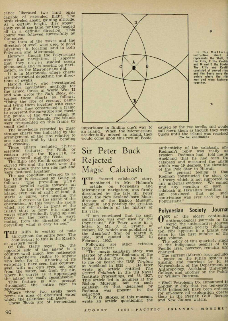
“Using the ribs of coconut palms and tying them together with coco nut fibre, they constructed a frame to represent the curvature and meet ing points of the wave motion in and around the islands. The islands were represented on this frame by Sn rhe knowledge recorded by these strange charts was indicated by the arrangement of the ribs relative to one another and by their bending and crossing. . . , . . p These charts included three essential features; the Rilib, oi eastern swell; the Kaelib, oi western swell; and the Boots.
The Rilib and Kaelib consisted of curved ribs and the Boots were the points where these two ribs met and were fastened together The sea condition referred to as the Rilib is described by Gatty as follows; “The prevailing wind brings parallel swells towards an island. As the swell approaches the island, even out of sight of .land it starts to curve, and nearing the island, it curves to the shape of the obstruction. At this stage, the swells which are directly in front of the island start to form into smaller waves which gradually build up and break on the reefs. This wave motion from the direction of the prevailing wind is easy to see.
THIS Rilib is worthy of note throughout the entire year. The counterpart to this is the Kaelib, or western swell.
Of this, Gatty says; On the opposite side of the island is a counter-swell much less noticeable but nonetheless visible to anyone who looks for it. Knowing of its existence I have seen this counter swell with my own eyes, not only from the water, but from the air, where its curves as it approaches the island are easily recognisable This feature is also present throughout the entire year m Micronesia. .
Where these two swells meet forms an area of disturbed water which the Islanders call Boots These Boots are of tremendous
importance in finding one’s way to an island. When the Micronesians accidentally missed an island, they would come upon this row of Boots,
caused by the two swells, and would sail down them as though they wen buoys until the island was reached (To be concluded)
In this Manhattan instruction chart A represents the Shell, [?] the Rilib, C the Kaelib[?] and D and E the Bootsa The Rilib and Kaelili consisted of curved ribs and the Boots were the points where the ribe met and were fastened together.