Battle Of The Markham, Ng
pp. 12-114 · Read in the full issue
M. J. Leahy Strongly Challenges Official Selection of Site for Quarter-Million Developmental Bridge
THE road made by the Army in 1944, to connect the goldmining towns of the Bulolo Valley, New Guinea, with the port of Lae, has been in general use ever since; but it has one serious disadvantage.
Between the mountains in which the Bulolo Valley is situated, and the coast on which Lae is built, there flows the large, rapid and ever-shifting Markham River.
The Markham River flows into the Huon Gulf about two miles south of Lae.
The Bulolo country is generally southward of the Markham. The Bulolo-Lae road comes out into the Markham about 50 miles from its mouth; and, as the Army roadbuilders could find no place suitable for crossing, they brought their road right down along the south bank of the river, to its mouth; and then they put on a vehicular ferry, which carries trucks and cars across the mouth of the Markham and along a mile of coast, right up to the southern side of Lae town.
The shifting Markham is constantly eroding its southern bank. Again and again, in the last five years, the road has fallen into the river, and stretches of new road have had to be built. The vehicular crossing is frequently menaced by river floodwaters, or storms in Huon Gulf.
OBVIOUSLY, the Markham has to be bridged. The Administration applied itself to the task, and sought the guidance of the Australian Department of Works and Housing (which, in New Guinea, takes the place of a Public Works Department). They, in their wisdom, decided to bridge the shifting treacherous river at Markham Point, about 25 miles from its mouth.
The decision has been challenged by many of the “old hands”; and especially by Mr. M. J. Leahy, one of the pioneers of this area of New Guinea, and now a considerable property-holder in the Zenag highlands (between the Markham and. the Bulolo Valley).
With all the resources at his command, and using an incisive pen, Mr. Leahy attacked the W&H plan; and, finally, his arguments reached the late Territories Minister, Mr. Spender. Mr. Leahy urged Kirklands, much higher up the river, as a more suitable bridge site than Markham Point.
Mr. Spender said the Commonwealth Director-General of Works, guided by expert technical advice, chose Markham Point, and his decision was concurred in by the Administrator. As that means nothing to a practical man, Mr. Spender set out the “considerations” which in fluenced the decision.
It should perhaps be interpolated here that Mr. Leahy’s big argument against the Point site is that if the river is bridged here the road becomes lost in the wilder ness of swamps, hills and deep valleys south of the Markham; whereas if it is kept north of the river as long as possible, it will provide, not only the road to the Bulolo, but also the main highway to the Central Highlands. The natural route to the Highlands is up the Markham Valley (north side of river) to the Ramu Divide, and thence over the ranges into the headwaters of the Purari and Ramu Rivers.
HERE are Mr. Spender’s “considera tions” in black type, and Mr. Leahy’s answers, in light type.
Mr. Spender wrote to Mr. Leahy in April, just before leaving for Washington; and Mr. Leahy’s reply has been sent to
Mr. Hasluck, Mr. Spender’s successor:— The Markham Point site has been proved by boring and is known to be
satisfactory.
No other site has been bored so far.
At this site the river is narrower, better defined and less liable to interruption to the road during flooding of the river than at the Kirkland site.
There has been dumped, and there is still being dumped, into the Markham River, ABOVE Markham Point, hundreds of truck loads of fill in the vain endeavour to stop the rapid erosion of the river
banks along which the road runs. W&H have a deviation ready into which to divert the traffic when the river once again chops away the present road. A conservative estimate of deviations made and eroded away by the river (in this particular stretch of road ABOVE Mark ham Point) in the last four years would be five —and they are still trying to stop it!
The road at Kirklands would run AWAY from the river, NOT along it for a few miles, as at Markham Point. I cannot imagine why the river should be narrower near the coast than at Nadzab, 30 miles inland. It is running through a 200-inch annual rainfall area from Nadzab to Lae, more rivers and creeks flow into it. It is a braided stream from the Umi River, its headwaters, to the coast at Lae. A river usually flattens out and spreads near its mouth. (See next page)
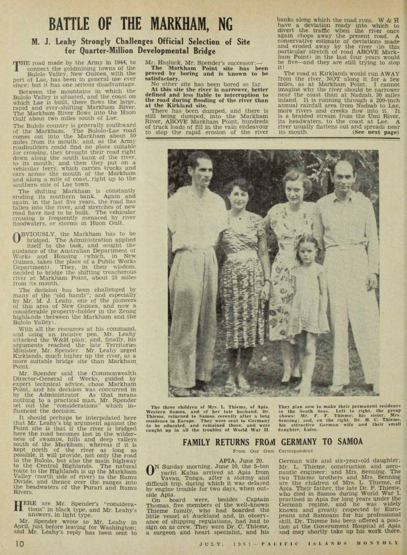
The three children of Mrs. L. Thieme, of Apia, Western Samoa, and of her late husband, Dr.
Thieme, returned to Samoa recently after a long residence in Europe. They were sent to Germany to be educated, and remained there, and were caught up in all the troubles of World War II.
They plan now to make their permanent residence in the South Seas. Left to right, the group shows: Mr. F. F. Thieme; his sister, Mrs.
Senning; and, on the right, Dr. H. C. Thieme, his attractive German wife and their small daughter, Luise.
The estimated time for completion of the work at this site is approximately two years. It is estimated that completion of the work at Kirklands site would re quire approximately four years.
The reason for this must be a close W & H secret. I cannot see why there should be any difference.
The work can be carried out, using the existing camp accommodation at Lae.
The air base at Nadzab abounds in camp sites on concrete, and the Govern ment sawmill is nearby. There are 30 miles of milling timber from Lae to Nad zab. The Agricultural Department has a farm at Erap. Permanent road camps will be needed on the road to Bulolo and the Highlands. In any event, this is a poor reason for influencing the choice of the site of a £250,000 bridge, which will have so much bearing on the future development of this country.
The Kirklands site would involve a great deal more work, both in approach road construction and in bridge work The approach road to the Markham Point site is through heavy timber and swamps which will require many hundreds, perhaps thousands, of tons to fill. There has never been a road to this site from the Lae side. The approach to Kirklands is flat, grass-covered gravel— a grader job only. On the south side the Army had a road. I personally drove on to Kirklands Pt. in a jeep over the Army road in 1944.
It is estimated that completion of the work at this site would require approxi mately four years and would involve twice the cost as compared with the Markham Point site.
I cannot imagine why. I do not think it can be true.
It would also involve a major project in the bridging of the Erap River.
The Erap Bridge would not be a neces sity, as there are other possible bridge sites, below the Erap in the Nadzab area.
In any case, the Erap Bridge would serve the road to the Highlands. The Highlands road MUST go through Nadzab and Erap.
A road to the Highlands on the south side of the Markham is impossible.
It would involve 15 miles additional length of route to the Bulolo area.
This would be a flat and practically straight road. Although 15 miles longer, the trip from Lae to Bulolo via Kirklands would take less driving time, than through the endless bends and sharp pinches of the present road from Markham Point up.
It would involve a fraction of the main tenance required on the road from Markham Point and involve a fraction of the wear and tear on transport the present route entails. It is the only practicable route to move the Bulolo timber to the coast economically. These points can be confirmed by people who are in a position to know.
The road link necessary to join the Kirklands site with the existing road to Wau would be particularly tortuous owing to the nature of the country.
This statement is completely erroneous.
Prom my experience when I drove over it in 1944, it is not nearly so tortuous as the 12 miles of bends, and eight miles of bends, md all the other bends in between Mark ham Point and where the Kirklands road vould join up. Also, the Kirklands road vould be dead flat running, as against the t and 6 wheel drive, low ratio pinches on ;he present road.
The road from Lae to Nadzab is to be •etained, and there will therefore be no •eduction in the road service available. It s estimated that the cost of maintenance >f the Nadzab road to the Erap River to rether with that of the route via Markham *oint would be appreciably less than that or the maintenance of the route via Kirklands to the same interconnection >oint.
This statement is rather ambiguous, but
(Continued on page 111)
if it means that 15 miles of flat, grass covered and sidling cut along bare ridges, will cost more than 30 miles of road from Lae to Erap, IN ADDITION to a dupli cation of that road via Markham Point along the present road to where the Erap-Kirklands road would connect, it is definitely untrue, and could only be made by a person, who does not know what he Is talking about.
The construction of an all-weather road suitable for heavy traffic on the northern side of the Markham River, and between Nadzab and the Ramu Divide, is con sidered impracticable from an engineering standpoint owing to the great number of unstable river channels to be crossed on the Markham Flat.
Do you think the Army would have sent their transports, constructed a 16-wire telephone line, and salvaged planes, etc., along this natural road if a better route existed on the south side? There are more unstable rivers on the south side than on the north side; and, in addition, miles of swamp to be filled, heavy bush country to be cleared, and hard rock points to be climbed over and blasted away. The country should be seen, if one is to fully realise the utter absurdity of these claims.
The through road to the Ramu Valley, and possibly later to Madang, will almost certainly be ultimately located along the south bank of the Markham River until the Umi-Yatu River junction is passed.
This route would serve the pastoral and agricultural lands in the area bounded by the Wampit, Markham and Watut Rivers and between Pesen and Onga; while development of the area north of the Markham River, north of the Umi-Yatu River junction, could be effected by roads
of lower standard, with fords or light bridge structures for crossing wandering stream channels. Any road to the Central Highlands from Lae would branch from this through road.
This is the most fantastic of all the “considerations.” I cannot imagine any sane person advocating a south-side route.
I can assure you one aerial survey flight will convince you on this point.
The whole of the Markham River is pushed against the south side of the valley. The hard backbones of the ranges form the points which jut out into the Markham River. The stretches between the points are erosion and flood bays, mostly swamps or thick scrub country subject to periodic flooding. The route would be 25 per cent, longer. It would be circling the valley, instead of an almost straight line to the lowest gap into the Highlands.
For every acre of pastoral and agri cultural land in the area bounded by the Markham, Wampit and Watut Rivers and between Pesen and Onga on the south side, there are over 100 acres on the north side; and, in addition, that flat grass covered valley runs for 60 to 80 miles below where the road to the Highlands would branch off, and continues on into the scrub and grass-covered flat land of the Mamu and Sepik Rivers, 400-500 miles to the Dutch border.
That is the end of the pro-and-con argument.
T WANT to again stress the urgency of 1 this matter,” says Mr. Leahy. “It affects the future of the country, and will have a direct bearing on whether we can build up a strong first line of defence and an economy which can assist, instead
of depending upon the taxpayer of Aus tralia.
Even if the Kirklands-Nadzab bridge sites presented many times the difficulties (which they definitely do not) of any other route, the defensive and economic advantages of this route so far outweigh every other consideration that it becomes a national tragedy to continue with the Markham Point site.
“The Kirklands-Nadzab route would give this country an all-weather highway to the best air base (Lae) north of Queens land; a flat, almost straight road for 40 miles out of Lae to the Bulolo timber; a timber road on which the largest timber trucks and trailers could operate economically; and, would open up tens of thousands of acres of arable land in the Markham Valley. It would also be 30 miles along the route into the ‘eternal spring’ lands of the Highlands, second only to Kenya in size, and second to none in potential wealth. Here could be pro duced Australia’s £10,000,000 of tea and a
large share of the world’s blending coffee, which is £787 per ton on the London market to-day.
“This Markham Bridge is the most im portant facility in New Guinea to-day.
The whole future development of the interior depends upon it. Short circuit that development by constructing the bridge at Markham Point, and you condemn this country to the ignominious indignity of continuing to be a charge on the Australian Taxpayer.
"I will pay the cost of chartering a plane, and will personally conduct any qualified person you choose to send, to fly over the area in question and check on my statements.”
The Fairymead Co. has taken over Mr.
J. M. Clift’s Aruligo Plantation, in Gua dalcanal, which was wrecked in the war there. The company has commenced erecting new buildings, ipreparatory to tidying up the wreck.