Spice Islands
pp. 16-18 · Read in the full issue
War's Withering Blasts Reach The
Places Dragged From Ancient Romantic Literature to Become Front-page News
'J'HE war in the Pacific is moving • fast to a new and important stage. The Americans and Austra lians, long since, broke the outer perimeter of the Japanese defence system (in the Solomons, New Guinea and the Gilberts ); and they now are going in to take positions from which they can assault the enemy's inner defences.
It is expected that the Americans will make an early move to occupy the Philippines. Already, they have occupied Halmahera and Palau, to
the south, and the south-east of the southern Philippines.
Places which already are involved, or may be involved in operations which appear to be immediately pending, are described in the follow ing article, kindly supplied by the United States Office of War Infor mation.
The Philippines, the Moluccas and the Celebes were discovered and colonised by the Portuguese and the Spaniards more than 400 years ago.
It was there that they found the
delicious, scented fruits and berries which commanded such high prices in Europe; and so it was that these islands became famous, through nearly four centuries of literature, as (( the Spice Islands.”
4,000,000 In The Celebes
rpHE Celebes, one of the Great Sunda -1- islands in the Netherlands Indies, is five times the size of Hainan, and has a population of 4,000,000. Because of its irregular, octopus shape, it was at first mis taken for a group of islands, instead of one land-mass jvith deep bays and an immensely long shoreline—hence its plural name.
The tortuous coast of the wide spread Celebes coast is fringed with dangerous coral reefs. Coco nuts line the shore, and forests of kapok trees are further inland.
Celebes kapok fibre ranks with cork as a filler for life preservers, and the oil from the kapok seeds is valuable.
The tropical climate is tempered by sea breezes, but rainfall is excessive.
Dense forests cover the mountains in the interior and the scenery is varied
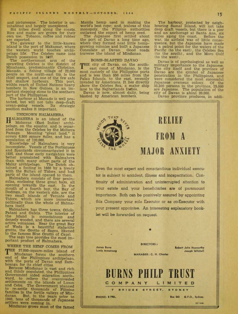
Map shows the areas described.
and picturesque. The interior is un inhabited and largely unexplored.
Six tribes dwell along the coasts.
Rice and maize are grown for their own use. Tobacco, coffee and rubber are exported.
The gateway to the little-known island is the port of Makassar, where the western world touches archi pelago life'. The Celebes came into Dutch possession in 1867.
The northernmost arm of the sprawling Celebes is the district of Minahassa, predominantly Christian.
Manado, a fishing village of 22,000 people on the north-east tip, is the chief seaport, and one of the few safe but shallow harbours. This port, within reach of United Nations heavy bombers in New Guinea, is an im portant stepping stone to the southern part of the Philippines.
The harbour at Manado is well pro tected, but will not take deep-draft ocean-going vessels. Its strategic position makes it important.
Unknown Halmahera
HALMAHERA is an island of the Moluccas (East Indies) archi pelago, on the equator, and is separ ated from the Celebes by the Molucca Passage. Meaning “great land,” it covers 6,500 square miles, and has a population of 120,000.
Knowledge of Halmahera i§ very incomplete. Vessels of the Portuguese and Spaniards circumnavigated it in 1525, and those early navigators were better acquainted with Halmahera than with many other parts of the Malay archipelago. The Dutch ob tained a footing in 1660 by a treaty with the Sultan of Tidore, and had parts of the island opened to them.
Halmahera consists of four penin sulas, enclosing three great bays, all opening towards the east. In the mouth of a fourth bay, the Bay of Dodinga, on the western side, are the two small islands of Ternate and Tidore, which are more imnortant politically than the whole of Halma hera itself.
Halmahera has three towns, Gilolo, Patani and Galela. The interior of the island is mountainous and densely wooded, and there are several active volcanoes. Near the great Bay of Weda is a beautiful stalactite grotto, the Grotto of Sagea, likened to the famous Blue Grotto of Capri.
The sago tree provides the most im portant product of Halmahera.
Where The Hemp Comes From
THE 37,000-square-miles island of A Mindanao forms the southern end of the Philippines archipelago, with the ports of Davao and Zam boanga for its chief cities.
Because Mindanao is vast and rich and thinly populated, the Philippines Government aided migration south ward, to relieve the overcrowded settlements on the islands of Luzon and Cebu. The Government planned to re-settle thousands of Filipino families in the fertile valleys of Min years prior to *940, tens of thousands of Japanese settlers were coming in.
Mindanao grows most of the famed
Manila hemp used in making the world’s best rope; and, jealous of this monopoly, the Filipino authorities outlawed the export of hemp seed.
The Japanese first settled about the port of Davao a long time ago, where they formed neat little hemp growing colonies and built a Japanese Consulate at Davao. Good roads traverse the island of Mindanao.
Bomb-Blasted Davao
THE city of Davao, on the south east coast of Mindanao, is the most easterly of the Philippine ports and is less than 550 miles from the Palau Islands, to the east, recently invaded by Americans. It lies directly above the Celebes Sea, a major ship lane to the Netherlands Indies.
Davao is now, almost daily, being blasted by American bombers.
The harbour, protected by neigh bouring Samal Island, will not take deep draft vessels, but there is a pier and an anchorage at Santa Ana, six miles along the coast. Before the war, its airfield was of little conse quence, but the Japanese have made it a patrol point for the waters of the Pacific (to the east), the Celebes Sea (to the south), and the Moro Gulf (to the west).
Davao is of psychological as well as military importance to the Japanese.
The city itself and the province of Davao are the symbol of Japanese penetration in the Philippines, and were considered the most successful Japanese overseas colony. Of the 35,500 persons in the province, 25,000 are Japanese. The population of the city of Davao is about 20,000.
Davao province produces, in addi
tion to hemp, coconuts and lumber.
To the west it is almost unexplored and, until recently, the only method of reaching Davao was by sea. Now there is a good trans-island road to the west, and a passable road to the north-east.
The city itself is surrounded by rolling plantations. To the west, visible from the city, is the extinct volcano, Mount Apo, loftiest peak in the Philippines.
Bonins—Stepping-Stone
To Japan
rpHE Bonin archipelago, stretching A north of the Marianas, and north-east of the Philippines, a stepping-stone to the south-east of Japan, is 560 miles from Yokohama and 310 miles from southern Japan (Honshu). It dominates the south eastern approach to Yokohama, and lies just north of the ship lanes to the China coast. The Japanese con sider the islands part of the mainland of Japan.
Although the Bonin installations have been kept secret, presumably Japan has concentrated naval and air forces at this strategic part of her inner ring of defence.
The group is of volcanic origin, and there are usually several earthquake tremors a day. It consists of 20 islands, ten of which are large enough to have Japanese place and adminis trative names; and about 77 islets.
The fertile land grows pineapples, palms, cedars, boxwood, ironwood, sandalwood and white oaks. Sugar plantations are the chief economic resource. The temperature, summer and winter, is about 75 deg. Fahr.
The archipelago was apparently not known to the Japanese before its discovery in 1543 by Spanish navi gators. later named by the Japanese “Munin,” meaning “empty of men,” of which Bonin is probably a corruption. Early last century, American whalers customarily put in at the Bonin islands for water and fruits. In 1827, a British ship took possession of the archipelago for George IV. Soon after, however, it was colonised by a group consisting of a Dane, an Englishman, an Italian and 25 Hawaiians, headed by an American, Nathaniel Savory.
In 1853, Commodore Matthew Perry raised the flag of the United States over the islands and formulated an American code of Government, under which Savory was elected Chief Magistrate. Perry envisioned the islands as a coaling station for the
American Fleet. They were not held by the US Government, however, and in 1860 Japan dispatched two officials and 40 colonists to the islands, re named them Ogasawara, and estab lished sovereignty.
Japan pledged in 1922 at the Washington. Conference not to fortify the islands, but for many years foreigners have been strictly barred.
The last alien to enter was an Anglican bishop, who, in 1935, visited the islands’ churches.
10,000,000 Tons Of Bauxite
nPHE Palau group, most westerly of A the Caroline Islands, is a collec tion of 26 principal islands, mandated to Japan by the League of Nations in 1919. United States army forces and US Marines established beach-heads there on September 14.
One of the important features of Palau, aside from its strategic loca tion, is the presence of bauxite deposits of 10,000,000 tons.
The Palau group is only three hours by air from Philippines and New Guinea.
There are about 100 islands in the group, which extends about 77 miles in a north-south direction. There is at least one good harbour where the Japanese Fleet could anchor; but the Jap warships have long since fled northwards.
Dr. Baddeley, Bishop of Melanesia, will shortly visit the United States, where he will undertake deputation work on behalf of the Melanesian Mission.