Deboyne Lagoon, East of Samarai
p. 13 · Read in the full issue
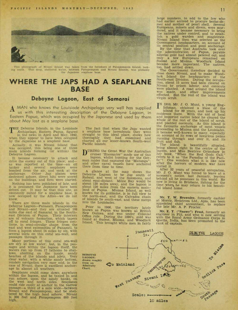
Where The Japs Had A Seaplane
Base
MAN who knows the Louisiode Archipelago very well has supplied us with this interesting description of the Deboyne Lagoon, in Eastern Papua, which was occupied by the Japanese and used by them about May last as a seaplane base.
THE Deboyne Islands, in the Louisiade Archipelago, Eastern Papua, figured in the news in April and May, 1942, when they appear to have been occupied by the Japanese as a seaplane base.
Actually, it was Nivani Island that was occupied, this being one of three main islands forming (or within) the Deboyne Lagoon.
It became necessary to attack and drive the enemy out of this place; and — as was reported at the time —an oil tanker and several seaplanes were bombed from the air, and sank at the anchorage. Other Jap planes were destroyed ashore, direct hits were scored on the buildings, and fires were started.
Nothing has been published of late, and it is presumed the Japanese have been driven out. It may be that this site, so eminently suited for a seaplane base, is now occupied by the Allies—we do not know.
There are three main islands in the Deboyne Lagoon—Panaeati, Panapompom and Nivani—and they are situated 108 miles due east of Samarai, in the South east Division of Papua. Their interiors are of volcanic formation, which tapers off to coral fringes. These fringes con tinue, in semi-circular shape, from the east and west extremities of Panaeati, to form a lagoon about 14 miles by six, with several islets on this coral sea-wall, and passages through it.
Many portions of this coral sea-wall are dry at low water; but, in the pas sages and within the lagoon itself, the waters run up from 17 fathoms to shal lows, abutting on the inside, sandy beaches of the islands and islets. Very clear water, with a white sandy bottom, renders navigation very easy and, in the case of Nivani, there is excellent anchor age in almost all weathers.
Seaplanes could come down anywhere within the lagoon, and be taxied in and run ashore, upon the sandy banks, on the west and north sides. Seaplanes could ride easily at anchor in the narrow passage—a third of a mile wide—between Nivani and Panapompom, and be shel tered by the high land ashore. Nivani is 200 feet and Panapompom 800 feet high.
The fact that when the Japs wanted a seaplane base hereabouts they went straight to this ideal place, shows how thoroughly they had examined and charted all our lesser-known South-west Pacific islands.
DURING the Great War the Australian cruiser “Encounter” made use of this lagoon, whilst hunting for the Ger man raider that captured the “Matunga”; and other naval vessels have anchored there from time to time.
A glance at the map shows the Deboyne Lagoon to be due south of Rabaul, and west of the Solomons, and about equi-distant. Milne Bay would be about 130 miles away, and the lagoon is about 120 miles from the eastern main land of Papua. Misima Island, so well known for its goldmine, is in full view to the north-east, and the Calvados chain of islands lie south-east, and these merge into the Louisiades.
Prior to 1906, the territory lately known as Papua was known as British New Guinea, and was under Colonial Office rule. During the 1890’s, gold was found at Sudest, Misima, and Woodlark island. This brought white men in fairly
large numbers, to add to the few who had earlier arrived to procure beche-de mer and mother of pearl shell. Several Europeans, miners and divers, were mur dered, and it became necessary to bring the natives under control, and to estab lish a gold warden and magistrate.
Nivani Island then was selected as the Government headquarters, on account of its central position and good anchorage.
By the time that Australia took over the administration of Papua, payable alluvial gold had almost petered out, and only a few Europeans remained on Sudest and Misima. Woodlark Island became more important. The natives, too, had settled down.
The Government therefore decided to close down Nivani, and to make Wood lark Island the headquarters of the South-east Division. During the occupa tion, about 15 acres had been cleared on Nivani by prison labour, and coconuts were planted. A road around the Island was made, and other improvements effected. But the rest of the island was virgin scrub.
IN 1910, Mr. J. G. Munt, a young Eng lishman. obtained a lease of the island for 99 years, and took up his residence there. With the aid of local and imported native labor he cleared the whole of the rest of the island of scrub and planted coconuts. As this island is the favourite anchorage of most vessels proceeding to Misima and the Louisiades. it became well-known to many, especially on account of its rows of luxurious palms running through and over it, and its fruit and fish.
The island is beautifully situated, being almost right in the centre of the lagoon, and Miss Beatrice Grimshaw in her book. “When the Red Gods Call,” refers to it as “the Paradise of the Paci fic”! One wonders what it is like now after the horrors of modem war have visited it.
After 32 years of peaceful occupation Mr. J. G. Munt was forced to leave at a moment’s notice, last January, leaving behind all he possesses in this world He now is living in Brisbane, itching for the time when, he may return to his beauti ful island home.
Mr. T. W. Brownlee, formerly cashier at Morris, Hedstrom Ltd., Apia, has been appointed chief accountant, to replace the late Mr. A. P. Procter.
Mr. E. T. (“Snowy”) Frost, formerly an engineer in Fiji, and who is now serving with the Royal Army Ordnance Corps in Quetta, India, has been promoted to the rank of captain.
This photograph of Nivani Island was taken ing south. This deep, sheltered water, between the Japanese
from the foreshore of Panapompom Island, look- Panapompom and Nivani Islands, was probably seaplane base.
Deboyne
Lagoon:
drawn roughly from an Admiralty Chart.