Dangers Of Pacific Navigation
pp. 30-31 · Read in the full issue
Dutch Shipmaster’s Appeal for New Surveys
A N appeal for further hydrographic surveys of the waters in and about the Pacific Territories controlled by Aus tralia was made by Captain J. Blaauboer, master of the K. P. M. steamer “Van Rees,” which arrived in Sydney on Sep tember 11. The “Van Rees” runs on a regular schedule between the East Indies, Papua, New Guinea, New Hebrides, New Caledonia and Sydney, and navigation in those waters is full of dangers.
“Shipmasters can make no complaint if they have adequate charts,” said Captain Blaauboer. “Navigation in good or bad waters is part of their job. But naviga tion around the coasts of Papua and New Guinea is full of risks, even if the greatest care is exercised, because of the almost complete absence of lighthouses, the incomplete charts and the treacherous currents. The course one must follow between Port Moresby, Samarai and Rabaul is most tortuous, there are reefs and islands in all directions and, in thick weather, such as we have had for the last month or two, nagivation is—well, very difficult.
“Shipmasters cannot understand why Australia gives so little attention to the subject of making navigation safer in these waters. You have in New Guinea one of the most efficient and successful aeroplane services in the world; and yet, in the same place, you have one of the worst navigation systems. That there have been so few shipwrecks is a great tribute to the shipmasters who fre quently navigate these seas—particular ly the captains of Burns Philip steamers.
The fact that the “Montoro,” in charge of one of the Company’s best-known cap tains, struck a reef, shows that there is danger in those waters in spite of the greatest care and skill, and the Aus tralian Government should take steps to minimise that danger.
“More lights are most urgently needed.
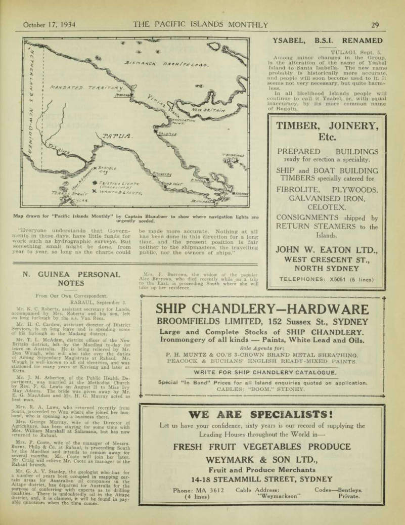
At present, there are lights only at the entrance to Port Moresby; on Kegawan Island, in China Straits; at Cape Vogel, at Salamaua, Madang, and at Rabaul.
As an absolute minimum, there should be lights also at Bramble Cay, at the eastern entrance of Torres Straits (Great North east Channel); at Round Point, on the southern shore of Papua; at or near the Brumer Islands, to show the south-west entrance to the China Straits; at or near the Trobriand Islands, to show the nor thern entrance to the China Straits; and there certainly should be a light some where in Vitiaz Strait, between the New Guinea Mainland and New Britain, where the “Montoro” ran ashore re cently.
“There is now much traffic in these waters, in the vicinity of the China Straits and, without lights and with poor charts, too much responsibility can be thrown upon shipmasters when they are asked to maintain their schedules in thick, rainy weather.
“Most of the charts covering the waters of Papua and New Guinea are antiquated and inadequate—some are almost ludi crous. I have just been using Admiralty Charts Nos. 2422, 2121, 2122, 2123 and 2764, which are the charts to which we must work when navigating the Great North east Channel of Torres Straits and the South and South-east coasts of Papua.
These charts appear to be the result of surveys made in 1843-1850, with some small sectional examinations made since.
Here are some of the annotations on the charts: “‘Several reefs seen in this direction.’ ‘Caution; Owing to the imperfect nature of the survey in the vicinity of Round Point, vessels should proceed with cau tion when navigating here.’ (Yet Round Point is one of the most important points on the South Coast of Papua—vessels proceeding east or west have to alter course here). ‘Position and extent of these islands uncertain.’ ‘Reefs seen by D’Entrecasteaux’ —over 140 years ago.' ‘Reefs seen by Mr. Ashmore in the ship Hibernia, 1811 (not surveyed).’ ‘Reef, Nellie (1889) —position approximate.’ ‘No survey of these waters.’ ‘Limit of reefs uncertain to the southwest.’
“And so on. There are very many of these vague indications of dangerous water, but they provide shipmasters with material only for guesswork.
“Everyone understands that Govern ments in these days, have little funds for work such as hydrographic surveys. But something small might be done, from year to year, so long as the charts could
be made more accurate. Nothing at all has been done in this direction for a long time, and the present position is fair neither to the shipmasters, the travelling public, nor the owners of ships.”
Map drawn for “Pacific Islands Monthly” by Captain Blaauboer to show where navigation lights are urgently needed.