Opportunities In New Guinea
pp. 13-15 · Read in the full issue
Rich Land on Temperate Plateaus Around Head-Waters of Ramu River
The Morobe goldfields, in New Guinea, lie in country so wild and broken that no one has yet been able to build a road into it, and communication with the coast is maintained by aeroplanes.
This very broken country continues northward to the Bismarck Mountains.
Beyond that range the country becomes tamer and more hospitable. It is practic ally unexplored. The maps simply show the wide valley of the Ramu River, lead ing on to the coastal district of Madang.
Hereunder are extracts from the official report of the Madang District Officer, who went up the Ramu Valley last year to make records connected with the discovery of a new goldfield between the Bismarck Mountains and the present Morobe gold field.
This report confirms other reports, that northward and north-west of the Morobe goldfields, in the valleys of the Ramu and Markham Rivers, where the broken in terior mountains grade down to the coastal plateaus, there is a vast tract of fertile country, suitable for development and settle ment.
Attention is directed particularly to the District Officer’s description of the mag nificent plateaus, 5,000 feet high, around the head-waters of the Ramu, where there are , a fertile soil, abundant water, vast plains of grass, and a January morning temperature of under 60 degrees.
It may reasonably be expected that the development of the goldfields, just south of this region, will give a great impetus to European settlement in New Guinea; and that these fertile regions between Morobe and Madang, now practically un known, will receive much attention from prospective agriculturists and pastoralists
THE necessity for a patrol from Madang to south of the Bismarck Ranges (in the mainland of New Guinea) having arisen, contrary to practice, and despite all difficulties, the attempt had to be made in January which is one of the months of the wet season.
This Patrol consisted of the District Officer from Madang, one patrol officer, one native non-commissioned officer and nine constables of native police.
The party proceeded from Madang by the launch Excel to Bogadjim, where native carriers were engaged.
A start made on the track from Bo gadjim to the village of Boak, where camp was made for the night.
Early next day the patrol proceeded and upon reaching the first crossing place it was seen that ordinary fording was impossible. Such eventualities had been anticipated. Two native police, experts in fording swift waters, crossed the river further up and a heaving line was across, then the wire, which was fastened to a tree on either side. A “flying fox” was then rigged with a heaving-line to each bank, cargo was slung to the block and hauled across. The carriers, police and Dis trict Officer and patrol officer crossed in this way. The crossing occupied two hours.
From Ayau the road, which is in ex cellent order, is uphill to Yauls, which has an elevation of 2420 feet and this place was reached at 6 p.m Continuing on from Yauls to Made loi and on through Kesa and Ungu ruma, may improvements were noticed
in the road, and many of the former gradients had been considerably re duced.
In the dry season the Boku forms a short cut to the Ramu Valley. On this occasion, however, it was not negoti able, and the much longer route through Kesa and Unguruma had to be taken.
On the morning of January 2, 1931, when Kesa was left, it was only pos sible to see a few yards ahead owing to dense fog. This was disappointing, as the view on a clear day from the summit of Unguruma Hill down the Ramu Valley is a magnificent one.
From the Boku to the Giagolo river the country is undulating, and no great difficulties were encountered. Good fortune remained with the party, as it was apparent that the Giagolo had been over a mile in width a day or two previously. It was now within its banks and only waist deep.
After leaving this river heavy rain fell until nearing Kesawai. In an in terlude between rainstorms camp was pitched, and the District Officer and patrol officer, after each taking a good stiff dose of quinine, were glad to turn in as the mosquitoes were in myriads.
Some of the police had to maintain smoke smudges all night, and got very little sleep.
Next day the patrol got under way early, but it was a very bad day, the track being through high kunai grass from five to eight feet high, which cut the knees and arms of the whole party and made very bad going.
This portion of the valley appeared to be much drier and had not been recently flooded. The patrol camped the night at Kokomo. Next day some very high patches of kunai were en countered, some of it being 12 and 15 feet high. This same patrol had passed this portion of the country in the pre
vious September, on the return from a patrol in the Rawa area. The kunai had then just been burned off, and it seemed incredible that it had made such growth in this short time.
The Mimia River was found to be very swift but not high. But as there were no trees on the banks the flying fox could not be utilised. Five of the police, found to be expert in carrying gear assisted the carriers, who were not so adept, and everything was got safely across. This day was very hot, with occasional showers, and the Dis trict Officer and patrol officer were so badly burned that on reaching Kai gulin picric acid solution had to be applied to their arms. At this place native foods were abundant, and were purchased with salt. During the night very heavy rain fell and the track from Kaigulin to the Gusap river was under water.
The Gusap river was in flood, both channels running strongly and very deep. A tripod was made of driftwood, which was anchored firmly, and the wire line hauled across and made fast
to a large tree which had been washed down the stream. This had just been completed and the flying fox got into action when a further spate came down, so the line had to be let go and two boys brought back, The patrol camped here until the next morning. The river had fallen, so that by going up stream a mile it was possible to ford it. The two rivers, Gusap and Kuin (or Guin), join and form the Ramu.
From the Gusap the patrol proceeded on to Marawasa, the first village in the Markham Valley. All of the prospec tors who have gone into the Bismarck Ranges appear to have followed a route from this village. As the patrol had neither sextant, chronometer or arti ficial horizon to ascertain their posi tion, the circuitous route, as taken by the prospectors had to be followed to attain their objective.
Marawasa was left on January 7 at 7 a.m., and at 9.45 a.m. an elevation of 2700 feet was reached. The track rose very rapidly, until an altitude of 4000 feet was reached on a kunai ridge. A
thickly wooded mountain had to be then tackled, which reached an alti tude of 5050 feet above sea level. On descending the other side of this, grassed country with timber on the creeks only was encountered. During the night very heavy rain fell, and there was an earth tremor lasting five seconds.
On January 8 the route lay up and down kunai-covered ridges, with many well-defined footpads running in many directions.
This country was an immense, undu lating plateau, at from 5500 to 6500 feet elevation, and about 30 to 40 miles long, with about the same width. One valley reminded the party very much of the Horseshoe Bend and Werribee Gorge as seen from the train nearing Bacchus Marsh in Victoria, without, of course, any of the buildings or orch ards as seen there.
In a ravine a stream was reached, with quite a number of tributary creeks running into it, the general direction being north. This was the Kuin (or Guin), the head of what lower down is the Ramu.
Before reaching the Kuin some natives were found to be following the party. The party was stopped, and they were signalled to come on. After some hesitation they did so.
Each native carried a bow and sev eral arrows, and all were decorated with a beautiful paradise-bird-plume head dress. They brought cucumbers, for which payment was made in salt, and they pointed out a track, saying “Mata Mark,” from which it was con cluded the survey party from Morobe district had returned to the Wau that way. These natives followed the pat rol party to the Kuin and then dis appeared apparently returning on their tracks.
The river being in flood, great diffi culty was experienced in crossing. The steel rope could not be used, as it was impossible for any of the boys to cross to the other side. Eventually a tree was felled, which bridged a channel to a rocky islet in the stream. A second tree was felled to bridge the second channel. The last of the party had just been got across the second bridge when another freshet came down and demolished the bridges.
The nights were very chilly at this time, and it was found necessary to use two blankets. On the plateau, re cords of the 6 a.m. temperatures were kept, which were found to be very even, ranging from 52 to 56 degrees Fahr.
On Fridav, January 9 the trek was continued along this great plateau by following the grass-covered ridges, and natives met with in great numbers.
Their villages are very large and probably permanent, as middens three feet in height by six feet or more in diameter were noticed near many of the houses, which must have been the accumulations of many years. Their houses were circular, with conical roofs, strongly made of timber and cov ered with kunai.
Their gardens are a revelation, and immensely superior to any previously seen by this District Officer in New Guinea, and he had seen as much of the Territory as any other white man.
Most of them are on slopes, with a wide drain across the top. The gar dens are divided into beds by other drains running from the top one.
The gardens are parallel, and straight, long creepers are used as lines in laying them out. They are of uni
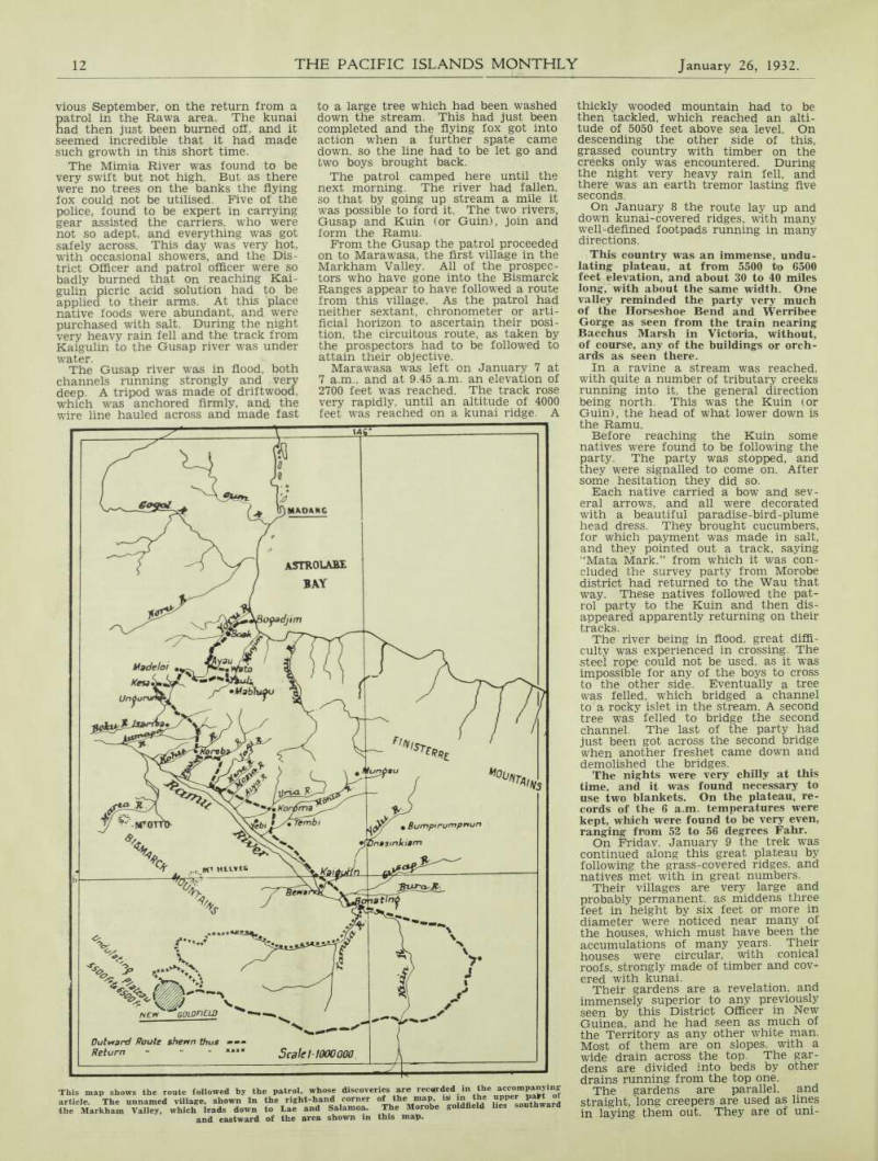
This map shows the route followed by the patrol, whose discoveries are recorded in the accompanying article. The unnamed village, shown in the right-hand corner of the map, is in the upper past of the Markham Valley, which leads down to Lae and Salamoa. The Morobe goldfield lies southward and eastward of the area shown in this map.
form width and depth, yet these people have no iron tools.
Beans of several varieties, in per fectly straight lines, with crossed sticks on which they were trained, were in spected. There were sweet potatoes, maize, cucumbers, pumpkins and sugar cane, and not a single weed in any of the beds.
It would be hard to find a market garden in Australia better laid out or kept than these. The soil is not sim ply turned over in great lumps as with natives generally in this Territory. It is worked to a fine tilth, such as Euro pean gardeners would prepare for a seed bed.
Where could these natives have learned their methods of agriculture, and who could have taught them?
Compared with usual native methods of agriculture, these are a century ahead. There are not just a few iso lated patches, but hundreds of acres.
Every valley has its villages and gar dens, and it would be impossible to guess the number of inhabitants.
At some of these villages 100 to 120 armed men were counted, irrespective of women and children, who appeared to be in great numbers.
In not one instance was any sign of framboesia, tropical ulcers or sores of any kind seen, except a few cases of men wounded by arrows in tribal fighting.
Everywhere the patrol was met with warmest friendship, and huge quanti ties of native foods were brought in, the payment most desired in this area being beads. Salt appears to be un known or unappreciated. Numerous requests were made for small cowrie shells, of which the few who had them appeared to be inordinately proud.
Their implements of war were beau tifully worked and, as iron is unknown to them, the perfection and design of the carving was most surprising.
All communication with these natives was made by signs. As far as it was possible to ascertain, none of the natives on the northern side had ever crossed the Bismarck Ranges, and none of them could speak “pidgin.”
On Monday, January 12, the home ward journey was commenced it being the intention if possible to travel in a north-westerly direction to strike the Ramu just westward of Mt. Otto. But this was found to be impossible.
The patrol proceeded westward across a small wooded ridge, again finding grassed country, with numerous villages and similar wonderful gardens to those as already described. After much difficulty, it was possible to as certain the names of some of these villages—Sumuja, Uriki, Tapulo. Kor omo and Onkuma.
As far as practicable, ridges running in a northerly direction were followed until 5 p.m., when camp was made on the bank of a small stream in a fine wide valley.
There was a steep ridge on the oppo site side of the creek, from the crest of which a number of natives were watching. They were signalled to come down and soon did so. Their atten tions were rather embarrassing. They stroked the arms, chests and backs of the District and patrol officers with their hands.
To the north there seemed to be a pass into the main Bismarck Range, and a track showing signs of much usage was found. This was followed to the thickly-timbered mountains, where numerous plants and flowers previously not known were seen.
At about 11 a.m. some natives were met. They showed great friendliness, and some more pawing took place, to which the District and patrol officers were beginning to get accustomed. The patrol was taken to their village, which was strongly stockaded and in a highly defensible position. Sixty-three houses were counted, and the inhabitants ex plained that there were many other villages near. They were told by signs that it was desired to continue the journey to the north but they indi cated in a similar manner that this was impossible, owing to the rivers in the ravines being too deep to wade, and that there were immense preci pices which it would be impossible to scale. They pointed out a track which led eastward and accompanied the pat rol a short distance. This track led over to the main Bismarck Range at a height of 7100 feet.
From this point the Ramu Valley, with the Finesterre Mountains on the other side, could be seen, whilst on the right there was a deep valley with a river running towards the Ramu. As this was a large stream, it was con eluded it must be the Kuin, but later this was discovered to be incorrect.
From the crest of the range the first descent was most precipitous, and had it not been for the trees and bushes this would not have been negotiable.
In accomplishing a descent of 1500 feet one had to slide from one foothold to another at the base of some tree, sap ling or bush. This was most tiring, but accomplished without accident, and it was astonishing to see that the car riers were able to do it.
On the other side of the ravine a climb had to be made again to a vil lage, from whence numerous other vil lages could be seen. Continuing on up and! down well worn paths, three of these villages were visited.
On these heights dwarf raspberries were found to be flowering and fruit ing profusely, but were more or less tasteless.
The native gardens were found to be the usual irregularly shaped and
poorly-cultivated plots, in marked con trast to those as seen on the other side of the range, The next morning it was decided to take a short cut directly down the mountain to the valley below and fol low the creeks to the river which had been seen, instead of taking the path from the village, by which several days might be occupied by this indirect route to the Ramu.
This turned out to be a most difficult feat. There was thick jungle, through which a track had to be cut to enable the carriers to proceed, and when the creek was eventually reached it was found several times that cascades made further descent impracticable, and new tracks had to be cut around the moun tain contours. Eventually it was found that the first creek emptied into a larger one, down which the patrol pro ceeded, often in the creek itself, ankle deep—at times knee deep, and very often waist deep.
Towards noon the mountains began to draw in, and soon only a narrow gorge was left, down which the water rushed at great speed. It was nego tiated with difficulty. A second gorge lower down was not so dangerous, and the creek gradually broadened out until the river previously seen was reached, As the course was north, it was fol lowed until 5 p.m., when it widened out to about 100 yards and emptied into a larger stream, which turned out to be the Kuin.
A party of natives were seen watch ing from the other bank and signs were made to them to come across, so that a fording place could be found.
The stream was not running very strongly, and as the bottom was sand it was not very difficult to cross— though waist deep, As the patrol was now in familiar country, a start was made for Gusap, in an endeavour to make the crossing before dark. It was successful and camp was made on the western bank, Except for rainstorms and flooded rivers, the return journey to Madang was uneventful.