Tropicalities
pp. 19-22 · Read in the full issue
In these days when very small nations just aren’t tolerated and when the Western Powers are shedding their colonies c s fast as they can go, the 2,000 people of Nukunono, Atafu and Fakaofo —the three atolls that make up the
Tokelau Group—have a burning political problem.
dOULD they link themselves with in dependent Western Samoa or should y become associated with the Cook mds, which are due for internal self ernment next year?
"he islands in question are about 270 es north of Apia and round about three es that distance from Rarotonga, the tre of Cook Islands affairs. \t present, the Tokelaus are adminis ;d by New Zealand through Apia—as y have been since 1925. Before that, y were a very inconveniently-situated t of Great Britain’s Gilbert and Ellice lids Colony. t is probably not generally known that Tokelauans are British subjects and tv Zealand citizens. So if they should ide to throw in their lot with stern Samoa—which, from the point of v of distance and present shipping ser -SS, seems the most sensible thing to do hey would lose their present status. )n Atafu, at least, the people seem re tant to give up this status for when New land’s Governor-General, Sir Bernard gusson, visited that atoll in May, the coming speaker, Faipule Agoni, asked i if land could be made available to his pie in New Zealand. )n Fakaofo, Faipule Itieli said in his coming speech that the New Zealand vernment had asked his people which y they wanted to go, but they were dis jointed because they did not know ctly which direction they should follow. >ir Bernard soothed, but did not really ighten, the troubled people of Fakaofo h a speech which was more or less word word with those that he delivered at ifu and Nukunono. n it, he said that if a change in the itical status of the Tokelaus had to ne, the future would be decided-by the kelauans themselves.
Sir Bernard went on: “Before you are asked to decide, the leaders among you will be invited to see conditions in Samoa and in the Cook Islands, and, after taking your time in seeing both places, you will have time to talk with the other people of the Tokelaus, discuss it, and then make up your minds.
“One thing will not change. For 40 years New Zealand and the Tokelaus have been going hand in hand. Whether you choose to go hand in hand with Samoa or the Cooks, New Zealand will still be able and willing to help you, perhaps by helping Samoa to help you. or by helping the Cooks to help you. We are not going to forget you, any more than the Queen is going to forget you.”
On his return to New Zealand, Sir Ber nard Fergusson said in a talk at the Christ church Rotary Club that the Tokelauans wanted to be left as they were, being ad ministered by New Zealand through the High Commissioner in Apia.
New Guinea's Mace Is The Latest,
But Not The Most Colourful
WAY back in Richard I’s time (1189-99), the serjeants-at-arms of the King’s Bodyguard were armed with maces for the protection of the King’s person. And as the duties of those officers included the appre hension of persons and the summoning of them to the king, the mace came to be regarded as the symbol and warrant of the King’s authority, and was adopted as such by the British Parliament.
Later, as Britain’s empire spread across the seas and her colonies acquired parlia ments of their own, they, too, had to have maces to show that their parliaments were properly constituted. (Over)
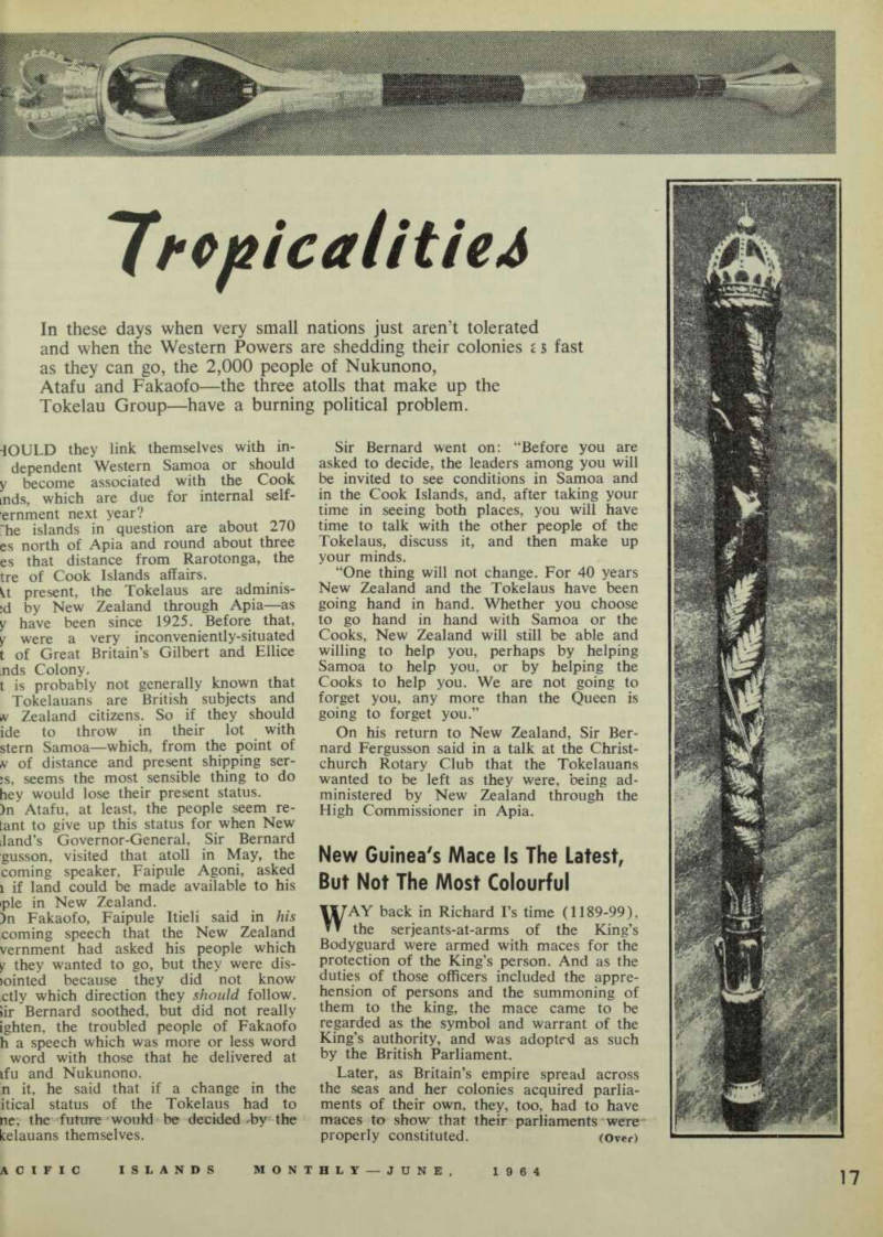
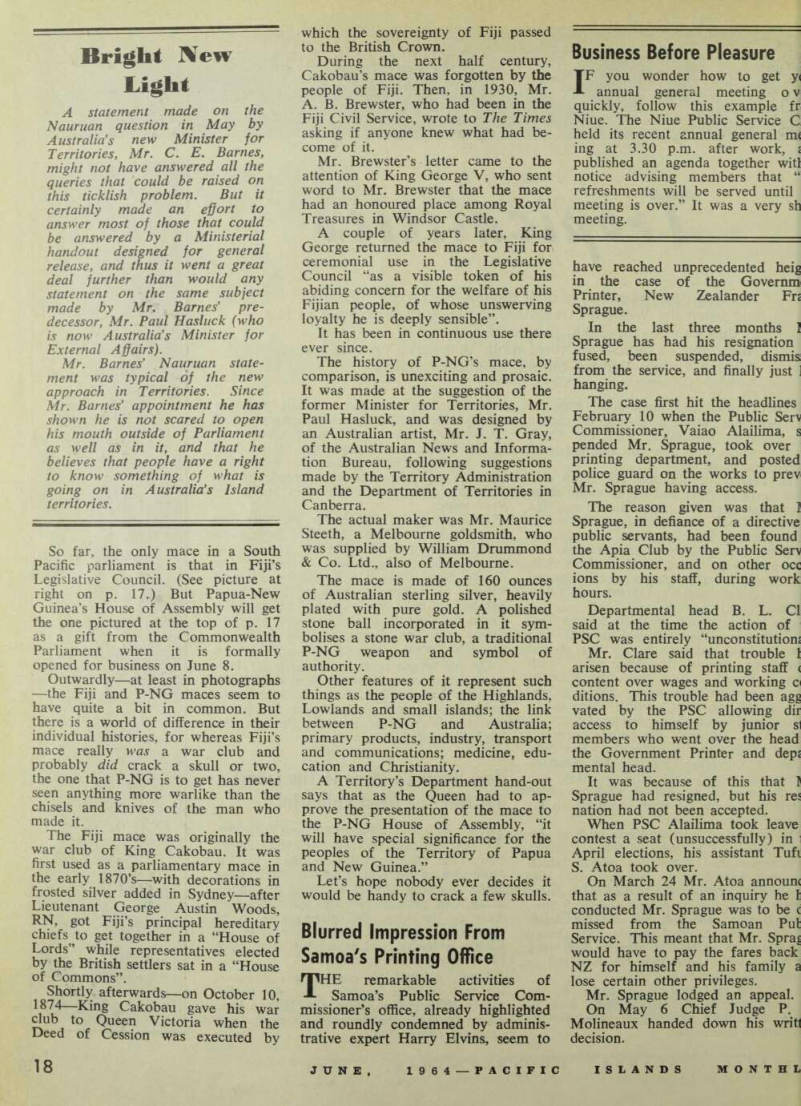
So far, the only mace in a South Pacific parliament is that in Fiji’s Legislative Council. (See picture at right on p. 17.) But Papua-New Guinea’s House of Assembly will get the one pictured at the top of p. 17 as a gift from the Commonwealth Parliament when it is formally opened for business on June 8.
Outwardly—at least in photographs —the Fiji and P-NG maces seem to have quite a bit in common. But there is a world of difference in their individual histories, for whereas Fiji’s mace really was a war club and probably did crack a skull or two, the one that P-NG is to get has never seen anything more warlike than the chisels and knives of the man who made it.
The Fiji mace was originally the war club of King Cakobau. It was first used as a parliamentary mace in the early 1870’s—with decorations in frosted silver added in Sydney—after Lieutenant George Austin Woods, RN, got Fiji’s principal hereditary to get together in a “House of Lords” while representatives elected by the British settlers sat in a “House of Commons”.
Shortly afterwards—on October 10, 1874—King Cakobau gave his war club to Queen Victoria when the Deed of Cession was executed by
which the sovereignty of Fiji passed to the British Crown.
During the next half century, Cakobau’s mace was forgotten by the people of Fiji. Then, in 1930, Mr.
A. B. Brewster, who had been in the Fiji Civil Service, wrote to The Times asking if anyone knew what had be come of it.
Mr. Brewster’s letter came to the attention of King George V, who sent word to Mr. Brewster that the mace had an honoured place among Royal Treasures in Windsor Castle.
A couple of years later. King George returned the mace to Fiji for ceremonial use in the Legislative Council “as a visible token of his abiding concern for the welfare of his Fijian people, of whose unswerving loyalty he is deeply sensible”.
It has been in continuous use there ever since.
The history of P-NG’s mace, by comparison, is unexciting and prosaic.
It was made at the suggestion of the former Minister for Territories, Mr.
Paul Hasluck, and was designed by an Australian artist, Mr. J. T. Gray, of the Australian News and Informa tion Bureau, following suggestions made by the Territory Administration and the Department of Territories in Canberra.
The actual maker was Mr. Maurice Steeth, a Melbourne goldsmith, who was supplied by William Drummond & Co. Ltd., also of Melbourne.
The mace is made of 160 ounces of Australian sterling silver, heavily plated with pure gold. A polished stone ball incorporated in it sym bolises a stone war club, a traditional P-NG weapon and symbol of authority.
Other features of it represent such things as the people of the Highlands, Lowlands and small islands; the link between P-NG and Australia; primary products, industry, transport and communications; medicine, edu cation and Christianity.
A Territory’s Department hand-out says that as the Queen had to ap prove the presentation of the mace to the P-NG House of Assembly, “it will have special significance for the peoples of the Territory of Papua and New Guinea.”
Let’s hope nobody ever decides it would be handy to crack a few skulls.
Blurred Impression From
Samoa's Printing Office
THE remarkable activities of Samoa’s Public Service Com missioner’s office, already highlighted and roundly condemned by adminis trative expert Harry Elvins, seem to
have reached unprecedented heig in the case of the Governm Printer, New Zealander Frt Sprague.
In the last three months I Sprague has had his resignation fused, been suspended, dismis; from the service, and finally just ] hanging.
The case first hit the headlines February 10 when the Public Serv Commissioner, Vaiao Alailima, s pended Mr. Sprague, took over printing department, and posted police guard on the works to prev Mr. Sprague having access.
The reason given was that I Sprague, in defiance of a directive public servants, had been found the Apia Club by the Public Serv Commissioner, and on other occ ions by his staff, during work hours.
Departmental head B. L. Cl; said at the time the action of PSC was entirely “unconstitutiom Mr. Clare said that trouble 1 arisen because of printing staff ( content over wages and working c< ditions. This trouble had been agg vated by the PSC allowing dir access to himself by junior si members who went over the head the Government Printer and dep£ mental head.
It was because of this that J Sprague had resigned, but his res nation had not been accepted.
When PSC Alailima took leave contest a seat (unsuccessfully) in i April elections, his assistant Tufi S. Atoa took over.
On March 24 Mr. Atoa annoum that as a result of an inquiry he i conducted Mr. Sprague was to be c missed from the Samoan Pub Service. This meant that Mr. Sprag would have to pay the fares back NZ for himself and his family a lose certain other privileges.
Mr. Sprague lodged an appeal.
On May 6 Chief Judge P.
Molineaux handed down his writt decision.
fhe judge said the penalty of dis sal was out of all proportion to irregularity of the conduct dis ced. n evidence, Mr. Sprague (repre ted by Mr. R. Metcalf) said that had formed the habit of taking e off from the printing works as ipensation for the long hours of ►aid overtime, sometimes as much 20 hours a week, that he worked. 7 ormer bar manager of the Apia ib, Si’uleo, gave evidence that >lic Service Commissioner Alailima 1 called at the club before the PSC airy and offered him £5O to give lence against Mr. Sprague. He 1 he had refused.
I formed the impression,” said ge Molineaux, “that the practice pted by the appellant, if not ex ssly condoned by his permanent d, at least carried the tacit ac sscence of that officer.
Had his conduct been considered atisfactory the regulations require t he be informed of the fact and in an opportunity to mend his /s . . . There is no evidence that ; was done, and prior to the in ry there was no indication that practice adopted in regard to rtime had met with official dis ►roval.” fhe judge cancelled the penalty of missal and fined Mr. Sprague £3 each of the four occasions he had m found in the Apia Club. For dng failed to keep appointments was severely reprimanded, rhen, a few days after the judge’s diet, Public Service Commissioner ailima claimed that the decision s void because it was unconsti ional. The PSC insisted that under : new constitution the Chief Judge s not entitled now to hear the case his own, but it should have been ird by a three-man appeal board.
Ten days after the Chief Judge’s vision, the perplexed Mr. Sprague md himself still unemployed.
sw Problems For
le Map-makers
IO the sins of commission and omission of our pioneering mdfathers we can now add maps, rticularly the map of Papua and :w Guinea as it relates to terri ial boundaries. This is the con ered opinion of Paul W. van der iur, of the Australian National liversity.
Mr. van der Veur has been work * on the subject and has published findings in an article entitled istralian New Guinea’s borders and elves—lniquities and Idiosyncracies,
in a recent issue of the learned journal, Australian Outlook.
Mr. van der Veur got some quick reactions in Australia, where an article based on his opinions ap peared in a Melbourne newspaper and was followed by questions asked in the Senate, in Canberra.
Did the Minister for External Affairs know, asked Senator Kennelly, that van der Veur claimed that Aus tralian maps showed the border of Papua and New Guinea overlapping into Indonesian territorial waters?
Senator Gorton, answering on be half of the Minister, “found it diffi cult to credit the report”, and spoke at some length on the land boundary between P-NG and West New Guinea, which had, in fact, concerned van der Veur to only minor degree in his article.
What he had complained about were the northern territorial limits of New Guinea, which he claimed were taking in too much ocean; and the southern territorial limits of Papua, which were not taking in enough.
For convenience sake, the map makers have, in relation to the Trust Territory of New Guinea, continued the boundary between that territory and Indonesian West New Guinea (i.e. the 141st. deg. of E. Long.)
clear up to the Equator, then drawn a line along the Equator to 160 deg.
E. Long.
This effectively surrounds the small North-Western Islands, Ninigo and islands north of Manus, but it also encloses vast areas of ocean far be yond the three-mile limit of each individual island, or beyond any other internationally recognised “limit”. This area enclosed, however, does not impinge on anything that could be claimed by Indonesia, and van der Veur did not claim that it did.
If ever challenged, it is unlikely that Australia would have a chance of defending her claim to this area of international water, and of course, the Japanese have been fishing in it for years. It is, in fact, unlikely that Australia ever intended the boundary to be anything but a convenience.
And a convenient alternative it is to the long rigmarole that would have to take its place if one had to describe, in words, a boundary that skirted the correct distance out from the score of small islands in the NW of the Territory that are indubitably Trust Territory properties.
What the Australian map-makers clearly didn’t expect was for Senior Research Fellows in their own ANU
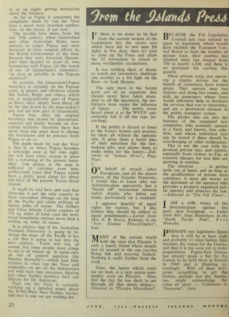
PSSST! DON'T TELL THE RUSSIANS: Last time we published a picture like this — of Fiji's previous Governor, Sir Kenneth Maddocks, and Lady Maddocks—the Russians kicked up a fuss in the United Nations, because, they claimed, carrying people lowers the dignity of the carriers. But in Fiji, the Fijians don't see things that way. Carrying people ashore is an honour they like to bestow on the highest of dignitaries. So when the new Governor, Sir Derek Jakeway, and Lady Jakeway visited Lomaloma, Lau Islands, recently on a familiarisation tour, they got the "treatment".— Photo: Rob Wright.
to sit up nights getting meticulous about the business.
As far as Papua is concerned the complaints made by van der Veur have a much more practical applica tion—in the future, if not now.
The trouble here stems from the late 19th century when Queensland and other Australian States were anxious to annex Papua and were thwarted in their original efforts by the British Government of the time.
Because they were thwarted, Queens land then decided to draw its own boundaries with Papua (in the words of one of Queensland’s statesmen) “as close as possible to the Papuan mainland”.
In practice, the Queensland-Papua boundary is virtually on the Papuan coast, in places; and off-shore islands like Saibai, Boigu and others, which are as geographically part of Papua as Daru, have simply been shorn off by the line drawn by the map-maker’s pen and are now part of Queensland.
Papua was, after the original boundary was drawn by Queensland, annexed and finally became an Aus tralian territory; therefore there has never been any great need to change the boundaries and no pressure from Papua to do so.
The point made by van der Veur is that if, or when, Papua becomes a sovereign state in her own right, she will have every reason to press for a redrawing of the present boun dary. One glance at the map is sufficient to convince even non professional types that Papua would have a pretty good claim for about one-third of the present Torres Strait islands.
It might be said here and now that Australia is not the only country to draw convenient oblongs on the map of the Pacific and claim millions of square miles of ocean. The Gilbert and Ellice Islands Colony consists of 376 sq. miles of land—and the terri torial boundaries enclose more than a million sq. miles of ocean.
It is obvious that if the Australian National University is going to re design the maps of the Pacific it has a job that is going to last into the next century. Truth will out, of course, but some people must cringe to see it all woken up. It needs only an out of context question like Senator Kennelly’s—which had little relation to what van der Veur said originally— to get all the Indonesians out with their tape measures, figuring just what further territory they can liberate for Dr. Soekarno.
Paul van der Veur is currently 7h°J p n Lt a detailed P a P £r about the , P-NG-West New Guinea border, and that is one we are waiting for.