Highlands
pp. 71-80 · Read in the full issue
The Road To The Highlands
With the right kind of vehicle and in the right season, you n, now drive from the coast at Lae more than 300 miles into * centre of New Guinea. But soon neither the vehicle nor ? season will matter much, for the time is near when every irist will take the Road to the Highlands, whatever the ather.
lT road, which has been built iece by piece since the war— ith one or two pieces built dur le war, and one or two others 2 the war—should do a lot ds encouraging the Terri growing tourist industry, the tourist, New Guinea . today means ship travel or avel, and the beauties of the de scene are denied him, simply se the road network has gaps which make arranging of port for him difficult, be wants to make the entire ands road trip today he must . in the “dry” between April October, and still be prepared t his feet wet in a river or 3e will most probably travel in y for section of the way, and by the side of the road. - in a few years it will be an lair drive into the Highlands, he important 90-mile long ham Valley stretch, only two bridges remain to be built i have already been built there, )le to carry heavy traffic) be there will be a clear, unin- Dted drive through to a point xe Papua-New Guinea border Tambul, 320 miles from Lae 5,500 ft up.
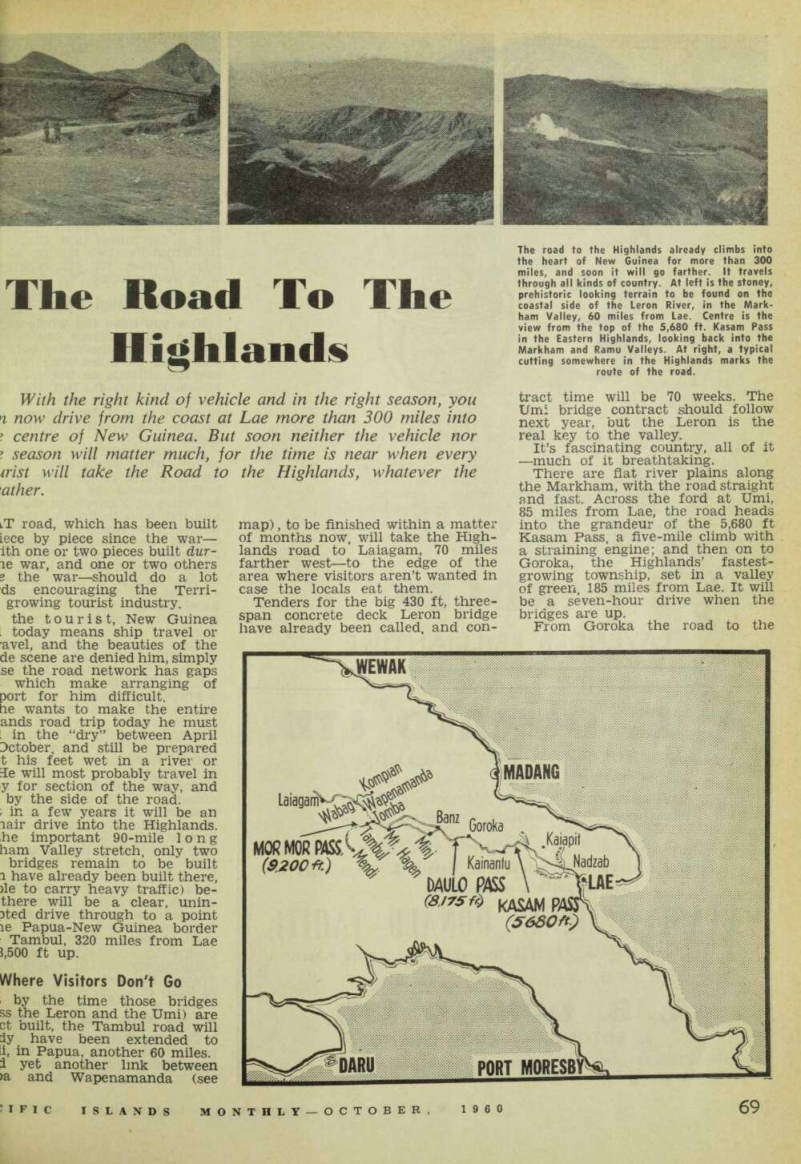
Where Visitors Don't Go by the time those bridges ss the Leron and the Umi) are ct built, the Tambul road will iy have been extended to ii, in Papua, another 60 miles, i yet another link between >a and Wapenamanda (see
map), to be finished within a matter of months now. will take the High lands road to Laiagam, 70 miles farther west—to the edge of the area where visitors aren’t wanted in case the locals eat them.
Tenders for the big 430 ft, three span concrete deck Leron bridge have already been called, and con
tract time will be 70 weeks. The Um: bridge contract should follow next year, but the Leron is the real key to the valley.
It’s fascinating country, all of it —much of it breathtaking.
There are fiat river plains along the Markham, with the road straight and fast. Across the ford at Umi, 85 miles from Lae, the road heads into the grandeur of the 5,680 ft Kasam Pass, a five-mile climb with a straining engine; and then on to Goroka, the Highlands’ fastest growing township, set in a valley of green, 185 miles from Lae. It will be a seven-hour drive when the bridges are up.
From Goroka the road to the
The road to the Highlands already climbs into the heart of New Guinea for more than 300 miles, and soon it will go farther. It travels through all kinds of country. At left is the stoney, prehistoric looking terrain to be found on the coastal side of the Leron River, in the Mark ham Valley, 60 miles from Lae. Centre is the view from the top of the 5,680 ft. Kasam Pass in the Eastern Highlands, looking back into the Markham and Ramu Valleys. At right, a typical cutting somewhere in the Highlands marks the route of the road.
Highlands climbs up through 1 mists of 8,175 ft Daulo Pass, a down again to the Chuave a dim istration post; into Chimbu coum (across a wire bridge) and beyc to the Wahgi Valley, All this is a stretch of coum which Morobe District Commissioi H. L. R. Niall says contains “1 most beautiful scenery in the worl It’s from Kerowagi that you not you are approaching the Wa3 Valley, for here the broken coun opens up. Sixteen miles from Ke wagi is the boundary beiwe Eastern and Western Highlar and a few miles past that is • Hallstrom livestock station at N( dugl, famous for its experime! with wool growing.
The Wahgi Opens Up
Now you have the whole expa: of the Wahgi before you.
At this point the valley is 15 m; wide and 50 miles long, with • average altitude on the valley fl at about 5,200 ft. But the Kul Ranges rise up steeply to the soi to 12,000 ft, and the northern val wall is the 10,000 ft Wahgi-Se divide.
It’s cold and clear in the Wa valley, with warm days and c nights. Coffee grows along the ro The road to the Highlai branches at Kerowil, in the Wal and follows both sides of the Wa River. The main road winds through the township of Banz, w its houses of native materials, £ on to the main district headquart at Mt. Hagen 46 miles away.
When Mt. Hagen at last gets hotel, as it soon will, the dish may take tourist honours fr Goroka.
The other branch road fr < Kerowil runs south through township of Minj, the settl stronghold, and then on to Hag There are several routes fr Hagen itself, but the main road the Highlands goes west as us still following the fiat country, w a nip in the air, to the edge of Hagen Range at Tomba, 28 ra from Hagen.
Now you are approaching the ginnings of New Guinea’s s< mountainous backbone. For the r dozen miles or so the road is ps formed only, and there is a 115 wire suspension bridge still to* built across the Lai River (it ' be finished this year) before road can join up with the manda patrol post, commandinsj beautiful view of the ranges fr one end of the Lai Valley.
It’s 5,800 ft here, but the r begins to rise, gently winding: miles along the Lai Valley flocn Wabag perched on a rainy ric at 7,500 ft.
The Mists Over The Ranges: The Lai Valley has a big naij population and has not long b; out of the restricted area. Thusj has a big mission population, i
ion after mission station spreads g the valley floor, all linked by road to the Highlands, om Wabag, the Highlands road s and turns and climbs in its to the west, in very cold, ntainous country, where the 5 blot out the ranges most noons, and native warriors in capes stare down at your l-Rover from the ridges, iagam is 30 miles away, the *r of the unrestricted area. Out i in those ranges they know ing of civilisation, ere is a fork in the road at jam, going east and farther To the east you can drive ten > to Kepilam, and later that will go to Kandep patrol post, of the new posts established last year to bring under con the primitive peoples of the ri River headwaters, the west, out towards Nether i New Guinea, the Highlands goes down to the Kera River, liles off, and the road is only y completed for another eight to Muriraga. is is farthest west. This is e the road to the Highlands on its westward trek, no tourist area this—not for w years yet. There is much to be done among these Stone peoples first. b road to the Highlands has r branches along its hundreds iles. Some of these go to im nt points now—others will go iportant places in time, or to s destined to be important— there comes a day for sure all New Guinea will be linked 3ad, east and west and from to coast. ere are branches at or near ig into the Tch a k a and nda valleys and to the Kom patrol post, 33 miles away. ? is an 18 miles branch road there to the Ambum River.
Meets The P-NG Border e most interesting branch with oubt is back at Tomba, in the ji, where the road to the High turns south, climbs nine miles irough the 9,200 ft Mor Mor and drops down to the head ’s of the Kaugel River to ml patrol post (7,400 ft), and s again another few miles
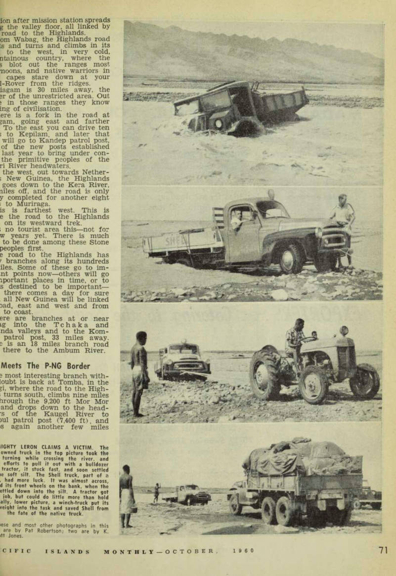
[?]Iighty Leron Claims A Victim. The
[?]owned truck in the top picture took the turning while crossing the river, and efforts to pull it out with a bulldozer tractor, it stuck fast, and soon settled [?]e soft silt. The Shell truck, part of a [?] had more luck. It was almost across, [?]d its front wheels on the bank, when the [?]ettled down into the silt. A tractor got [?]ob, but could do little more than hold ally, lower picture, a winch-truck put its veight into the task and saved Shell from the fate of the native truck. [?]ese and most other photographs in this are by Pat Robertson; two are by K. [?]tt Jones.
nd the western edges of 13,400 t. Giluwe. re. at the border of Papua and Guinea, the road stops. But is going on. ey flew a bulldozer into the not long ago to complete the link to Mendi, headquarters le Southern Highlands. About lies of road already stretches rom Mendi and they are work t both ends to make the link ten the link is finished it will i 87-mile drive from Mt. Hagen to Mendi, with the 9,200 ft Mor Gap the literal highlight e road back to the Stone Age. 3re are ether roads leading Hagen that will give the ;t interesting side trips. One 28 miles out to the Baiyer River r , northwards, and another south to the Hansenide colony goba. and through to new coffee ations. ;k at pretty Kainantu, between :asam Pass and Goroka, a road >outh into the ranges at Okapa,
a centre of the mysterious and fatal disease of kuru, which is now little nearer to solution than when discovered a few years ago. “Laugh ing Death” they call it, from one of its symptoms.
Far From Permanent When the important link-up work on the road to the Highlands is finished, the dream will be a reality, but not perfect. Much work remains to be done before the Highlands road is permanent. None of it is sealed and constant work goes on in maintenance.
Loads of pebbles are being con tinually spread along the inland sections, carried from the river by organised native labour to whom the road is not a tourist attraction but a means by which their produce can go to market, and the doctor can go in.
For much of the way the pebbles are placed the width of the wheel tracks only, to conserve supplies and labour. More work goes into the re pair of bridges put there temporarily and never meant to take the fre quent traffic —hand-built bridges, erected mosly by parol officers turned engineer.
The biggest re-routing of the entire road has yet to come—the re-routing of the Kasam Pass. The present five-mile pass is a winding tortuous climb, difficult for heavy vehicles, with a grade of 1 in 10.
Several alternatives have been looked at, but the new road will go up the pass on the opposite side of the valley, with a grade of 1 in 25. This job is for the near future.
There were several other routes looked at before this one was de cided on. One left the main road at Maniang, crossed the Markham and went up the Wanton to Arona.
Another was a pass up the Arona.
The difficulty with the Wanton and Arona routes was their steep-
These carved native figures are part of the sup ports of the Ufim swing bridge, in the Markham.
[?]culiar thing about the bridge in the top is that it has no water flowing under it. when it was originally built across the out the river changed course—which is [?]sual behaviour for rivers in New Guinea [?]t had to be bridged a second time. The bridge can be seen in the distance, picture is typical of some of the bridg the Highlands—a roof of native materials the weather off the decking, thus giving [?]nger life. This bridge is west of Wabag, [?]ards the end of the Highlands road.
and a clay base. The other side e valley at the Kasam Pass is cheapest and most practicable. 0 for the future —but for the at future—is a new road from mg down the Ramu to link ith the Highlands road at the of the Markham at Gusap. e Japanese built a road in this tion during the war, but it is lat country and there is a very pass to be negotiated at Amele. ips the road could come sooner expected should New Guinea e to build a power station in 3usap area and transmit the r to Madang and Lae. A road 1 be needed to Madang so that r lines could be maintained.
What It's Like
the 185 miles to Goroka, about is along the Markham Valley, s Lae correspondent, Miss Pat rtson, recently accompanied a )y on this 185-mile section just ie what it was like. She re d: you want a holiday with a dif ce, then a reliable vehicle, a some camping gear, a camera an adventurous spirit can give you on this trip, r first lap from Lae, 60 miles e Leron is through rich Mark valley flatlands, irrigated by ral waterways. The cocoa ations and peanut farms give to acre upon acre of rolling s whose potential is evident, it before you reach the mighty i you find “Robbie” Robertson’s odd acre plantation nestling r the shadow of Saw Tooth itain with miles of sorghum and its under cultivation, abbie”, who did a survey of the ham between Lae and Gusap General MacArthur during the has his own lake teeming with and wild duck. th true Territorian hospitality dll invite you in for shooting fishing, haul you across the n, or supply your small needs a store. ur first adventure begins at Leron. iis river, which can flow in
torrents between its mile-wide banks in the wet season, and which looks like an arid desert in the dry, can be crossed in 20 minutes if you’re lucky—and if you’re not, you can get trapped there for hours.
Changing course from hour to hour the narrow swiftly flowing waterway, with its deep silty bottom, is a trap for the unwary and claims many victims. The surest way for a safe crossing is to put a native guide on the bonnet of your truck to direct you to the spots he has previously waded and tested Once across, you’re on to a well
made Open road for 22 miles, acrOSS the Garambampon and Maniang hvirlcrpc tn fhp TTmi Rivpr which has Whicn nas a Crossing.
TWO essentials for comfortable Camping are in good supply on the road—firewood and Water. With a g Un you Can bag some nice ducks on the Garambampon and wild pig i s plentiful.
For a change of scenery you can visit Kaiapit. You leave the main road about a half mile this side 0 f the Maniang bridge for that, and the open road leads through picturesque native villages to the well-kept Government station,
Siqns Are Going Up
Beautiful Kaiapit is on a rise with a wonderful view back down the Markham Valley. It has its own air strip and hospital. A Shell truck in our convoy unloaded some new
Time out for a little bit of washing by a stoney riverside on the road to the Highlands. The family watches Dad. Centre picture is the Leron, looking upstream from the point where the new bridge will cross. Work has already been com pleted on the approaches. At right, somewhere along the Highlands road a native woman pauses for the camera, a bundle of firewood and her kau-kau supplies on her back.
It's a five-mile climb, with a grade of 1 in 10, up the Kasam Pass.
The camera looks down from one bend as this Land-Rover plugs up another.
while we stopped there. They eing erected along the High road. ving Kaiapit and fording the mg, the old patrol road (much e new Markham all-weather doesn’t follow the old patrol passes through well-k ep t ss where friendly natives and meris are the shutterbug’s de en you wind on and up to rfim (which is really the Umi lamed differently in different you find a swing bridge which swings. But the carved figures e bridge are a disappointment. narrow-minded official has id the removal of certain parts , are natural for native carv : swing bridges over the Ufim Fmi are memorials to the work former patrol officer in this -Rupert Haviland. Rupert died )8 so will not see the end of ream. t of the Umi swing bridge is n away and the bridge swings ilts at will. sy are ideal spots, these, for a 5 camping. Game and fish are ful. Orchids grow in pro (Over)
[?]und house is almost at the top of the Pass, and is a memorial to the work [?]rmer patrol officer who had much to do [?]e building of this stretch. Below, new [?]ns have been going up along the High [?]ad—sure sign that it is at last becom [?]lised. The turn-off at Water Rice is the [?] want if you are heading towards the centre of New Guinea.
The turn-off to colourfully named Water Rice can easily be missed be cause the main road, although only a track, here leads to Gusap, and Gusap is not where you want to go.
You call a halt at Water Rice.
You need the breather. Just ahead is the real test of this trip—the great Kasam Pass —five miles of twisting, turning, climbing 1 in 10 slippery mountain. The vehicles are refuelled and checked before the hazardous test begins.
The grandeur of the scenery up the Kasam is breathtaking, as you climb. From your cabin you see fast panned movie shot effects. One minute you are walking on the tree tops; the next your view is of distant and grand valleys; the next, of a tumbling gorge.
Groaning engines are given a breather near the top—although not quite at the top—and you can walk up a slight rise to a round house of native material built as a memorial to Rupert Haviland and
to his work on the Kasam pass road. There has been a plaque erected in that area recently.
Here, stretching away at your feet, is a magnificent view of the Mark ham and Ramu Valleys.
Out there are mile upon mile of plain, and waterways of two great rivers held captive between tower ing hills.
Life Seems Simple
Life seems simple when you climb cut of the pass into beautiful Kainantu and the surrounding dis tricts. The rivers are bridged and the country offers the same mag nificent views and camping spots.
If you have the time you can even stop off and do a bit of gold sluic ing. The red clay of these hills is slashed with waterways where natives are taking out payable quantities of gold.
Kainantu has a comfortable hotel perched on a hill overlooking the town and airstrip. It has a swim
ming pool and modern convenienc The big log fires, and blank at night, remind you that you now in the Eastern Highlands New Guinea —the dividing line tween the Highlands and Morobe fact is at a creek at the foot; the five-mile long Kasam Pas Coffee plantations are thriving the Kainantu district and the tov small civic minded population h made it into a garden paradise.
It’s almost a shame to le Kainantu and head for Gorob 5,140 feet up in the Asaro-B Valley (town’s population, 600).J more beauties, more adventures ahead —for this is hardly the ginning of New Guinea’s great r to the Highlands.