New Guinea Border
pp. 47-53 · Read in the full issue


Not World-Class, But Useful
Oil On The Netherlands Side Of The New Guinea Border
By G. A. V. Stanley
If they can find it, why can’t we? That has been the carrot in front of the donkey, so far as Papua-New Guinea is con cerned, ever since the Klamono field was discovered in Nether lands New Guinea, in 1940.
If many ways the search for oil lin the British, German and I Dutch parts of the great island :S run in parallel. In 1910, as if design, oil-seepages were found jeach of the Territories. In Papua, A. Thomas and Lewis Lett, then Biters near the mouth of the Uala River, found gas-blows and ns of oil, first at Opa, on the bank not far from the mouth, i then at Akauda, on the west ik, about 20 miles upstream. ii German New Guinea, very live oil-seeps were found in 1910 ir Matapau, on the coast about f-way between Wewak and ifape, which are 100 miles apart.
German mining engineer, Dr. R. iilenzig, visited the seeps, which in Wakip Creek, about a mile land; and his report was one of £ documents which fell into Aus lian hands when Rabaul was cap ed in 1914. t is commonly said that a drill- I plant intended to probe at tapau was en route to Rabaul at outbreak of World War I, and -t the ship carrying it was in cepted at Capetown, n Dutch New Guinea, oil-seeps •e found by Lieutenant Binnehdyk the Teer River, a tributary of Biri River, which enters the on the north coast, about 100 es west of Hollandia. They are md, about 20 miles from the sea dine) and were found during the rse of the systematic military lloration of their part of the nd by the Dutch. •r. P. Hubrecht, the geologist at aed to the Army survey parties, orted that in all probability oil xe rocks were widespread in New inea, and in 1914, Dr. W. van st Pellekaan (a Shell geologist) le a preliminary examination of iff localities on the north coast, he Geological Survey of NEI an work on the north coast in Y, 1917. After a year the survey westwards to the Vogelkop.
J work on the north coast was eluded between September, 1920, January, 1922. By that time ay other shows of brine, gas and ’Were known, but over such a vast J, the geology had been done only
■reconnaissance fashion.
Australian Search
In the Australian part of the island the search for oil had been taken over by the Commonwealth, with Dr. Arthur Wade as Director of Oilfields. A number of holes were drilled at Upoia and Orevi on the Vailala River, but Papua was denied the stimulus of an early dis covery, which is almost vital to the rapid development of an oil industry in a new area.
In ex-German New Guinea affairs stagnated until a geological survey was made at Matapau and in the hinterland by H. T. Mayo, J. N.
Montgomery and J. P. de Verteuil, geologists of the First Anglo-Persian party to visit Papua and New Guinea.
In 1924, both Papua and the Man dated Territory were thrown open to private enterprise, with the ex ception of a reserve in Papua be tween Yule Island and the Lakekamu River (roughly), retained by the Commonwealth Government to be exploited by drilling at Popo.
On NNG Side The three producing oilfields of NNG are all situated in the Vogelkop (map p. 45). All are characterised by cil seepages, which were discovered first by the Army surveyors between 1910 and 1916. Surveys by geologists of the Geological Survey by 1924 had
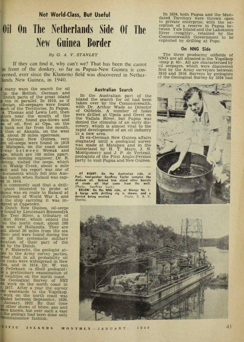
AT RIGHT: On the Australian side, ot Puri, tool-pusher Geoffrey Taylor samples the dinkum oil. Behind him stand other barrels of crude oil that came from the well. (Photo: Geoffrey Luck).
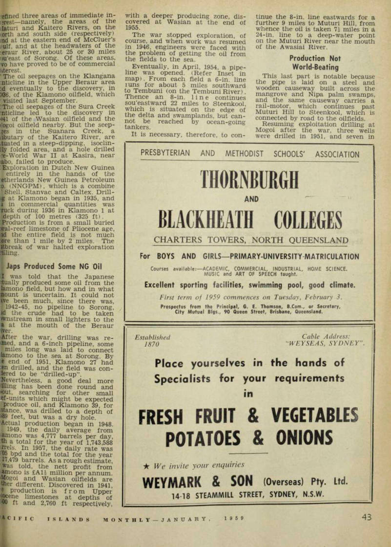
BELOW: On the NNG side, at Niengo No. 1.
A barge with drilling rig is shown, and a derrick being erected. Photo: G. A. V.
Stanley.
efined three areas of immediate in vest—namely, the areas of the [aturi and Kaitero Rivers, on the corth and south side (respectively) nd at the eastern end of McCluer’s j>ulf. and at the headwaters of the :eraur River, about 25 or 30 miles m'east of Sorong. Of these areas, vo have proved to be of commercial fiterest. ’ The oil seepages on the Klangana mticline in the Upper Beraur area :d eventually to the discovery, in 336, of the Klamono oilfield, which ’ visited last September.
I The oil seepages of the Sura Creek mticline led to the discovery in >I4I of the Wasian oilfield and the >[ogoi oilfield nearby. But the seep ges in the Suanara Creek, a jibutary of the Kaitero River, are .tuated in a steep-dipping, isoclin- Jly folded area, and a hole drilled :e-World War II at Kasira, near fabo, failed to produce. [Exploration in Dutch New Guinea I entirely in the hands of the Netherlands New Guinea Petroleum o. (NNGPM), which is a combine I Shell, Stanvac and Caltex. Drill g at Klamono began in 1935, and i in commercial quantities was Tuck during 1936 in Klamono 1 at depth of 100 metres (325 ft). [production is from a small buried [ffal-reef limestone of Pliocene age, id the entire field is not much :ore than 1 mile by 2 miles. The ■break of war halted exploration
tiling.
Japs Produced Some NG Oil
I was told that the Japanese dually produced some oil from the lamono field, but how and in what ;nount is uncertain. It could not ive been much, since there was, 1 1942-45, no pipeline to Sorong, id the crude had to be taken ■mstream in small lighters to the a at the mouth of the Beraur iver.
After the war, drilling was re ined, and a 6-inch pipeline, some Imiles long was laid to connect lamono to the sea at Sorong. By e end of 1951, Klamono 27 had «n drilled, and the field was cen tered to be “drilled-up”. [Nevertheless, a good deal more illling has been done round and "out. searching for other small ef-units which might be expected produce oil, and Klamono 39, for istance, was drilled to a depth of •89 feet, but was a dry hole.
Actual production began in 1948. ; 1949, the daily average from lamono was 4,777 barrels per day, th a total for the year of 1,743,588 [Pels. In 1957, the daily rate was 05 bpd and the total for the year 17,479 barrels. As a rough estimate, Was told, the nett profit from amono is £AU million per annum.
Wtogoi and Wasian oilfields are tner different. Discovered in 1941, ? production is from Upper !|jcene limestones at depths of 'OO ft and 2,760 ft respectively,
with a deeper producing zone, dis covered at Wasian at the end of 1955.
The war stopped exploration, of course, and when work was resumed in 1946, engineers were faced with the problem of getting the oil from the fields to the sea.
Eventually, in April, 1954, a pipe line was opened. (Refer Inset in map). From each field a 6-in. line runs for about 5 miles southward to Tembuni (on the Tembuni River).
Thence an 8-in. line continues sou’eastward 22 miles to Steenkool, which is situated on the edge of the delta and swamplands, but can not be reached by ocean-going tankers.
It is necessary, therefore, to con
tinue the 8-in. line eastwards for a further 9 miles to Muturi Hill, from whence the oil is taken 7i miles in a 24-in. line to a deep-water point on the Muturi River near the mouth of the Awasiai River.
Production Not
World-Beating
This last part is notable because the pipe is laid on a steel and wooden causeway built across the mangrove and Nipa palm swamps, and the same causeway carries a rail-motor, which continues past Muturi Hill to Steenkool, which is connected by road to the oilfields.
Resuming exploitation drilling at Mogoi after the war, three wells were drilled in 1951, and seven in
2, production being got at depths the order of 1,300 ft.
Wasian, three wells were corn ed in 1952, production being 01 depths of around 3,000 ft.
Hogoi has been a disappointment, ■fting in 1954 with a production ly of 5,656 bpd, edge-water has ckly encroached, and in 1957 pro- Jon had declined to 523 bpd. me yearly total fell from 2,064,463 jjels in 1954 to 190,655 barrels in IJasian, on the other hand, Jted with a daily production, in 'r. °f only 639 bpd, rising to 1,328 to the discovery jthe deeper producing zone ’fcdy mentioned. However, in 1957,
production fell off to 1,020 bpd. The yearly figures were: 233,237 barrels in 1954; 486,162 barrels in 1956; and 372,293 barrels in 1957.
Production figures like these are scarcely in the world-class, but nevertheless they are quite useful.
From time to time, one hears talk that unless new discoveries are made by 1960, NNGPM will close down.
How much reliance is to be given to such stories in anybody’s guess.
At NNGPM headquarters at Sorong, one finds a strong and vigor ous body of experienced geologists and geophysicists re-working over almost the whole of Dutch New Guinea on a regional scale. Since 1946, over 50 exploration tests have
A sketch map o f V ogelk op area of Neth erlands New Guinea, and, inset, a large scale ot the area described in this article. '
This is the now famous Puri No. 1 site, deep in Papua’s Gulf country 1 hush, and the well from which on November 4, 1958, oil was flowing at the rate of 1,000 barrels a day. There followed a minor boom in Oil Search shares but when water started to flow as well as oil, there was a slump. \(Shares that reached 26/- in November were down to about 8/6 in January) Since Vacuum and BP announced that they would continue in Papua there has been very little further information from them. It is understood that APC is now, however, preparing to drill new wells 1 around the Puri area.
been drilled, quite apart from ex ploitation holes.
They are located mostly in the -vogelkop area, on other known anticlinal structures; but some are as far afield as Aripu 1 (on the IDigul River, below Tanah Merah) and Merauke 1 (on the south coast, about 75 miles nor’west of the Aus tralian border), while Gesa 1 and 2 'Mamberamo X and Niengo 1 are on me north coast, around and west of the mouth of the great Mam
•beramo River.
Niengo 1 is notable in that it is Pemg drilled from a floating plat i°rm, after the style of the rigs used jor offshore drilling in the Gulf of [JJexico and elsewhere, but moored rather than resting on extensible ,le gs. (See photo p. 41)
Again, about 35 miles sou’sou’west of Sorong is the Sele oilfield, where, up to the end of 1956 no less than 49 holes had been drilled, to depths of 3,898 ft. (in the case of Sele 42), which was dry. A number of holes has produced oil from varying depths: for example, at 2,520 ft (Sele 41), 2,238 ft (Sele 43), 2,526 ft (Sele 44) and 2,247 ft (Sele 48).
Presumably, Sele is now drilled-up, and its capacity to produce is known.
Some day it may be put on to pro duction.
Speculating, it may perhaps not be expedient to bring in and de velop oilfields at present in this part of the Southwest Pacific.
Maybe even Puri ( PIM for De cember) must wait.