the Brows of Islands Skippers
pp. 84-85 · Read in the full issue
Radar In Ship Navigation
The Magic Black Box That Smooths the Brows of Islands Skippers
By. Capt. Brett Hilder
TO the harassed navigator radar has come as a boon and a blessing, acting like Alladm s Genie of the Lamp, solving problems from its magic black box. It re stores confidence and soothes anxious nerves like a magic balm, and is the greatest aid to inter-island naviga tion since the introduction of charts and the magnetic compass. In fact, for close pilotage, it almost super sedes the compass. . , Navigating through the isles of the Pacific calls for a lot of night navigation, in addition to periods of bad visibility due to rain haze or volcanic dust. In the past, this has caused a lot of eye strain, and hours of peering through binoculars at murky horizons, trying to pick out the land from the clouds.
Sometimes, at close quarters, on dark and stormy nights the only glimpses of the land are in flashes of lighting, and often it was neces sary to go dangerously close to land or breaking reefs in order to pick them up at all. All these anxieties can now be modified by ships which are lucky enough to carry radar.
All Burns Philp ships are now fitted with it, largely as a result of the stranding of SS Mangold three years ago on Kar Kar Island (NG).
This was one type of accident that radar could have prevented.
Radar consists of a combined transmitter and receiver about the size of a man and situated on top of the bridge; and several large boxes of electromagnetic mysteries which project their answers in visual form onto a luminous screen rather like a television set.
Radar uses radio waves of very high frequency, that is, of very short wave length, about an inch in length, compared with ordinary short-wave radio which has a wave length of about 20 yards.
Radio waves are identical in nature to light waves, except for their higher frequency, and radar uses them as a substitute for eyesight.
As well, it does a lot more, tor a radar set transmits its waves in a beam which sweeps around the horizon, illuminating any object it strikes, and then receives back any echoes which are strong enough to record on the screen.
Our eyes can see only objects which either produce their own light, or are illuminated by other sources. Even if our eyes were fitted with searchlights they would still not do all that radar does, for
as well as seeing objects and record ing them on a screen, it also measures their distance off very accurately, by automatically timing the echoes and showing all these distances on the screen.
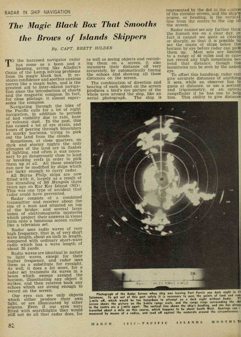
The combination of direction and bearing of each object on the screen produces a bird’s eye picture of the whole area around the ship, like an aerial photograph. The ship is
represented by the dot in the csntres of the circular screen, and the ship’s course, or heading, is the vertical line from the centre to the top oft the screen.
Radar cannot see any further tham the human eye on a clear day, im fact it cannot see quite as or sharply, so that it is possible to: see the masts of ships below the horizon by eye before radar can pickn them up. Most sets are- limited) to a range of 40 miles and so can not record any high mountains be yond that distance, though the mountains can be seen by the naked) eye.
To offset this handicap, radar can give accurate distances of anything it sees, while an observer has to guess at distance, or use a sextant and trigonometry, or an optical rangefinder if he has one to help him. This ability to give distance:
Photograph of the Radar Screen when ship was leaving Port Purvis one d a rk night in t[?] Solomons. To get out of this port safely it is necessary to pass the Points of land and re[?] ¼-mile off which would be too hazardous to attempt on a dark night without Radar. T[?] screen shows the picture on the 3-mile range scale, and the range rings surrounding the sh[?] in the centre are a ½-mile apart. The vertcal line shows the ship's heading, and she has alrea[?] travelled about a mile on this course, which happens to be about South West. Bearings can [?] measured by means of a radius, and read off against the numerals around the circumference.
ff is of very great value in naviga ion.
When navigating by eye at night, yen when land is visible and it is ossible to take compass bearings f it, it is often very difficult to eep the necessary distance off it to yoid unseen dangers like rocks and lallow reefs. A bearing and dist nce by radar of a single object ill give an accurate position of the lip, and ensure her safety.
The later type of radar set has ;en designed for accuracy for short stances to enable ships to enter irbours in fog or rain, by being )le to pilot by radar past floating loys and fixed beacons, as well dodging other ships in the irbour.
To enable all this to be done on e screen, the range can be limited one mile, instead of showing up 40 miles, and this, of course, gives picture of the vicinity just 40 nes larger. rhe set may also be switched to termediate ranges, usually a 3le and a 10-mile scale, for coast s' pilotage. The one set therefore fils most of the functions needed it in ship navigation. well as looking at the horizon, * beam looks a little above and ow, and we therefore get heavy n clouds showing up on the pic e, and also the waves of the sea we could cut out the return m the waves, we would also : out any small boats, buoys, idbanks, and lines of breakers h as mark the edges of reefs, .ches, rocks and tide-rips. 5y tuning the set with different .trols it is possible to distinguish vy rain clouds from solid land oes, and to diminish the sea arn and show the rest of the :ure more clearly, rather in the le way as a radio is tuned to get best reception of a broadcast, here is a lot for the observer earn to get the best results from radar. lERE is a danger that the con fidence inspired by radar may lead to over-confidence, so that ead of slowing down or coming complete stop in dangerous cir istances, a shipmaster may be pted to charge on, regardless of mess or poor visibility, and run collision, strandings or the wrong ; by mistake. » many collisions have occurred ind Europe by ships using radar the expression has been coined, iar-assisted collisions.” For a one ship, in fog or rain, picks nother by radar she cannot tell ;her the other ship is fitted with r or not and her evasive action therwise often turns out to be the wrong thing to do. so, with radar, there is not the ; visual recognition of objects lat boats may be mistaken for nation buoys, and ships mistaken small islands, or islands mis i for each other. All these
mistakes must be guarded against, for the whole object of fitting radar to ships is to increase the safety factor, not just to make things easier for navigators.
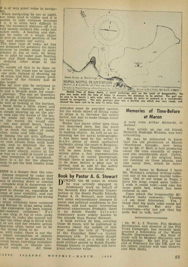
Radar has many other uses than are described here, but the main one so far unmentioned is its use in making charts. As well as an in creasing use for naval hydrography, it has been used by the writer to make plans of small uncharted harbours along the coast of Bougain ville, and two on Guadalcanal. It will be seen from this that the screen gives a fair representation of a chart, or aerial photograph, though there is quite a lot of work to be done before a plan can be plotted, and so add to the safety of navigation in the South Seas. ‘
Sketch Plan of Numa Numa, a small anchorage port on the coast of Bougainville; the plan was made with the help of Rader to measure the distances to be plotted. The port can be seen to be barely ½ mile wide, while the reef extends 3¼ miles to seaward as a considerable hazard to navigation. The only previous plan was a German one which was very rough, and showed the main reef to be only 1¼ miles long.